Slow Clearing Through Tonight Severe Weather Risk Tuesday
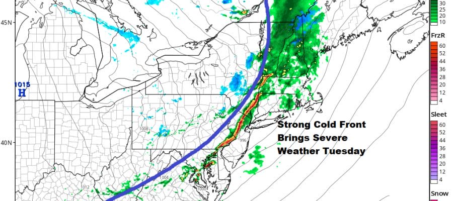
We continue to monitor the risk for severe weather Tuesday as a strong cold front heads into the Northeast and Middle Atlantic states. This severe weather risk is being driven by a strong short wave in the northern part of the jet stream and not from a strong surge of tropical air up the East Coast. The upper trough will create a very unstable atmosphere on Tuesday and the main threat from these storms would be the potential of damaging winds.
SATELLITE

REGIONAL RADAR

Before we deal with Tuesday we are sitting in clouds this afternoon as a coastal storm offshore strengthens and moves to the Northeast. We are still seeing rain just offshore but it is sliding to the east. Dry air to the northwest will gradually move in late today and skies should start to clear out from northwest to southeast as we head into this evening. We should be clear for much of tonight. Lows tonight will be in the upper 30s to mid 40s.
LOCAL RADAR NEW YORK CITY

LOCAL RADAR PHILADELPHIA


The cold front approaches Tuesday with arriving clouds. Highs will reach the upper 50s and lower 60s. The front will create a line of thunderstorms in Pennsylvania and they will swing through New Jersey and then to the coast. These storms and the associated cold front will move very quickly as they rocket across the area between 1 and 5pm.

Confidence is high given the fact that most of the models are very similar in developing a strong squall line of the thunderstorms. The NAM model and HRRR model are almost identical in how they handle the front.

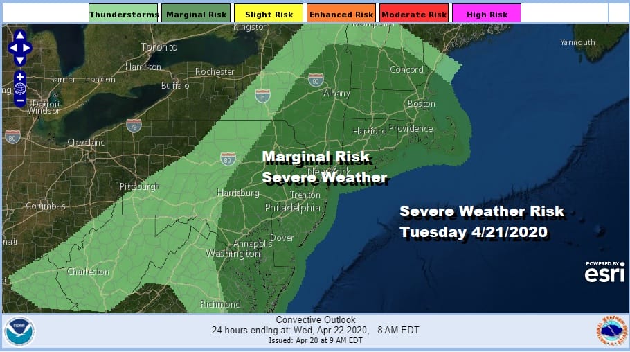
We are expecting the Storm Prediction Center to up the ante to a slight risk forecast once we see how unstable the atmosphere will be on Tuesday. Weather conditions will improve behind the front though it will be windy and colder. Wednesday morning lows will be in the 30s. Sunshine Wednesday will take highs up to the mid and upper 50s. Weather conditions will deteriorate on Thursday as the next storm system approaches. We will deal with this with a longer range post later today.
BE SURE TO DOWNLOAD THE FREE METEOROLOGIST JOE CIOFFI WEATHER APP &
ANGRY BEN’S FREE WEATHER APP “THE ANGRY WEATHERMAN!
MANY THANKS TO TROPICAL TIDBITS FOR THE USE OF MAPS
Please note that with regards to any severe weather, tropical storms, or hurricanes, should a storm be threatening, please consult your local National Weather Service office or your local government officials about what action you should be taking to protect life and property.


