
Showers Tonight Onshore Flow Coastal Storm Creates Uncertainty Rest of the Week
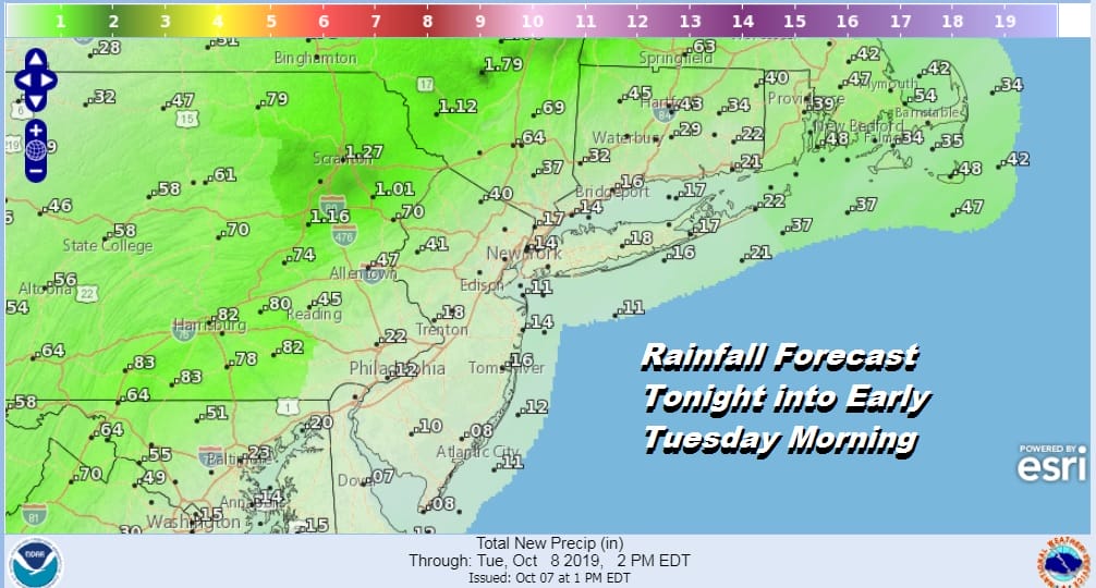
The cold front to the west is slowly moving eastward. The progress has been very slow and we will likely see rain reach western New Jersey this evening and shortly after that along the coast. The rains have been on the moderate to heavy side across Central and Western Pennsylvania today but the rain area will start to weaken as it moves eastward. The cold front will lose support aloft so while there will be showers around, amounts will lessen considerably for areas while they will be more robust from Western New Jersey, the Hudson Valley (north of Route 84) and Northwest Connecticut.
SATELLITE

REGIONAL RADAR

Regional radar shows the wall of rain to the west and north and while we are seeing some showers starting to show up on the local radars, they are not impressive. We don’t expect thunderstorms to develop with this front since the front is weakening as it moves east.
LOCAL RADAR NEW YORK CITY

LOCAL RADAR PHILADELPHIA


Temperatures tonight will settle in the 50s by morning once the front passes offshore and basically dissipates. Tuesday we will start to see high pressure build to the north and an onshore flow developing as the day wears on. Low pressure will be developing off the Southeast coast of the US, however there should be enough dry air around to allow for some breaks of sun to develop in most areas with more sun north of NYC and more clouds as you head south and east. No rain is forecast for Tuesday with highs in the 60s to near 70.
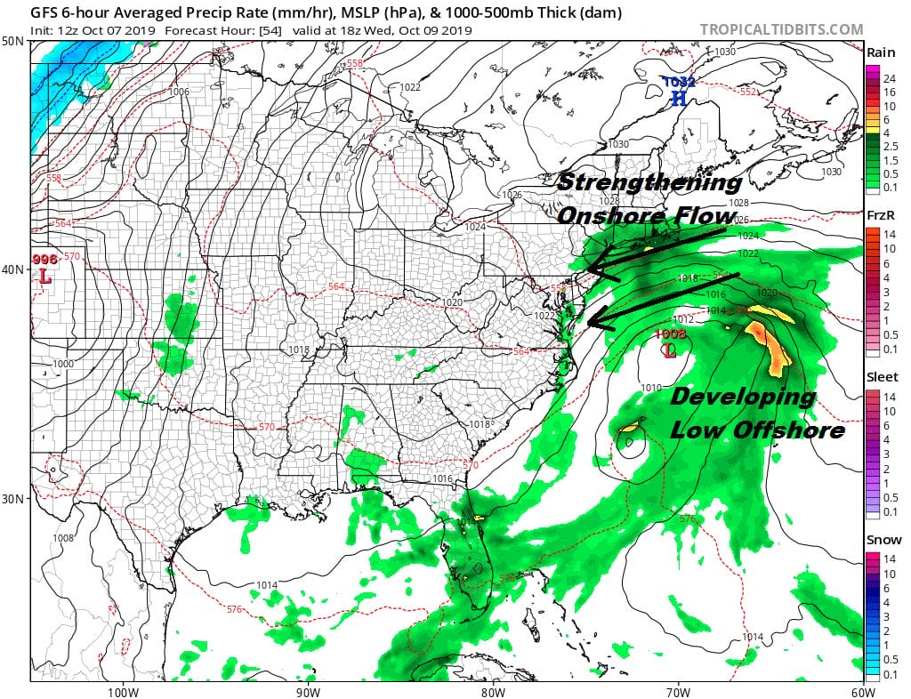
Tuesday night into Wednesday as the low develops to the south and the pressure gradient tightens we will see rain spread westward from the offshore low. Rain will spread inland but it some point it does cut off in Eastern Pennsylvania and in the Hudson Valley north of Route 84. Along the coast gusty northeast to east winds will dominate. Temperatures will be in the raw 50s and when it is not raining we will likely see drizzle around. We continue to monitor this for the possibility of some subtropical development since the low is over very warm ocean water east of Virginia. Coastal flooding is possible at high tides however we are fortunately in a low tide cycle in between the new and full moon.
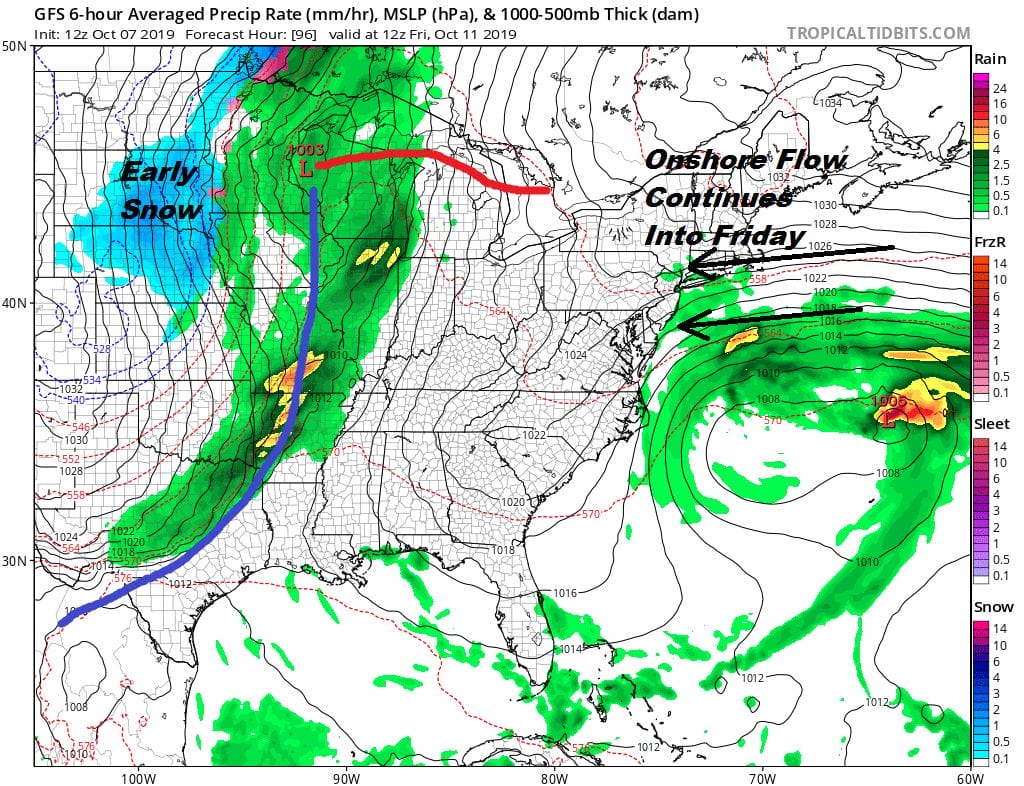
This low is not going to be going anywhere fast as it is blocked by a high to the north and a possible tropical depression or tropical storm that is forecast to develop well to the east. This pins us in raw conditions with on and off rain or drizzle right into Friday. This will keep daytime temperatures mostly in the 50s both Thursday and possibly even on Friday. To the west we have low pressure heading to the Western Great Lakes bringing early snows to the Northern Plains. This system will finally start to dislodge the atmospheric traffic jam so that weather conditions will improve over the weekend.
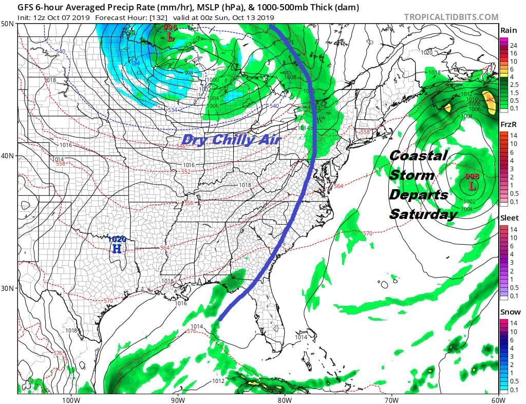
The next front from the Plains/Great Lakes system won’t have much with it. We should see some breaks of sunshine developing ahead of it on Saturday as the coastal low moves away to the east. Highs Saturday should reach the upper 60s to near 70. The front may get hung up a it on Sunday with clouds and the risk for a passing shower with highs in the 60s. Long range there are hints of another coastal low developing for later next week
MANY THANKS TO TROPICAL TIDBITS FOR THE USE OF MAPS
Please note that with regards to any severe weather, tropical storms, or hurricanes, should a storm be threatening, please consult your local National Weather Service office or your local government officials about what action you should be taking to protect life and property.


