Coastal Low Onshore Flow Wind Rain Coastal Flooding Issues Wednesday Through Friday
It has been quite a long stretch that Long Island has not seen a round of gales, rain, and coastal flooding. We haven’t seen much noreaster activity nor have had any tropical storm or hurricane threats so far this season. We are seeing a coastal low threat developing bringing on and off rain, wind with gales along the coast, and the chance for coastal flooding over multiple high tide cycles beginning Tuesday night and lasting into at least Friday.
SATELLITE

This evening we see a ton of clouds across Pennsylvania and upstate NY where it has been raining for much of the day. Meanwhile we had a fair amount of sun on Long Island today especially over Suffolk County with temperatures in the 70s and a gusty south wind. We are still waiting for showers to come in from the west and even though the regional radar shows a fairly solid area of rain, this area will weaken as it moves eastward.
REGIONAL RADAR

The evening commute should finish with no rain issues but some showers are likely overnight. I don’t believe there will be that much rain from this front with rainfall amounts of a quarter of an inch or less.
LOCAL RADAR NEW YORK CITY

LOCAL RADAR PHILADELPHIA 

Tuesday we will see clouds and some breaks of sun but the wind will be picking up from the northeast as high pressure builds to the north of us. Temperatures tonight will bottom in the mid 50s to near 60 and highs Tuesday will be in the low to mid 60s.

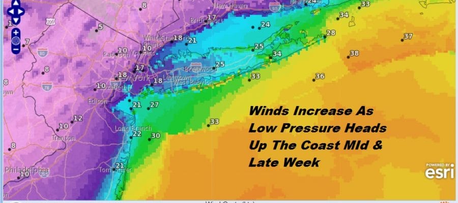
Tuesday night attention shifts to low pressure developing off the Southeast coast of the US and moving northward. Normally this low would move out to the northeast with little consequence for us other than the onshore flow. However the low is blocked from moving east thanks to high pressure to the north and a possible developing tropical depression or tropical storm well to the east of this system. The result is that the low will get pinched off somewhere off the Middle Atlantic coast with rain and wind backing westward over Long Island and Coastal New Jersey beginning Tuesday night and possibly lasting through Friday! The European model has gone aggressive with this low especially when it comes to rain and wind. We aren’t 100 percent sure whether we believe the more extreme nature of the strength of this low. Much depends on the blocking to the northeast and east holding and the system to the west in the Plains being slower to move eastward.
The best way to approach this forecast wise is for periods of on and off rain and wind will develop Tuesday night and continue into Friday with temperatures holding in the 50s right through the period. When it is not raining it will be cloudy raw and breezy with drizzle or light rain. Weather conditions should start to improve on Saturday as this coastal low finally begins to move away to the northeast.