Showers Tonight Dry Chilly Monday Tuesday Rain Late Wednesday Improving Thanksgiving Day

Weather in 5/Joe & Joe Weather Show Latest Podcast
Showers Tonight Dry Chilly Monday Tuesday Rain Late Wednesday Improving Thanksgiving Day
After that winner of a Saturday as highs ran to the mid and upper 60s, we are in a different place on this Sunday. A cold front has passed and high pressure to the north has started the onshore flow. We also have clouds that will be increasing and thickening up today as low pressure to the west and the next cold front heads eastward.
SATELLITE

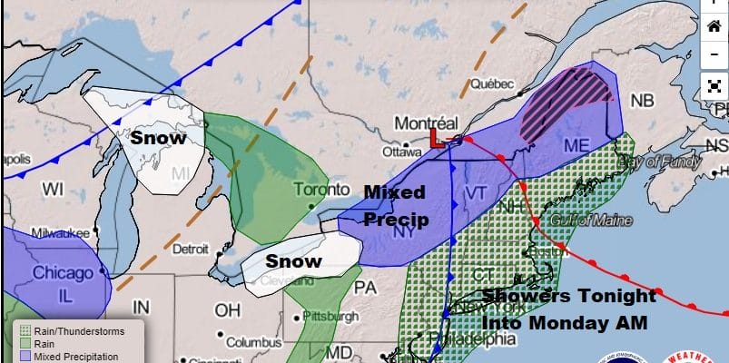
REGIONAL RADAR

Precipitation is showing up on the regional radar to the west where it should remain for most of the day. In parts of Northwest Pennsylvania and Western NY it will be cold enough for some snow. Look for some light showers to start popping up this afternoon on the local radars and then become more numerous tonight.
LOCAL RADAR NEW YORK CITY

LOCAL RADAR PHILADELPHIA


As far as temperatures are concerned for today, they will likely settle in the upper 40s to middle 50s and will depend on how quickly cloud cover takes over. As far as rainfall amounts are concerned from showers tonight, they should be lighter to the west and heavier to the east.

The front is going to slow down as it moves through tonight so there will be some showers still going on tomorrow morning around day break up and down the coast and points east of NYC but to the west it will be all done with before daybreak.

Weather conditions will improve later Monday with decreasing clouds and perhaps some sunshine developing Monday afternoon with highs in the 50s. The week ahead is one where the flow is fast and moving weather systems along from west to east. Chilly air lies in between each system. Another high builds on Tuesday with sunshine but highs just in the 40s.

We have been struggling with the system for the middle of this new week regarding timing. It looks like a cold front will be moving through Wednesday night. Wednesday dayside we will see sunshine and arriving clouds with highs in the 50s. Some showers Wednesday night will last into Thanksgiving morning but most of it should be over with around or after daybreak. Improving weather conditions follow with highs Thursday in the 50s. Friday and Saturday look to be dry with highs in the 50s and then another weather system with another chance for rain next Sunday.
BE SURE TO DOWNLOAD THE FREE METEOROLOGIST JOE CIOFFI WEATHER APP &
ANGRY BEN’S FREE WEATHER APP “THE ANGRY WEATHERMAN!
MANY THANKS TO TROPICAL TIDBITS FOR THE USE OF MAPS
Please note that with regards to any severe weather, tropical storms, or hurricanes, should a storm be threatening, please consult your local National Weather Service office or your local government officials about what action you should be taking to protect life and property.


