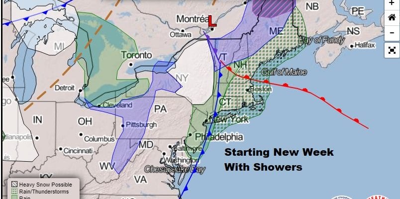
Rain This Morning Improvement Later Today Dry Tuesday into Wednesday Showers Thanksgiving

Weather in 5/Joe & Joe Weather Show Latest Podcast
Rain This Morning Improvement Later Today Dry Tuesday into Wednesday Showers Thanksgiving
We have rain moving through this morning as a cold front is set to pass. This cold front seems to be moving slower than modeled over the last few days and that will probably slow traffic down for weather systems that will follow this week. Clouds are everywhere on the satellite so while we expect weather conditions to improve from west to east later this morning into this afternoon (last to improve along the coast), clearing skies may be hard to come by today.
SATELLITE

REGIONAL RADAR

Radars are busy this morning showing rain with some heavier downpours moving from west to east. We expect the western edge of the rain to reach the coast by 11am or so. Temperatures today will be mostly in the 50s.
LOCAL RADAR NEW YORK CITY

LOCAL RADAR PHILADELPHIA


Tonight we clear out and turn colder with most lows in the 30s. Some 20s are possible inland. Then we have 2 dry days ahead. Tuesday will be a chilly day with sunshine. Highs will be just in the 40s. Wednesday we should see sunshine to start the day but clouds will arrive as we have another situation much like what we saw yesterday into today.

it will be a matter of a warm front trying to move northward with an onshore flow developing ahead of it. Highs Wednesday will be in the 40s north of NYC and in the 50s to the south. Since everything seems to be slowing down by about 6 to 12 hours it looks like Thanksgiving will be cloudy with a few showers. It doesn’t look all that impressive rain wise. Highs Thursday will be in the 50s.

We should have a nice Friday before a weak weather front passes on Saturday with another round of showers possible Highs both days should be in the 50s. After that we will be setting up for low pressure coming out of the rockies and heading toward the Great Lakes and potentially becoming a potent major storm in the process. This likely brings wind windswept downpours here Monday and then it turns colder into the middle of next week.
BE SURE TO DOWNLOAD THE FREE METEOROLOGIST JOE CIOFFI WEATHER APP &
ANGRY BEN’S FREE WEATHER APP “THE ANGRY WEATHERMAN!
MANY THANKS TO TROPICAL TIDBITS FOR THE USE OF MAPS
Please note that with regards to any severe weather, tropical storms, or hurricanes, should a storm be threatening, please consult your local National Weather Service office or your local government officials about what action you should be taking to protect life and property.


