
Weekend Forecast Better Saturday Showers Sunday Night Dry Start to Thanksgiving Week

Weather in 5/Joe & Joe Weather Show Latest Podcast
Weekend Forecast Better Saturday Showers Sunday Night Dry Start to Thanksgiving Week
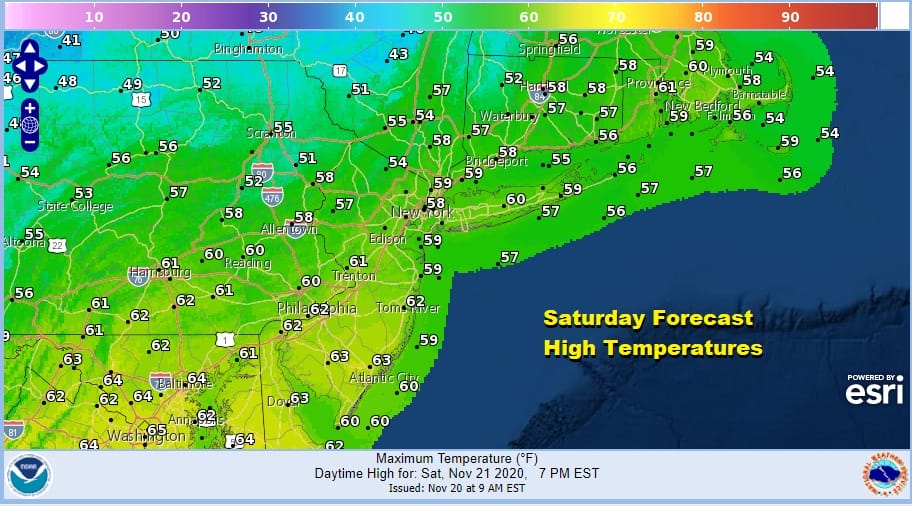
The weekend is underway and we are getting the better day first. We do have a weak cold front that will be moving through today but you will hardly notice it other than a wind shift to the northwest and then to the northeast tonight. We will see a mix of sun and clouds for today. Highs will be in the upper 50s to some lower 60s.
High pressure will be building to our north tonight into Sunday and colder air comes in tonight but temperatures should remain above freezing as lows will be in the upper 30s and lower 40s. Skies will likely should start clear tonight but clouds will be developing late tonight and Sunday morning.
SATELLITE

REGIONAL RADAR

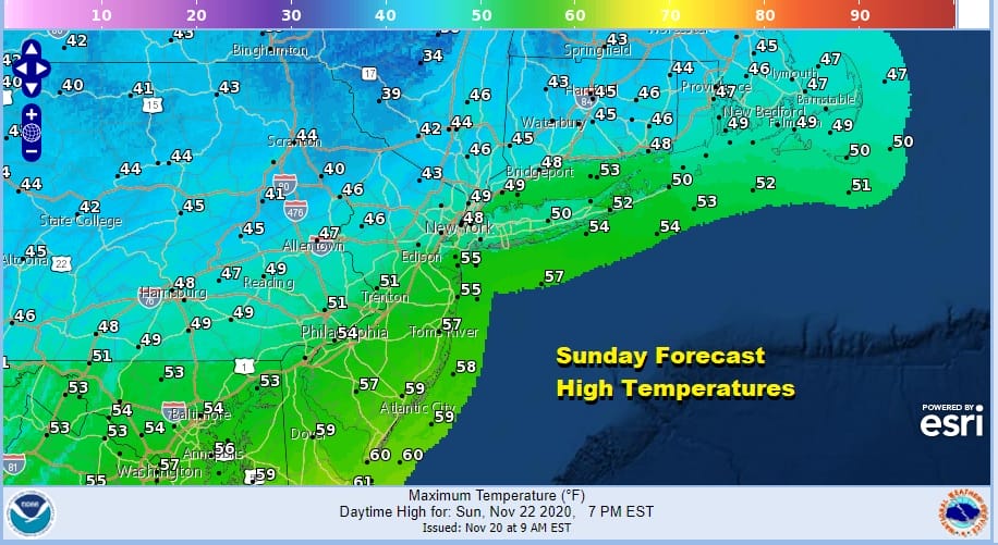
Sunday will be a cloudy raw day thanks to the northeast wind, the high exiting to the east, and today’s cold front which becomes Sunday’s warm front as it comes back northward. There could be a scattered shower or two but for most the day will be dry. Then late today a cold front nears and showers will become more numerous Sunday night.
Once the front passes, weather conditions improve Monday as some sunshine returns. Another chilly high will build to our north and that will bring in chilly air later Monday into Tuesday. Monday’s highs will be in the leftover 50s but we will chill down to the low and middle 30s by Tuesday morning. Tuesday look for plenty of sunshine but highs will be just in the 40s.

We continue to see models struggling a bit with the next storm system coming out of the Central Plains and then heading to the Great Lakes and Southeastern Canada. Models continue to have issues with speed. The latest GFS model has gone back to bringing rain in Wednesday afternoon which means it will be mostly done by Thanksgiving morning but we are still unclear how this ultimately times out. Wednesday look for increasing clouds with highs in the 50s. Rain will come in late in the day and last through at least part of Thursday. The faster it comes in, the faster it goes out. We will update the Thanksgiving outlook as we move through the weekend.
BE SURE TO DOWNLOAD THE FREE METEOROLOGIST JOE CIOFFI WEATHER APP &
ANGRY BEN’S FREE WEATHER APP “THE ANGRY WEATHERMAN!
MANY THANKS TO TROPICAL TIDBITS FOR THE USE OF MAPS
Please note that with regards to any severe weather, tropical storms, or hurricanes, should a storm be threatening, please consult your local National Weather Service office or your local government officials about what action you should be taking to protect life and property.


