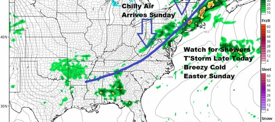
Showers Thunderstorm Possible Today Breezy Chilly Easter Sunday
Wind Rain Monday Night Tuesday

Showers Thunderstorm Possible Today Breezy Chilly Easter Sunday
Wind Rain Monday Night Tuesday
The weekend is underway and we have a cold front approaching today. Clouds are already here and radars are busy around the region showing showers and later today, a few thunderstorms in the mix. However the coverage is not continuous and there will be dry stretches today and even a break or two of sun is not impossible. Highs today will be in the mid 60s to around or just over 70 in some places. I thought there might be a marginal risk for severe weather today with an isolated strong thunderstorm however the Storm Prediction Center is not indicating any sort of risk for the Northeast or Northern Mid Atlantic. They only show a general thunderstorm risk. However I’m going to stick with the idea that there could be an isolated strong storm in the mix.
SATELLITE

WEATHER RADAR

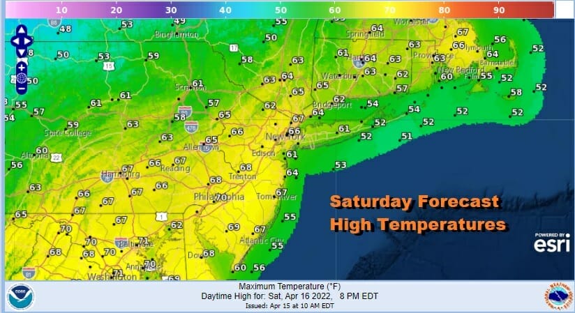
Low pressure develops in Northern New England tonight and Sunday which brings in a gusty northwest wind. Skies will partially clear out tonight with lows in the mid 30s to lower 40s. Easter Sunday will be a blustery chilly day. I’m tempted to call it cold for mid April. We are going to see a mix of sun and clouds thanks to a cold unstable atmosphere. Highs at best will be in the low to mid 50s.

One system moves out and another one moves in Monday. Clouds will be increasing during the day. Monday’s highs will be also just in the low to mid 50s. The air aloft is cold and low pressure comes out of the Tennessee Valley and heads to the Carolinas and then northward up the coast. This is going to be a tight system bringing wind and rain Monday night into Tuesday morning. Some elevated areas in Upstate NY and New England could see some snow out of this as the low moves north. The low exits Tuesday morning so weather conditions should improve somewhat however the air will be cold and unstable and that will likely mean leftover clouds and maybe a leftover shower or two in the afternoon. It might even be a snow shower well inland in the mix. Tuesday highs will be just into the 50s. Wednesday looks dry and temperatures will recover into the 60s followed by another front and a chance for a few scattered showers Thursday.
BE SURE TO DOWNLOAD THE FREE METEOROLOGIST JOE CIOFFI WEATHER APP &
ANGRY BEN’S FREE WEATHER APP “THE ANGRY WEATHERMAN!
MANY THANKS TO TROPICAL TIDBITS & F5 WEATHER FOR THE USE OF MAPS
Please note that with regards to any severe weather, tropical storms, or hurricanes, should a storm be threatening, please consult your local National Weather Service office or your local government officials about what action you should be taking to protect life and property.


