Showers Thunderstorm Possible Overnight
Showers Thunderstorm Possible Overnight
At least for the remainder of the afternoon and into this evening we see no weather issues. The rain from overnight is gone but there is another system crossing the Great Lakes now with a cold front approaching us. Some breaks of sunshine are trying to cut through the clouds in some areas and temperatures are rising into the 60s. The onshore flow has relaxed for the most part except right along the immediate coast.
SATELLITE LOOP

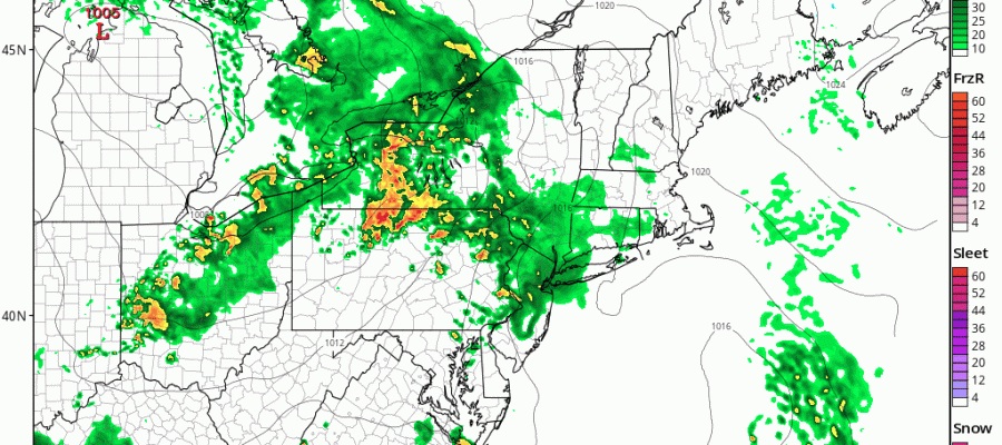
The regional radar is beginning to show more showers and possible thunderstorms developing to the west. They will be affecting parts of our area during the overnight.
REGIONAL RADAR

LOCAL RADAR NEW YORK CITY

LOCAL RADAR PHILADELPHIA


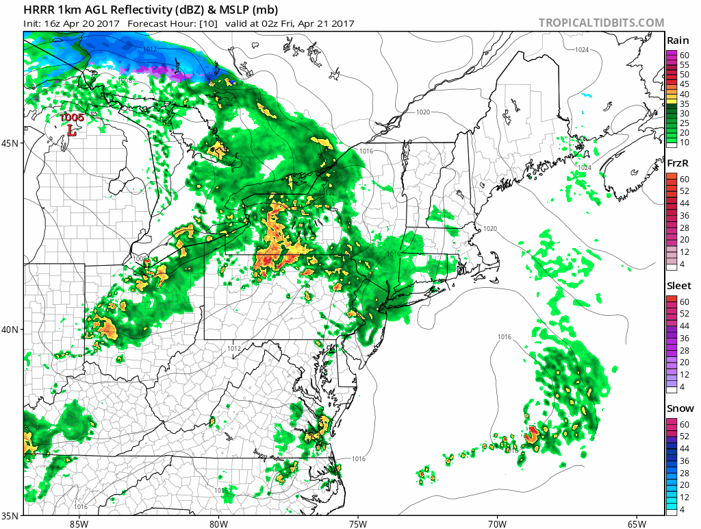
Judging from the latest run of the HRRR model some rain will be moving in late in the evening from the west with a few heavier downpours with a stronger line of showers behind it for the earl morning hours
SHOWERS THUNDERSTORM ON HRRR TONIGHT
Friday will be a tricky day because once the showers are done around daybreak, skies may be slow to clear out. Along the coast the wind off the water plus clouds will probably keep temperatures in the 50s. Inland some breaks of sun are possible later in the day and temperatures there should be in the 60s and some posts could approach 70.
As for the weekend, Saturday is definitely going to be the better of the two weekend days though there may be cloud issues. Saturday night low pressure to the south looks weaker and while some rain could encroach coastal New Jersey and Long Island it may not get much further north than that. An onshore flow Saturday night and Sunday may keep us in clouds and tempertures in the 50s to low 60s regardless. We will explore the weekend complications more later today.
 GET JOE A CIGAR IF YOU LIKE

LANDSCAPE COMPANIES FOR YOUR NEEDS
LONG ISLAND ROCKLAND COUNTY Connecticut

![]()

ROCKLAND COUNTY TRI STATE SNOW REMOVAL JOHNSTOWN PA


FiOS1 News Weather Forecast For Long Island
FiOS1 News Weather Forecast For New Jersey
FiOS1 News Weather Forecast For Hudson Valley
NATIONAL WEATHER SERVICE SNOW FORECASTS
LATEST JOESTRADAMUS ON THE LONG RANGE
Weather App

Don’t be without Meteorologist Joe Cioffi’s weather app. It is really a meteorologist app because you get my forecasts and my analysis and not some automated computer generated forecast based on the GFS model. This is why your app forecast changes every 6 hours. It is model driven with no human input at all. It gives you an icon, a temperature and no insight whatsoever.
It is a complete weather app to suit your forecast needs. All the weather information you need is right on your phone. Android or I-phone, use it to keep track of all the latest weather information and forecasts. This weather app is also free of advertising so you don’t have to worry about security issues with your device. An accurate forecast and no worries that your device is being compromised.
Use it in conjunction with my website and my facebook and twitter and you have complete weather coverage of all the latest weather and the long range outlook. The website has been redone and upgraded. Its easy to use and everything is archived so you can see how well Joe does or doesn’t do when it comes to forecasts and outlooks.
Just click on the google play button or the apple store button on the sidebar for my app which is on My Weather Concierge. Download the app for free. Subscribe to my forecasts on an ad free environment for just 99 cents a month.
Get my forecasts in the palm of your hand for less than the cost of a cup of Joe!


