Showers Some Heavy Downpours Overnight Windy Colder Weekend

Weather in 5/Joe & Joe Weather Show Latest Podcast
Showers Some Heavy Downpours Overnight Windy Colder Weekend
We are about to break our dry streak tonight as a strong storm in the Midwest swings eastward. This storm has a large circulation and is in no hurry to move eastward. In fact the primary low in Eastern Iowa is going to weaken and a secondary low develops to the east. That will enhance a line of showers now moving eastward over the Ohio Valley bringing rain here tonight.
SATELLITE

Ahead of that the day should be dry though there will be clouds around for much of the day. The regional radar that covers New England is quiet for now. The Middle Atlantic states regional radar is picking up on showers to the west in a narrow band as it swings eastward. Temperatures today will be on the warm side with highs in the upper 40s and lower 50s.


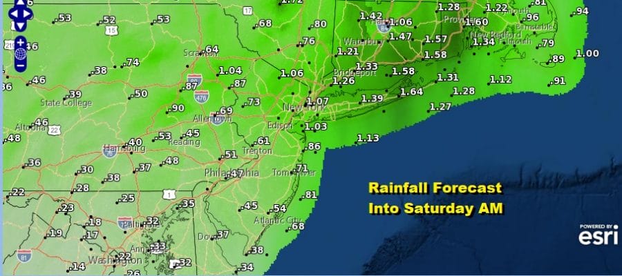
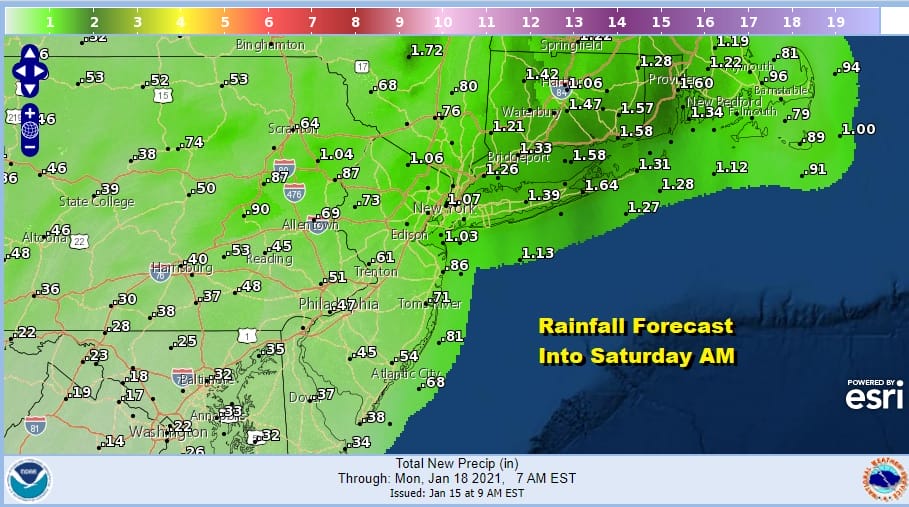
Tonight we will see rain and some locally heavy downpours especially from NYC eastward into New England where a developing wave will enhance the rain overnight. To the west and south of NYC rainfall amounts will be lower. Rainfall amounts south of Philadelphia will be in the order of a quarter to as much as maybe a half inch while east of NYC we are looking at rainfall amounts of an inch and half or more possible.
This morning’s new NAM model shows the front and the developing wave moving to the east Saturday morning. We will see some improvement later Saturday but winds will be picking up from the northwest as the wave takes over and becomes the main storm and strengthens as it heads north.

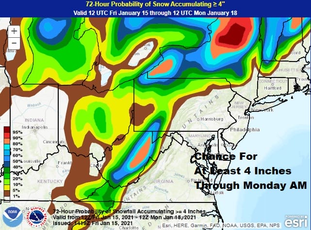
There will be some leftover warmer air around on Saturday so highs will be in the 40s though temperatures may trend lower as the day wears on. This storm system won’t be getting out of the way thanks to the strong block over Greenland so it will remain windy at times right through Sunday and Monday. Along the coastal plains look for clouds and some sun with a gusty wind Sunday and Monday. Highs will be back in the 30s to near 40 both days. Inland however the lake effect snow machine which hasn’t been on much this winter will be turned on and that will produce snow in those lake effect favored areas.
The strong block over Greenland and the Davis Strait shows no signs of letting up anytime soon. Tuesday and Wednesday look to be dry with highs in the 30s to near 40 and lows in the 20s. The next weather system arrives for Thursday but given that there is little room for this storm system to do much, I’m not expecting much to come of this. We will take a look at the long range weather pattern later today.
BE SURE TO DOWNLOAD THE FREE METEOROLOGIST JOE CIOFFI WEATHER APP &
ANGRY BEN’S FREE WEATHER APP “THE ANGRY WEATHERMAN!
MANY THANKS TO TROPICAL TIDBITS FOR THE USE OF MAPS
Please note that with regards to any severe weather, tropical storms, or hurricanes, should a storm be threatening, please consult your local National Weather Service office or your local government officials about what action you should be taking to protect life and property.


