
Showers Arriving Cooler Friday
![]()
The cold front to the north is beginning to move southward and with it we have showers beginning to come into the range of local radars below. Today was another day of record breaking highs across the area.
RECORD HIGH TEMPERATURE LIST
RECORD EVENT REPORT
NATIONAL WEATHER SERVICE NEW YORK NY
1155 AM EST THU MAR 10 2016

...RECORD HIGH TEMPERATURE SET AT CENTRAL PARK NY...

 A RECORD HIGH TEMPERATURE OF 75 DEGREES WAS SET AT CENTRAL PARK NY
TODAY AT 11:55 AM. THIS BREAKS THE OLD RECORD OF 74 SET IN 2006.
THIS REPORT WILL BE UPDATED FURTHER IF TEMPERATURE RISES.
...RECORD HIGH TEMPERATURE SET AT ISLIP NY...

A RECORD HIGH TEMPERATURE OF 72 DEGREES WAS SET AT ISLIP NY
TODAY AT 11:31 AM. THIS BREAKS THE OLD RECORD OF 62 SET IN 2006.
THIS REPORT WILL BE UPDATED IF TEMPERATURES RISE FURTHER.
...RECORD HIGH TEMPERATURE SET AT NEWARK NJ...

 A RECORD HIGH TEMPERATURE OF 77 DEGREES WAS SET AT NEWARK NJ TODAY
AT 11:45 AM. THIS BREAKS THE OLD RECORD OF 76 SET IN 2006.
THIS REPORT WILL BE UPDATED IF TEMPERATURES RISE FURTHER.

...PRELIMINARY RECORD HIGH TEMPERATURE SET AT PHILADELPHIA PA...

 A RECORD HIGH TEMPERATURE OF 80 DEGREES WAS SET AT PHILADELPHIA PA
TODAY. THIS BREAKS THE OLD RECORD OF 76 SET IN 2006.

...PRELIMINARY RECORD HIGH TEMPERATURE SET AT TRENTON NJ...

 A RECORD HIGH TEMPERATURE OF 80 DEGREES WAS SET AT TRENTON NJ
TODAY. THIS BREAKS THE OLD RECORD OF 76 SET IN 2006.

THIS REPORT IS PRELIMINARY. IT`S LIKELY THE TEMPERATURE WILL RISE
FURTHER THIS AFTERNOON. A FINAL REPORT WILL BE ISSUED AROUND 5 PM.
Showers Arriving Cooler Friday Satellite Loops
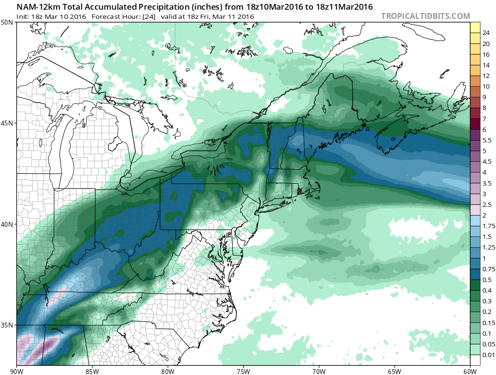
Satellite loop shows the clouds edging southward which effectively cut off the heating in northern areas but it still continues over Southern New Jersey and Southeastern Pennsylvania. The showers coming through tonight should not be a big deal. There might be a few downpours in the mix but it should be gone by daybreak. Rainfall amounts from the NAM model overnight show that the rainfall totals will be under a quarter of an inch.
Weather conditions should improve rapidly Friday with skies becoming partly to mostly sunny. Today is the last day of record temperatures but it will still be rather warm Friday with highs in the upper 50s to lower 60s.


Showers Arriving Cooler Friday Real Time Local Radar Views


Right now Saturday looks good with sunshine and temperatures in the 50s to around 60. Sunday begins an onshore flow as a series of low pressure areas head our way. Im looking for lots of clouds to develop. The Euro model has some spotty rain coming in Sunday afternoon but for now we will just call it Cloudy with highs in the upper 40s to mid 50s. We still seem to be setting up for a soaking rain later Sunday night into Monday and then some more on and off rain through Tuesday night. Here is the total rainfall forecast from the GFS for the next 6 days.
Showers Arriving Cooler Friday GFS RAINFALL TOTALS NEXT 6 DAYS

FiOS1 News Weather Forecast For Long Island
FiOS1 News Weather Forecast For New Jersey
FiOS1 News Weather Forecast For Hudson Valley
NATIONAL WEATHER SERVICE SNOW FORECASTS
LATEST JOESTRADAMUS ON THE LONG RANGE
Weather App

Don’t be without Meteorologist Joe Cioffi’s weather app. It is really a meteorologist app because you get my forecasts and my analysis and not some automated computer generated forecast based on the GFS model. This is why your app forecast changes every 6 hours. It is model driven with no human input at all. It gives you an icon, a temperature and no insight whatsoever.
It is a complete weather app to suit your forecast needs. All the weather information you need is right on your phone. Android or I-phone, use it to keep track of all the latest weather information and forecasts. This weather app is also free of advertising so you don’t have to worry about security issues with your device. An accurate forecast and no worries that your device is being compromised.
Use it in conjunction with my website and my facebook and twitter and you have complete weather coverage of all the latest weather and the long range outlook. The website has been redone and upgraded. Its easy to use and everything is archived so you can see how well Joe does or doesn’t do when it comes to forecasts and outlooks.
Just click on the google play button or the apple store button on the sidebar for my app which is on My Weather Concierge. Download the app for free. Subscribe to my forecasts on an ad free environment for just 99 cents a month.
Get my forecasts in the palm of your hand for less than the cost of a cup of Joe!
![]()
![]()
<