Showers Arriving As Cold Front Passes Snow Chance Wednesday Early Call

Weather in 5/Joe & Joe Weather Show Latest Podcast
Showers Arriving As Cold Front Passes Snow Chance Wednesday Early Call
It is a warm afternoon with temperatures in the mid 50s to around 60 degrees and across Central and South Jersey and points south we are in the low to mid 60s. A cold front is drawing near with a heavier cloud cover and showers which are lined up on the radar across Pennsylvania. This showers will move through late this afternoon and evening. We don’t see any severe weather in this complex so they will come through. Rainfall amounts will be a quarter of an inch or less, and then weather conditions will improve tonight with some partial clearing. Lows will be in the mid 20s to lower 30s.
SATELLITE

WEATHER RADAR

High pressure builds into the Eastern US Tuesday and then rebuilds Tuesday night and Wednesday in New England setting us up in a cold northeast flow. Tuesday highs will be in the 30s to around 40 degrees and then we will head down to the upper 20s and lower 30s Wednesday morning.
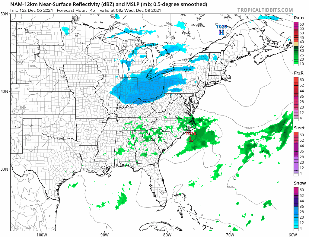
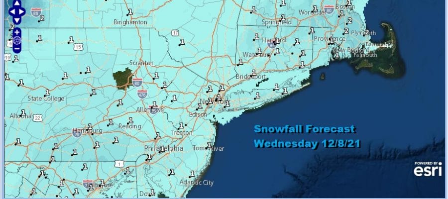
Our front tonight stalls across the south and a wave develops on it as the NAM and other models indicate. The NAM model is way overdone in my view. Snow arrives from west to east Wednesday morning and then ends from west to east later Wednesday afternoon and early evening. I think that at most we are looking at is a slushy coating to perhaps an inch or maybe 2 in some elevated areas. Temperatures Wednesday will be in the middle 30s on average with precipitation intensity determining the air temperature. Patreon Members check the post before this one at 2pm today for more specifics on start and end times, snow amounts, and what models are telling us.
Skies should clear out Wednesday night and it will be cold with lows in the 20s to around 30. Thursday look for sunshine with highs in the 30s to near 40. Thursday night brings a warm front through and the risk for a few showers with steady temps. Friday starts the warm up that takes us through the 40s to near 50. The weekend brings more rain chances as the next weather system heads to Southeastern Canada and another low moves northward up the Appalachians.
BE SURE TO DOWNLOAD THE FREE METEOROLOGIST JOE CIOFFI WEATHER APP &
ANGRY BEN’S FREE WEATHER APP “THE ANGRY WEATHERMAN!

MANY THANKS TO TROPICAL TIDBITS & F5 WEATHER FOR THE USE OF MAPS
Please note that with regards to any severe weather, tropical storms, or hurricanes, should a storm be threatening, please consult your local National Weather Service office or your local government officials about what action you should be taking to protect life and property.


