
Shower Chances Today Tonight
Brisk Chilly Dry Weather Wednesday Into Weekend

Shower Chances Today Tonight
Brisk Chilly Dry Weather Wednesday Into Weekend
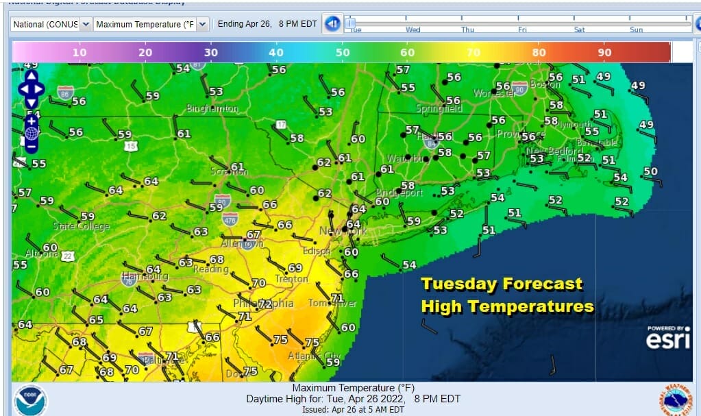
We have a cold front headed our way from the west but judging from what we are seeing on the satellite and radars, this is not all that impressive. We have clouds around today and temperatures are going to struggle in some places but less so in others. From NYC northeast and east highs will be in the upper 50s and lower 60s, while Central and South Jersey and points south and west should reach into the 70s. Watch for some passing showers today as the front goes by. That will be followed by a weak wave of low pressure tonight with some rain. Rainfall amounts this time will be about a quarter of an inch or less.
SATELLITE

WEATHER RADAR

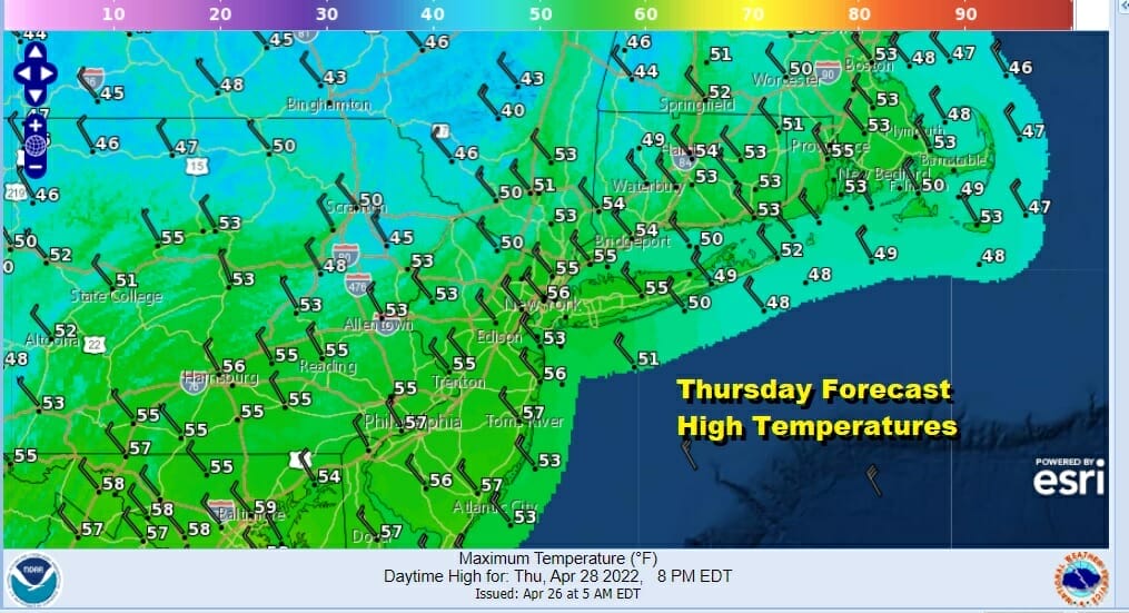
The next 3 days Wednesday through Friday will be more like November weather in late April. A storm developing over Nova Scotia will get stuck there. This leaves us between it and high pressure building into Southeastern Canada. The resulting tight pressure gradient will result in gusty winds of 20 to 30 mph Wednesday through Friday.

At least we will have some sunshine each of the next 3 days. Also the storm system to the northeast is far enough away so that we don’t have big instability issues in the atmosphere as we have seen from time to time lately. Most highs on Wednesday and Thursday will be just in the 50s. Nights will be cold with lows in the upper 20s well inland and 30s just about everywhere else.
Friday will make it a three peat with sunshine, a gusty wind and highs again in the 50s. Heading into the weekend we see the low to the east finally pulling away and allowing for the winds to drop off but we still have a large high to our north slowing down weather systems trying to move west to east across the US.

It does appear that it will be dry through the weekend as enough of that high to the north holds on. We should see plenty of sunshine Saturday and partly sunny skies on Sunday. Highs could may their way back into the 60s. Next week the log jam breaks and weather systems start moving again but we still have blocking issues. This might create more doom and gloom scenarios depending on how lows track and wind direction. Longer range we check every day and there is still no sign of any sustained warmth.
BE SURE TO DOWNLOAD THE FREE METEOROLOGIST JOE CIOFFI WEATHER APP &
ANGRY BEN’S FREE WEATHER APP “THE ANGRY WEATHERMAN!
MANY THANKS TO TROPICAL TIDBITS & F5 WEATHER FOR THE USE OF MAPS
Please note that with regards to any severe weather, tropical storms, or hurricanes, should a storm be threatening, please consult your local National Weather Service office or your local government officials about what action you should be taking to protect life and property.


