Stuck In Clouds Ocean Wind Today Showers Tuesday
Below Average Temperatures Wednesday Through Weekend

Stuck In Clouds Ocean Wind Today Showers Tuesday
Below Average Temperatures Wednesday Through Weekend

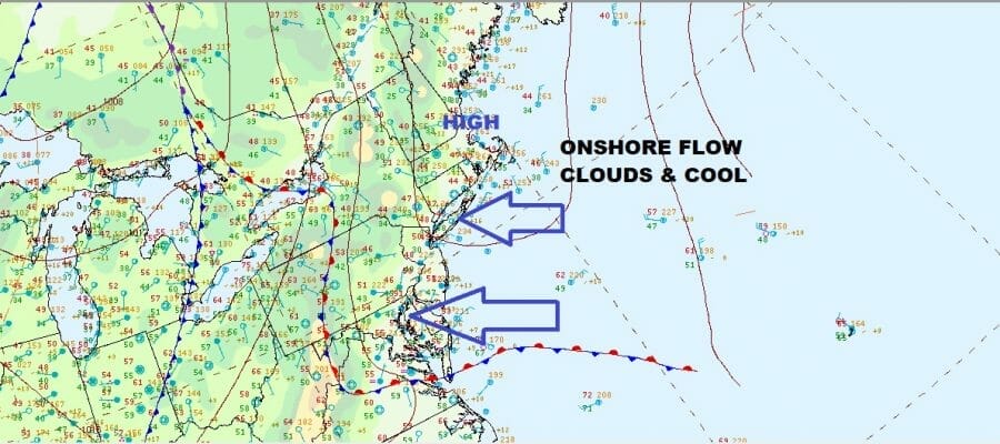
The surface map from earlier this morning and the satellite picture below pretty much tell the story of today. Clouds have shifted southwestward today and cover Eastern Pennsylvania to Long Island and Southwestern Connecticut while it is partly sunny to the northeast of there. The clouds are waiting or the onshore flow to break down but that doesn’t happen until tonight. The remainder of the day we will see temperatures in the 50s with variable clouds and changeable skies but at least from the standpoint of the radar, we have no rain showing up.
SATELLITE

WEATHER RADAR

The onshore flow relaxes tonight so we will see clouds around with temperatures in the 40s to near 50. To the west a cold front approaches Tuesday and there is the chance for some scattered showers during the day as the front passes. Otherwise we will be sitting in clouds and highs in the 60s. The front slows down and a wave brings a few more showers Tuesday night but it should be mostly done by daybreak.

We have been emphasizing a colder than average pattern for the next couple of weeks and we see nothing today that changes that outlook. Looking at the loop of the upper air jet stream pattern this is a classic spring blocking pattern. The first half of spring at least is all about dispersing what is left of cold air in Canada and the Arctic and we have plenty of it. The block keeps the jet stream well to the south of normal in the US and we have a constant feed from Canada for the next couple of weeks.

There is a good side to the block if you are in the right spot with storms to the east and west of you, it could be nice for days at a stretch and Wednesday into the weekend, it seems that we will be in that dry sweet spot with clouds and sun each day. It will be cool though as highs each day through Friday will be in the upper 50s and lower 60s. The weekend will hinge of us holding on to a chilly high before the next weather system approaches. There is a chance we could hold on to the dry weather through Sunday. Next week and beyond it seems that we are evolving into a wetter pattern overall as weather systems move east and pass near or to our south every couple of days. This could mean stretches of gloom and doom are coming but that is in the long range for next week. Other than Tuesday we should be okay Wednesday through Sunday.
BE SURE TO DOWNLOAD THE FREE METEOROLOGIST JOE CIOFFI WEATHER APP &
ANGRY BEN’S FREE WEATHER APP “THE ANGRY WEATHERMAN!
MANY THANKS TO TROPICAL TIDBITS & F5 WEATHER FOR THE USE OF MAPS
Please note that with regards to any severe weather, tropical storms, or hurricanes, should a storm be threatening, please consult your local National Weather Service office or your local government officials about what action you should be taking to protect life and property.


