Severe Weather Risks Ahead Today Wednesday
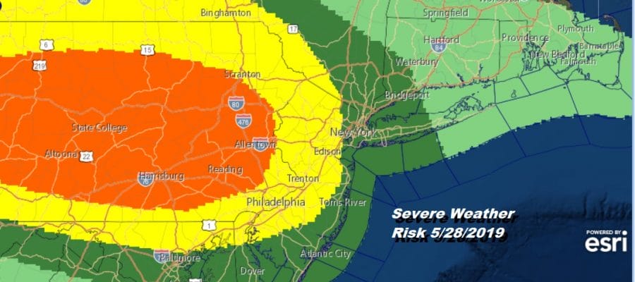
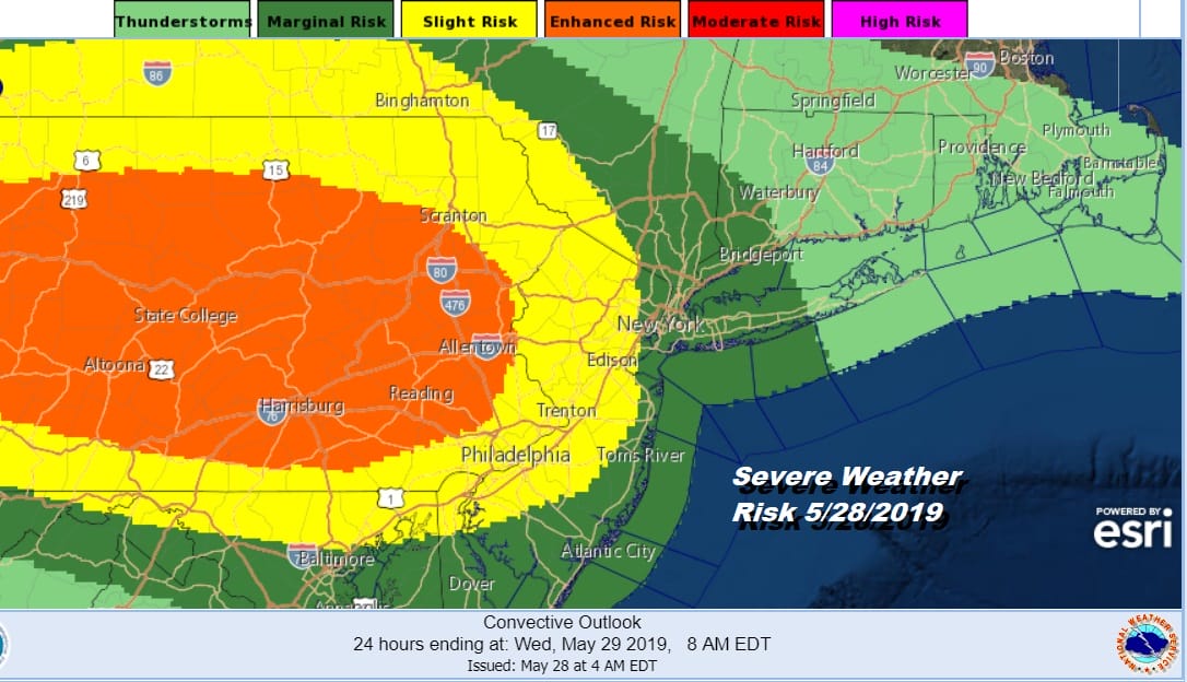
After what was a very good weather weekend we are now watching a frontal boundary to the south that will be buckling back and forth over the next 3 days. This is going to create issues with rain, thunderstorms and the potential for severe weather. In fact the Storm Prediction Center has parts of the area at various risks for severe weather starting with this afternoon into tonight. Slight risk for severe weather reaches NYC and covers all of New Jersey and the Hudson Valley west of the Hudson River. A more aggressive enhanced risk exists for much of Pennsylvania touching the New Jersey state line.
Clouds have been increasing since early this morning and we can see them overhead on the satellite picture. Low pressure is heading across upstate NY with a trailing warm front extending from the low southward into Western Pennsylvania. An onshore flow is setting up to the east which is going to keep temperatures just in the 60s today from NYC north and east with 70s to low 80s from Central New Jersey south and west into Pennsylvania and Delaware.
SATELLITE

REGIONAL RADAR

Rain is approaching on both the regional and local radars and you can look for it to spread from west to east over the next several hours into this afternoon. This is the warm front approaching. Southern Pennsylvania into Maryland we are seeing some heavy thunderstorms moving southeastward.
LOCAL RADAR NEW YORK CITY

LOCAL RADAR PHILADELPHIA


After the first round of rain we are going to see some thunderstorms develop late tonight into this evening and some of those cells could be strong or even severe so we will be watching that closely. After this evening we should see most of the rain and thunderstorms move out with clouds overnight and most lows in the 60s.
Wednesday brings another chance for severe weather but I think much of the day we will see clouds mixed with some sunshine. Highs will reach the 70s along the coast and many inland areas will see highs in the 80s. There is the chance for thunderstorms Wednesday evening but it is a bit early to figure where the best chances for them are other than to say that the risk is there. Much of Wednesday should be rain free.

Thursday brings the last of the lows moving from west to east and this one heads into New England with a cold front coming through Thursday night. Look for some sunshine very warm and humid conditions with most highs in the upper 70s to middle 80s. Depending on how much sun, areas to the south could see readings getting close to 90. The front passes through which sets us up for a nice Friday and a decent start to the weekend. Another weather front approaches Saturday night but this one comes down from the Great Lakes and upstate NY. The weather pattern across the US is changing which will bring some shots of cool air into the East this weekend. This should break the heatwave in the Southeast and bring down some Canadian air for Sunday into Monday. The question of whether there are showers with the front Saturday night is there but the origin of the front suggests a limited amount of moisture so we are optimistic that much of the weekend will be dry.
MANY THANKS TO TROPICAL TIDBITS FOR THE USE OF MAPS
Please note that with regards to any tropical storms or hurricanes, should a storm be threatening, please consult your local National Weather Service office or your local government officials about what action you should be taking to protect life and property.


