Severe Weather Risk Wind Advisory Heavy Rain
SAVE ON PRINCESS CRUISES
Severe Weather Risk Wind Advisory Heavy Rain
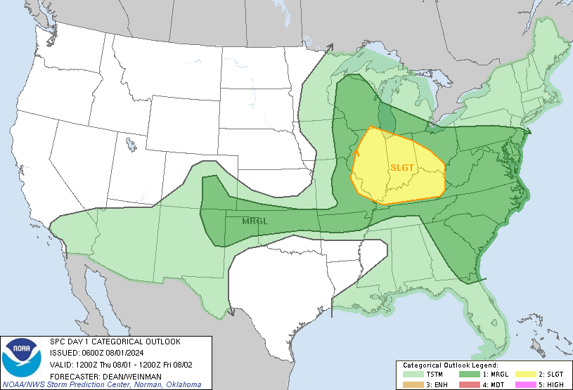
It begins this morning with scattered downpours on the radar and strong gusty winds of 30-40 mph along coastal areas especially. Below is the Storm Prediction Center’s potential risk for severe weather and we are in the zone for slight risk. It is a strong cold front with a narrow band of downpours and thunderstorms that will develop today but it is the slow moving nature of the front that gives us the opportunity for some much needed substantial rains of 1 to 3 inches in most places. It would be a big disappointment if we can’t get at least an inch or two of rain out of this given all the dynamics we have going on today and tonight.
SEVERE WEATHER RISK TUESDAY
SATELLITE LOOP

The satellite loop this morning shows the deep upper trough in the Eastern US with the signature comma shape structure rotating in the lower great lakes. The strong southerly flow aloft prevents much eastward progress of the front itself. Rain on the radar is in a north south band and is patchy in nature at the moment but look for it to increase in coverage as the morning wears on.
REGIONAL RADAR

LOCAL RADAR NEW YORK CITY

LOCAL RADAR PHILADELPHIA


WEATHER OUTLOOK FOR NEW JERSEY EASTERNMOST PENNSYLVANIA
NORTHWARD TO NYC & THE HUDSON VALLEY
We have to break this up today because of the narrow nature of the rain and thunderstorms. Most of the heavy thunderstorm activity and downpours will fall this morning into this evening and begin shifting to the east later this afternoon. Much of the rain in this area will be ending from 4pm to 8pm. Weather conditions will slowly improve overnight and on Wednesday.
FOR SOUTHERN NEW ENGLAND & LONG ISLAND
Here the forecast is a bit tougher. Rain develops later this morning and this afternoon in the Western Half of Connecticut and the Western Half of Long Island but it may take all day or even until tonight for the rains to reach the East End of Long Island and the Eastern half of Connecticut. Rain could still continue into early Wednesday before weather conditions genuinely improve.
WIND ADVISORY IN EFFECT
Gusty winds will be an issue today especially along the coasts with some gusts of 40 mph or higher. Winds will diminish to the west once the front passes by.

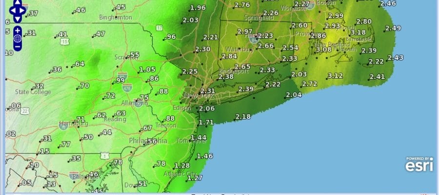
RAINFALL FORECAST

As stated earlier, it will be a huge disappointment if we all can’t get at least an inch or 2 of rain out of this considering all the upper air dynamics at play but as we have been so bone dry for so long it is as if the atmosphere has forgotten how to rain. Nonetheless we should get something decent rain wise from this and some of the heavier thunderstorms could produce some local flooding so be on the looking as travelling today could be a bit treacherous between the rain and the strong winds.
There will be another chance for substantial rain and there could be a tropical connection as low pressure develops in the Northwest Caribbean this weekend. JOESTRADAMUS has more on this.
 GET JOE A CIGAR IF YOU LIKE

FiOS1 News Weather Forecast For Long Island
FiOS1 News Weather Forecast For New Jersey
FiOS1 News Weather Forecast For Hudson Valley


