
Severe Weather Risk Tuesday Rain Wind Cold Front

Severe Weather Risk Tuesday Rain Wind Cold Front
We can see the beginnings of the weather system and cold front out to the west with showers and thunderstorms breaking out from the Southeast US northwestward to the Ohio Valley. This is all from a strong cold front that is headed for the East Coast Tuesday and Wednesday. With a strong upper air disturbance swinging around to the Northeast Tuesday, the Storm Prediction Center has our area at a slight risk for severe thunderstorms.
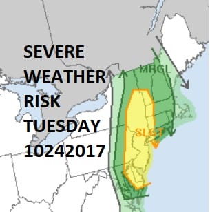
It is a bit unusual to see a risk for severe weather this time of year but then again it is was a bit unusual to have an upper high pressure system sitting overhead for a week with nothing but sunshine. We will manage one more day of at least partly sunny conditions with highs in the 70s today before clouds come in tonight. We could see some spotty light rain or drizzle develop overnight in some places. The front will swing in from the west with rain developing during Tuesday morning from west to east.
The front will be very slow moving and there will be some heavy downpours and thunderstorms that will develop. The slow moving nature of the front will afford us the opportunity to pick up a fairly decent amount of rainfall around the area and the coast may do very well with this rain wise.
NAM RAINFALL FORECAST

We can only hope that the NAM model rainfall forecast above is right but actually all the models are fairly close to this idea with a 1 to 2 inch rainfall for most of the area. Of course this will be thunderstorm driven so there will be some variability in the amounts. Rain will begin to shift offshore by early Wednesday morning but it may take awhile for the downpours to clear the coastline. Much cooler air follows for a dry Thursday and Friday before another front swings in for the weekend.
Long range it is a rather active pattern we have ahead of us with lots of volatility as JOESTRADAMUS points out in his latest long range post.
FiOS1 News Weather Forecast For Long Island
FiOS1 News Weather Forecast For New Jersey
FiOS1 News Weather Forecast For Hudson Valley
NATIONAL WEATHER SERVICE SNOW FORECASTS
LATEST JOESTRADAMUS ON THE LONG RANGE
Weather App

Don’t be without Meteorologist Joe Cioffi’s weather app. It is really a meteorologist app because you get my forecasts and my analysis and not some automated computer generated forecast based on the GFS model. This is why your app forecast changes every 6 hours. It is model driven with no human input at all. It gives you an icon, a temperature and no insight whatsoever.
It is a complete weather app to suit your forecast needs. All the weather information you need is right on your phone. Android or I-phone, use it to keep track of all the latest weather information and forecasts. This weather app is also free of advertising so you don’t have to worry about security issues with your device. An accurate forecast and no worries that your device is being compromised.
Use it in conjunction with my website and my facebook and twitter and you have complete weather coverage of all the latest weather and the long range outlook. The website has been redone and upgraded. Its easy to use and everything is archived so you can see how well Joe does or doesn’t do when it comes to forecasts and outlooks.
Just click on the google play button or the apple store button on the sidebar for my app which is on My Weather Concierge. Download the app for free. Subscribe to my forecasts on an ad free environment for just 99 cents a month.
Get my forecasts in the palm of your hand for less than the cost of a cup of Joe!


