Heavy Rain Severe Weather Strong Winds Tuesday

Heavy Rain Severe Weather Strong Winds Tuesday
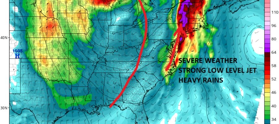
We seem to be seeing reality outperforming weather models today across the South, Ohio Valley, & Midwest today with a very active radar this afternoon. A tornado watch is up for the Western Carolinas as a cold front swings around from the west southwest . This has brought in clouds and higher humidity across the area today but no rain is forecast into the first part of tonight. For now all the radar echos remain to the west and moving northward with just a slight eastward component.

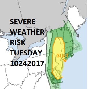
This is going to be a slow moving cold front because of the way the jet stream is set up. The trough is “negatively tilted (northwest southeast) which means that the eastward progress is going to be very slow. This means 2 things. Rain will be slow to move in and slow to move out. Tuesday we have a severe weather threat for most of the area with a slight risk for severe.
Some of the model guidance suggests the strongest thunderstorm activity we have seen even during the summer time. This means that thunderstorms will move into the Eastern half of Pennsylvania & New Jersey tomorrow morning but it may take most of the day to reach coastal areas of Southern New England and Long Island. Conversely the thunderstorms will move out of the western areas first but it may take all night and a good chunch of Wednesday for the rains to clear coastal areas. The result will be a substantial amount of much needed rain for most of the area.
HEAVY RAIN SEVERE WEATHER NAM FORECAST RAINFALL
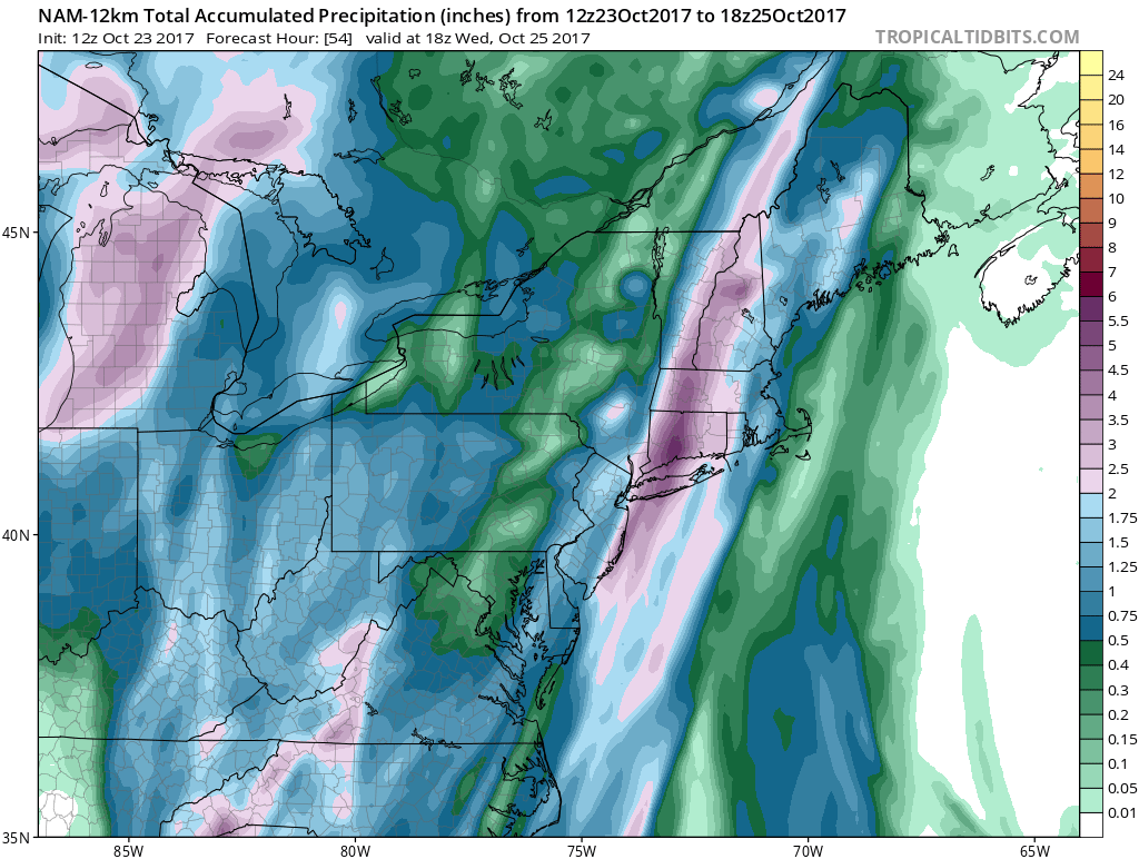
All the models seem to have a bullish outlook for rainfall with the NAM strongly bullish for a band of 2 to 4 inch rainfalls. Given the tropical moisture and the strong dynamics this is certainly possible though we know what happens around here with thunderstorms. This time around we have strong upper level dynamic support so somebody should get clobbered by heavy rains and flash flooding is going to be a distinct possibility especially for coastal areas. With the front slowing down to a crawl, those areas could be especially vunerable to an excessive rainfall.
FiOS1 News Weather Forecast For Long Island
FiOS1 News Weather Forecast For New Jersey
FiOS1 News Weather Forecast For Hudson Valley
NATIONAL WEATHER SERVICE SNOW FORECASTS
LATEST JOESTRADAMUS ON THE LONG RANGE
Weather App

Don’t be without Meteorologist Joe Cioffi’s weather app. It is really a meteorologist app because you get my forecasts and my analysis and not some automated computer generated forecast based on the GFS model. This is why your app forecast changes every 6 hours. It is model driven with no human input at all. It gives you an icon, a temperature and no insight whatsoever.
It is a complete weather app to suit your forecast needs. All the weather information you need is right on your phone. Android or I-phone, use it to keep track of all the latest weather information and forecasts. This weather app is also free of advertising so you don’t have to worry about security issues with your device. An accurate forecast and no worries that your device is being compromised.
Use it in conjunction with my website and my facebook and twitter and you have complete weather coverage of all the latest weather and the long range outlook. The website has been redone and upgraded. Its easy to use and everything is archived so you can see how well Joe does or doesn’t do when it comes to forecasts and outlooks.
Just click on the google play button or the apple store button on the sidebar for my app which is on My Weather Concierge. Download the app for free. Subscribe to my forecasts on an ad free environment for just 99 cents a month.
Get my forecasts in the palm of your hand for less than the cost of a cup of Joe!

MENTION JOE CIOFFI AND GET A 5% DISCOUNT