Severe Weather Risk Northeast NJ Counties to Long Island & New England

Severe Weather Risk Northeast NJ Counties to Long Island & New England
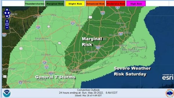
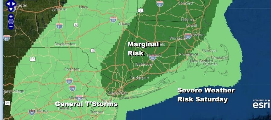
We are starting the Memorial Day holiday weekend on a cloudy note. There are some breaks in the clouds showing up to the west ahead of an upper trough that has to play through today. Skies could brighten up and there could be some short intervals of sunshine but it will likely be of the self destructive variety. The upper trough passes midday into the afternoon with a shower or thunderstorm possible. The Storm Prediction Center has a marginal risk of severe weather across much of New England south to the northeastern counties of New Jersey, the Hudson Valley, NYC, Connecticut and a small portion of Long Island.

Most highs today will be in the mid to upper 70s. Some places could hit 80 degrees. Skies should clear out nicely tonight as the trough moves away to the east and dry air completely takes over. Most lows tonight will be in the mid 50s to lower 60s.
SATELLITE

WEATHER RADAR

Sunday starts a 4 day dry streak with sunshine and progressively warmer temperatures. Humidity levels will be reasonable Sunday though they will come up a bit on Monday. High pressure settles along the South Atlantic coast and it is going to hold until midweek. Highs Sunday will be near or just over 80 degrees in most areas. It might be a little bit cooler at the beaches though the sea breeze will be limited in the coming days.

Monday starts the rise in temperatures. Memorial Day will see sunshine and very warm to hot temperatures. Highs will reach the upper 80s to some lower 90s. Tuesday will be the hottest day of this current stretch. Sunshine will take highs to the low and middle 90s. There won’t be much of a sea breeze this time around as the winds will be mostly west or even northwest and that usually keeps the sea breeze confined to the coast.
Wednesday we have a back door cold front coming in from New England which will turn the wind to the east and keep temperatures much lower. 70s and lower 80s will be common from NYC north and east with mid to upper 80s from Philadelphia south and west. There might be a shower or thunderstorm near the frontal boundary Wednesday afternoon. Thursday sees a cold front with late day showers and thunderstorms coming in from the west. Highs will be back into to 80s. Afterwards we should see improvement Friday and into next weekend..
BE SURE TO DOWNLOAD THE FREE METEOROLOGIST JOE CIOFFI WEATHER APP &
ANGRY BEN’S FREE WEATHER APP “THE ANGRY WEATHERMAN!
MANY THANKS TO TROPICAL TIDBITS & F5 WEATHER FOR THE USE OF MAPS
Please note that with regards to any severe weather, tropical storms, or hurricanes, should a storm be threatening, please consult your local National Weather Service office or your local government officials about what action you should be taking to protect life and property.


