
Severe Weather Risk Marginal As Front Approaches
Severe Weather Risk Marginal As Front Approaches
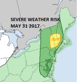
That much of the area is cloudy this morning is hardly a surprise to anyone as we continue to battle the marine layer to the east and the drier air to the west Yesterday we saw the cool marine air penetrate all the way west to Interstate 81 in Eastern Pennsylvania. Thunderstorms could not even make it past that area without falling completely apart. Today the emphasis does shift a little further to the east. The Storm Prediction Center of the National Weather Service is indicating a marginal risk for severe weather today across most of New Jersey, the Hudson Valley, Eastern Pennsylvania, and much of Connecticut except the southeast. Marine air will probably keep severe weather away from Coastal New Jersey & Long Island.
SATELLITE LOOP

REGIONAL RADAR

Satellite and radar loops this morning show lots of clouds and there is a line of showers and a few downpours moving across Eastern Pennsylvania into upstate NY. Much of the area is not experiencing anything with regards to rain at the moment though the threat for showers or a thunderstorm continues today with the best chances later this afternoon and evening as a cold front moves to the coast.
LOCAL RADAR NEW YORK CITY

LOCAL RADAR PHILADELPHIA


Temperatures today are going to be a tough call again depending on whether skies can brighten and we get some sun to develop. Where that happens it will reach the 70s to near 80 and that should be the case from NYC westward while areas to the east may struggle again in the 60s.

Once the front passes tonight we should finally be setting up for 2 decent days. Thursday and Friday should be no worse than partly sunny with highs both days in the 70s to near 80 though it will be cooler at the shore. As far as the weekend is concerned Saturday looks like the better of the two weekend days at this point with some sunshine and temperatures again in the 70s to near 80. Sunday will see clouds and rain developing at some point though there is a question of timing and whether the rain could hold off until later in the day or perhaps Sunday night. We will have more on this later today.
 GET JOE A CIGAR IF YOU LIKE

LANDSCAPE COMPANIES FOR YOUR NEEDS
LONG ISLAND ROCKLAND COUNTY Connecticut

![]()

ROCKLAND COUNTY TRI STATE SNOW REMOVAL JOHNSTOWN PA


FiOS1 News Weather Forecast For Long Island
FiOS1 News Weather Forecast For New Jersey
FiOS1 News Weather Forecast For Hudson Valley
NATIONAL WEATHER SERVICE SNOW FORECASTS
LATEST JOESTRADAMUS ON THE LONG RANGE
Weather App

Don’t be without Meteorologist Joe Cioffi’s weather app. It is really a meteorologist app because you get my forecasts and my analysis and not some automated computer generated forecast based on the GFS model. This is why your app forecast changes every 6 hours. It is model driven with no human input at all. It gives you an icon, a temperature and no insight whatsoever.
It is a complete weather app to suit your forecast needs. All the weather information you need is right on your phone. Android or I-phone, use it to keep track of all the latest weather information and forecasts. This weather app is also free of advertising so you don’t have to worry about security issues with your device. An accurate forecast and no worries that your device is being compromised.
Use it in conjunction with my website and my facebook and twitter and you have complete weather coverage of all the latest weather and the long range outlook. The website has been redone and upgraded. Its easy to use and everything is archived so you can see how well Joe does or doesn’t do when it comes to forecasts and outlooks.
Just click on the google play button or the apple store button on the sidebar for my app which is on My Weather Concierge. Download the app for free. Subscribe to my forecasts on an ad free environment for just 99 cents a month.
Get my forecasts in the palm of your hand for less than the cost of a cup of Joe!


