Severe Weather Risk Expanded Thursday Weekend Outlook & Long Range

Weather in 5/Joe & Joe Weather Show Latest Podcast
Severe Weather Risk Expanded Thursday Weekend Outlook & Long Range
We managed a nice day overall though we are still having some issues with haze and wildfire smoke. Patchy clouds are around in this warm and humid evening and we are seeing a few pop up showers and thunderstorms scattered across Southern Pennsylvania and point southward but they are mostly few and far between.
SATELLITE

Once any of these storms die off skies will be partially clear overnight with some patchy clouds. Temperatures will bottom in the mid 60s to lower 70s as humidity levels remain on the high side.
WEATHER RADAR

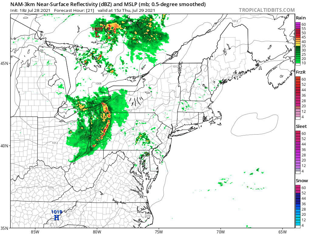
Thursday brings thunderstorms and severe weather risk. We have a strong upper trough and a cold front that will be approaching. Some scattered downpours will pop up during the morning and they will become more numerous in the afternoon and evening. The Storm Prediction Center has the marginal risk zone to Southeastern New England and has pushed the slight risk area to cover all of New Jersey to NYC and Western Long Island.

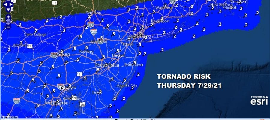
What stands out here is the Tornado Risk with the Storm Prediction Center going now to a rather large 5 percent risk area covering Pennsylvania to most of New Jersey! This means that there is a chance for a tornado within 25 miles of any point in the risk zone. 5 percent may not sound like a high number but we rarely see tornado risk here and even when we do it is usually no higher than 2 percent.

Highest risk time for storms I think will be from mid afternoon through mid evening from west to east so figure between 3pm and 9pm. Some models show some renegade thunderstorms form out ahead of the main line. As always with these set ups, short range map guidance never gets it close to reality. Some of you may not see much and some of you will likely get clobbered with some stronger storms.
All of this turbulence will lead to improving weather conditions on Friday which will start out warm and humid with leftover clouds and then as sunshine develops dew points and humdiity will come crashing down. Highs will be in a range of low to mid 80s. As for the weekend Saturday looks fantastic with sunny skies and highs in the upper 70s to lower 80s. The humidity will be very low and it will be a great day to end what has been a record setting July as far as rain is concerned.
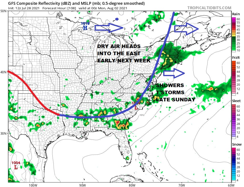
Sunday brings another front and another chance for showers and thunderstorms but not until later in the day. The first part of Sunday should be dry into the early afternoon before the cold front gets close enough to cause some showers and thunderstorms. The humidity will go up Sunday but not by a lot because another high builds in for Monday with dry air. Sunday’s highs will be into the 80s. Monday we should see some sunshine with low humidity again with highs in the mid 70s to around or just over 80 degrees.
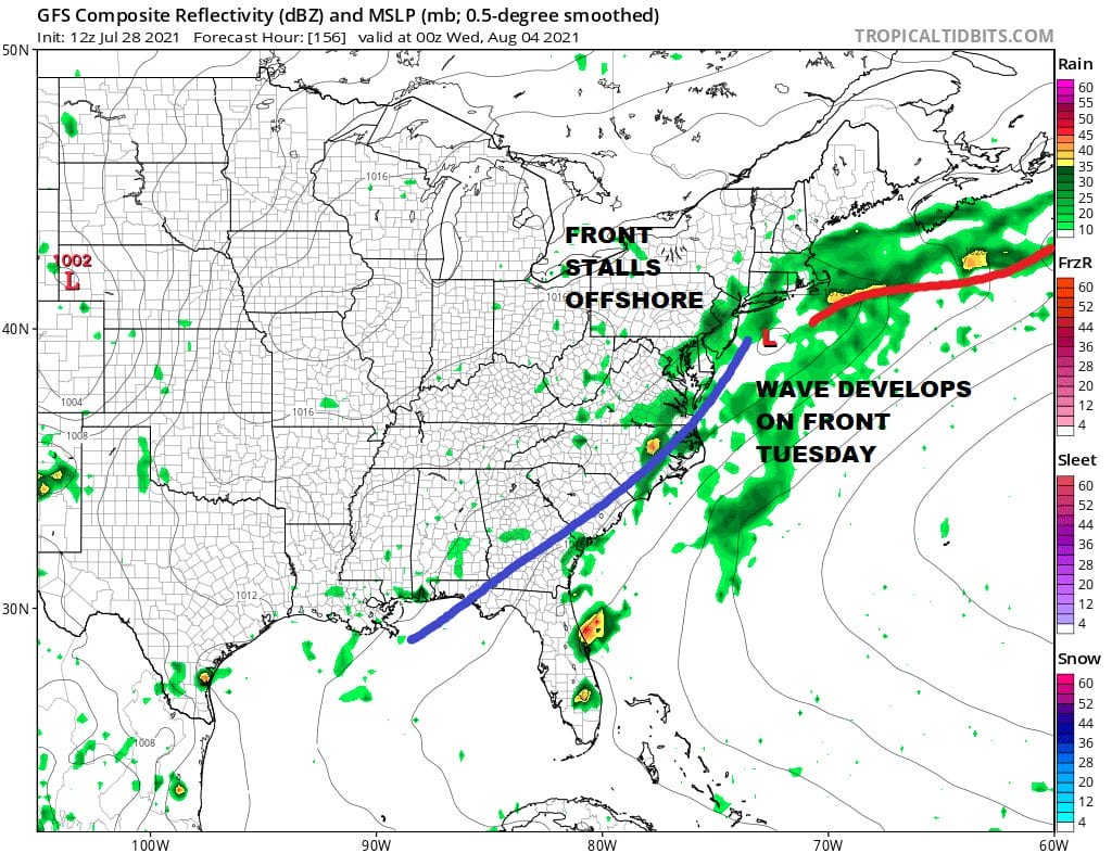
The front stalls offshore and then we start to see a series of waves develop on the front. This is going to be problematic as the upper trough hangs back to the west and creates something of a southerly flow along the coast. Clouds certainly will be an issue and we will have to watch rain moving northward along with how far west the rain shield gets. Does it cut off at the coast or does it works its way well inland? This also means we will be in clouds and a northeast wind and that will keep temperatures in the cooler 60s and 70s in many areas. We could be dealing with this for much of next week if the trough hangs back long enough.
BE SURE TO DOWNLOAD THE FREE METEOROLOGIST JOE CIOFFI WEATHER APP &
ANGRY BEN’S FREE WEATHER APP “THE ANGRY WEATHERMAN!

MANY THANKS TO TROPICAL TIDBITS & F5 WEATHER FOR THE USE OF MAPS
Please note that with regards to any severe weather, tropical storms, or hurricanes, should a storm be threatening, please consult your local National Weather Service office or your local government officials about what action you should be taking to protect life and property.


