Summer Day Very Warm Humid Severe Weather Risk Thursday

Weather in 5/Joe & Joe Weather Show Latest Podcast
Summer Day Very Warm Humid Severe Weather Risk Thursday
We continue our adventure here in late July with another very warm and humid day. The satellite is picking up on a few patchy clouds but we can also see the hazy milky look across much of the Northeast and that continues to be due to the wildfire smoke from the Western US. Notice the difference between the the view in Maine where skies are completely clear verses the area from Southern New England to the Middle Atlantic states. Frontal boundaries are walling off the smoke in some areas but not in others. Temperatures this afternoon should reach the middle to upper 80s though it will be lower as you head into Southern and Southeastern New England.
SATELLITE

We will throw in the chances for a pop up shower or thunderstorm in some isolated spots but for the most part this should be a rain free day. Radars are quiet both locally and regionally and I expect them to remain that way through tonight.
WEATHER RADAR


Thursday marks the next round of important changes. A few things are happening in the atmosphere of note. The flow from Canada will be strengthening as a strong ridge of high pressure starts to build in the west and that results in a corresponding deep trough in the Eastern US. A cold front approaches Thursday into a very warm humid and unstable air mass and that could pose some problems Thursday afternoon and evening.

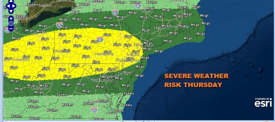
The Storm Prediction Center is indicating a slight risk of severe weather across Pennsylvania and New Jersey for Thursday. It also extends south into Maryland and Northern Delaware. The marginal risk extends all the way east into Southeastern New England.

Going along with this risk zone is a 2 to 5% percent risk for a tornado which is not a regular risk factor around here but the strong upper trough will create areas of wind shear that could create rotation in some thunderstorms.

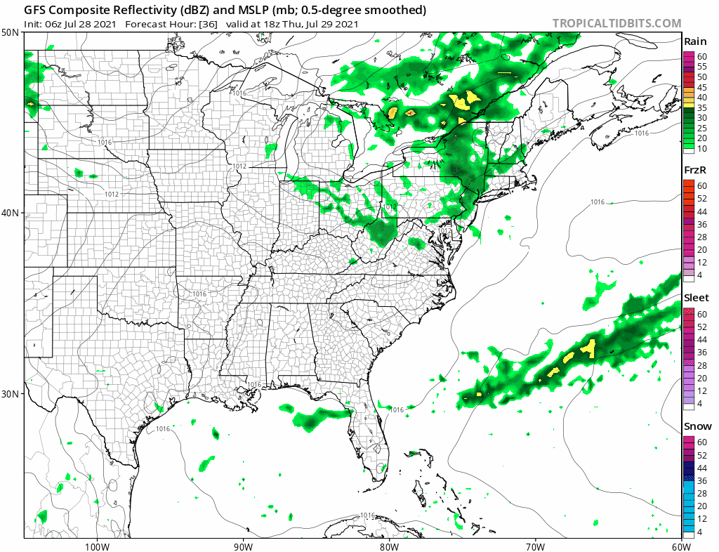
None of the short range models will get this exactly right so the best way to approach this is knowing the risk and watching the radar. The FV3 is one of may possibilities regarding how it plays out. Some renegade showers or thunderstorms will developing into early afternoon and more numerous showers and thunderstorms will develop late in the day into Thursday evening. Because there will be more clouds around Thursday, Highs will be in the upper 70s to near 80 in the marginal risk zone and low to middle 80s in the slight risk zone.
Friday starts the decent into the land of lower humidity and cooler temperatures. It starts with secondary cold front coming through around midday and the the dew points collapse Friday afternoon. Look for clouds early giving way to increasing sunshine later in the day. Highs will be in the 80s but humidity goes way down after the front passes. The weekend looks 50-50. Saturday will be the better of the two days with lots of sunshine cooler temps and low humidity. Highs will be in the upper 70s and lower 80s. Sunday the next cold front arrives with clouds and the chance for showers and thunderstorms. Highs Sunday will be into the 80s. While the humidity comes up some, it doesn’t shoot up to anything too uncomfortable.
BE SURE TO DOWNLOAD THE FREE METEOROLOGIST JOE CIOFFI WEATHER APP &
ANGRY BEN’S FREE WEATHER APP “THE ANGRY WEATHERMAN!

MANY THANKS TO TROPICAL TIDBITS & F5 WEATHER FOR THE USE OF MAPS
Please note that with regards to any severe weather, tropical storms, or hurricanes, should a storm be threatening, please consult your local National Weather Service office or your local government officials about what action you should be taking to protect life and property.


