Severe Weather Risk 03012017
Severe Weather Risk 03012017
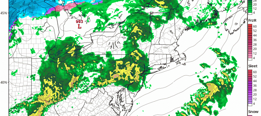
The Storm Prediction Center of the National Weather Service continues to keep much of our area ni a slight risk for severe weather today with an enhanced risk indicated for parts of South Central Pennsylvania west and southward. You can see the risk area outlined on the map below along with the latest real time radar.

There are two areas to consider on the radar this morning. The first is approaching and will be moving through around mid morning. The second will be a line of thunderstorms that forms early afternoon in Pennsylvania and then heads across New Jersey toward Long Island between 2-5pm.


In between all this we have the prospect of temperatures heading into the 60s and 70s with record highs being achieved. Along the coast the severe thunderstorm threat will hinge on the southwest verses southeast wind and which one wins out. The cold ocean is a thunderstorm killer so wind direction will be critical.
SEVERE WEATHER THREAT HRRR MODEL 10AM-4PM

Once the second line of thunderstorms is done weather conditions should improve as a cold front moves offshore tonight. Thursday will be dry and colder with temperatures in the 40s. Then it looks like a period of snow for Friday is likely for some areas as even colder air arrives and a little wave develops on a cold front. We will have more on this and the prospects for accumulations later this morning.
FiOS1 News Weather Forecast For Long Island
FiOS1 News Weather Forecast For New Jersey
FiOS1 News Weather Forecast For Hudson Valley
NATIONAL WEATHER SERVICE SNOW FORECASTS
LATEST JOESTRADAMUS ON THE LONG RANGE
Weather App

Don’t be without Meteorologist Joe Cioffi’s weather app. It is really a meteorologist app because you get my forecasts and my analysis and not some automated computer generated forecast based on the GFS model. This is why your app forecast changes every 6 hours. It is model driven with no human input at all. It gives you an icon, a temperature and no insight whatsoever.
It is a complete weather app to suit your forecast needs. All the weather information you need is right on your phone. Android or I-phone, use it to keep track of all the latest weather information and forecasts. This weather app is also free of advertising so you don’t have to worry about security issues with your device. An accurate forecast and no worries that your device is being compromised.
Use it in conjunction with my website and my facebook and twitter and you have complete weather coverage of all the latest weather and the long range outlook. The website has been redone and upgraded. Its easy to use and everything is archived so you can see how well Joe does or doesn’t do when it comes to forecasts and outlooks.
Just click on the google play button or the apple store button on the sidebar for my app which is on My Weather Concierge. Download the app for free. Subscribe to my forecasts on an ad free environment for just 99 cents a month.
Get my forecasts in the palm of your hand for less than the cost of a cup of Joe!

MENTION JOE CIOFFI AND GET A 5% DISCOUNT