Severe Weather Record Highs Wednesday
Severe Weather Record Highs Wednesday
We begin the new week with some sunshine this morning but there are clouds building up to the south across the lower Ohio Valley as the next storm gets ready to develop in the Great Lakes. Clouds will start to arrive later this morning and this afternoon but I don’t think we will see any showers during the day to day. Temperatures are in the chilly 30s but they will rise into and through the 40s in most places this afternoon.
SATELLITE LOOP

REGIONAL RADAR

LOCAL RADAR NEW YORK CITY

LOCAL RADAR PHILADELPHIA


Since the warm front is setting up to our north I don’t foresee any showers of consequence until maybe late Tuesday afternoon or Tuesday evening as temperatures continue to rise. Tuesday’s highs will be in the 50s to near 60 degrees except reaching the 60s across the southern half of New Jersey and Southeastern Pennsylvania southward.
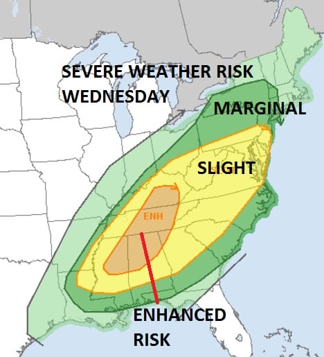
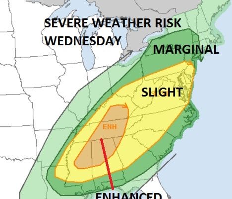
Wednesday we see a repeat of Saturday which means temperatures reaching the 70s and record highs along with the chance for severe weather again late in the day and Wednesday evening. It appears at the moment that it could be as widespread as it was on Saturday and the latest forecast outlook from the Storm Prediction Center of the National Weather Service has expanded the area of severe weather further north for Wednesday. Once this cold front passes it will turn sharply colder for the rest of the week and there is even the chance for a period of snow or flurries Thursday night into Friday morning in some areas.
As far as the long range is concerned here is the latest from JOESTRADAMUS.
 GET JOE A CIGAR IF YOU LIKE

SNOW REMOVAL COMPANIES FOR YOUR WINTER NEEDS
LONG ISLAND ROCKLAND COUNTY Connecticut

![]()

ROCKLAND COUNTY TRI STATE SNOW REMOVAL JOHNSTOWN PA


FiOS1 News Weather Forecast For Long Island
FiOS1 News Weather Forecast For New Jersey
FiOS1 News Weather Forecast For Hudson Valley
NATIONAL WEATHER SERVICE SNOW FORECASTS
LATEST JOESTRADAMUS ON THE LONG RANGE
Weather App

Don’t be without Meteorologist Joe Cioffi’s weather app. It is really a meteorologist app because you get my forecasts and my analysis and not some automated computer generated forecast based on the GFS model. This is why your app forecast changes every 6 hours. It is model driven with no human input at all. It gives you an icon, a temperature and no insight whatsoever.
It is a complete weather app to suit your forecast needs. All the weather information you need is right on your phone. Android or I-phone, use it to keep track of all the latest weather information and forecasts. This weather app is also free of advertising so you don’t have to worry about security issues with your device. An accurate forecast and no worries that your device is being compromised.
Use it in conjunction with my website and my facebook and twitter and you have complete weather coverage of all the latest weather and the long range outlook. The website has been redone and upgraded. Its easy to use and everything is archived so you can see how well Joe does or doesn’t do when it comes to forecasts and outlooks.
Just click on the google play button or the apple store button on the sidebar for my app which is on My Weather Concierge. Download the app for free. Subscribe to my forecasts on an ad free environment for just 99 cents a month.
Get my forecasts in the palm of your hand for less than the cost of a cup of Joe!


