Rollercoaster Ride Begins Records Severe TStorms Snow
Rollercoaster Ride Begins Records Severe TStorms Snow
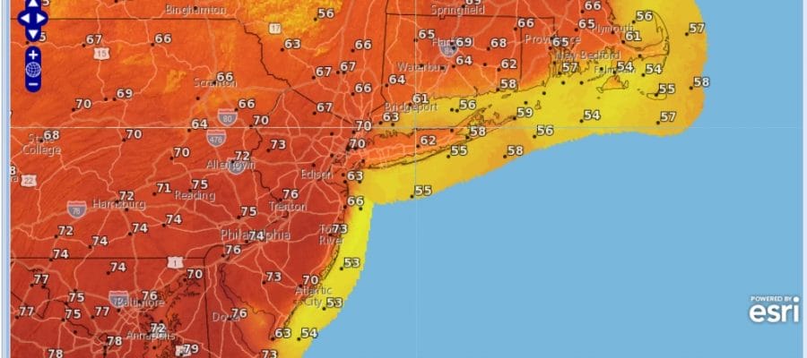
The rollercoaster ride begins as we will be seeing temperatures rise over the next 48 hours. Wednesday afternoon much of the area will be sitting in the 70s with records highs getting shattered. Low pressure over the Eastern Great Lakes and its associated strong cold front will then trigger off another round of severe thunderstorms for much of the Middle Atlantic and Southern areas of the Northeast which include NYC, Hudson Valley, Long Island, New Jersey & Pennsylvania. This will be the second widespread outbreak in 4 days and very rare for this early in the severe storms season.
RECORD HIGH TEMPERATURES POSSIBLE WEDNESDAY
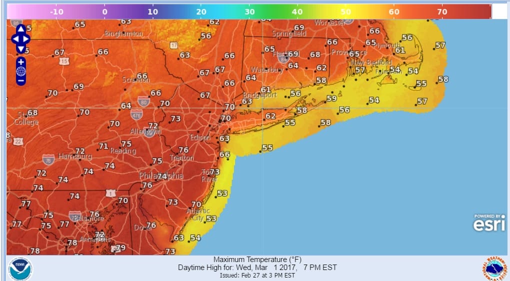
The leading edge of that warm air is arriving now aloft in the form of clouds and they will be with us tonight with temperatures not falling very far. Most lows will be in the upper 30s and lower 40s. Then as the winds begin to go south and then southwest on Tuesday look for more clouds and rising temperatures through the 50s and into the 60s in some places. Tuesday evening when the warm front moves through, there will be some downpours and perhaps even a few thunderstorms in the mix. Then in comes the very warm air and the setup for severe weather late Wednesday into Wednesday night. Not much will happen on Wednesday as we will have clouds and some sunshine. Less of a marine influence could mean that even coastal areas may see some strong thunderstorms this time around.
SATELLITE LOOP

REGIONAL RADAR

LOCAL RADAR NEW YORK CITY

LOCAL RADAR PHILADELPHIA


Radars are showing some rain aloft and much of it is evaporating before it reaches the ground. We will probably see these echos for awhile tonight but little should come of it.
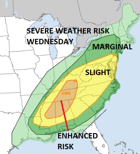
There are no changes in the Storm Prediction Center’s forecast from earlier today. At the moment the main threat for severe weather will come late Wednesday afternoon into Wednesday night..then colder air follows for Thursday with most highs in the 40s. A weak area of low pressure will swing out of the Great Lakes and that could bring a period of snow here Friday morning. Right now the low appears weak and even if it snows, it would probably not accumulate on road surfaces.
 GET JOE A CIGAR IF YOU LIKE

SNOW REMOVAL COMPANIES FOR YOUR WINTER NEEDS
LONG ISLAND ROCKLAND COUNTY Connecticut

![]()

ROCKLAND COUNTY TRI STATE SNOW REMOVAL JOHNSTOWN PA


FiOS1 News Weather Forecast For Long Island
FiOS1 News Weather Forecast For New Jersey
FiOS1 News Weather Forecast For Hudson Valley
NATIONAL WEATHER SERVICE SNOW FORECASTS
LATEST JOESTRADAMUS ON THE LONG RANGE
Weather App

Don’t be without Meteorologist Joe Cioffi’s weather app. It is really a meteorologist app because you get my forecasts and my analysis and not some automated computer generated forecast based on the GFS model. This is why your app forecast changes every 6 hours. It is model driven with no human input at all. It gives you an icon, a temperature and no insight whatsoever.
It is a complete weather app to suit your forecast needs. All the weather information you need is right on your phone. Android or I-phone, use it to keep track of all the latest weather information and forecasts. This weather app is also free of advertising so you don’t have to worry about security issues with your device. An accurate forecast and no worries that your device is being compromised.
Use it in conjunction with my website and my facebook and twitter and you have complete weather coverage of all the latest weather and the long range outlook. The website has been redone and upgraded. Its easy to use and everything is archived so you can see how well Joe does or doesn’t do when it comes to forecasts and outlooks.
Just click on the google play button or the apple store button on the sidebar for my app which is on My Weather Concierge. Download the app for free. Subscribe to my forecasts on an ad free environment for just 99 cents a month.
Get my forecasts in the palm of your hand for less than the cost of a cup of Joe!


