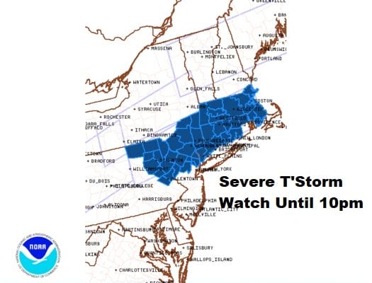
Severe Thunderstorm Watch Until 10PM Northeast Pa
Northern NJ Hudson Valley Southern New England

Weather in 5/Joe & Joe Weather Show Latest Podcast
Severe Thunderstorm Watch Until 10PM Northeast Pa
Northern NJ Hudson Valley Southern New England
Highs today reached 100 degrees or close to it in many areas. Dew points are all above 70. An upper trough is approaching, and a slow moving cold front. That all adds up to severe weather potential and we have a Severe Thunderstorm Watch posted from Northeastern Pennsylvania to Southern New England.

CONNECTICUT COUNTIES INCLUDED ARE
FAIRFIELD HARTFORD LITCHFIELD
MIDDLESEX NEW HAVEN NEW LONDON
TOLLAND WINDHAM
MASSACHUSETTS COUNTIES INCLUDED ARE
BERKSHIRE BRISTOL ESSEX
FRANKLIN HAMPDEN HAMPSHIRE
MIDDLESEX NORFOLK PLYMOUTH
SUFFOLK WORCESTER
NEW JERSEY COUNTIES INCLUDED ARE
BERGEN MORRIS PASSAIC
SUSSEX WARREN
NEW YORK COUNTIES INCLUDED ARE
COLUMBIA DUTCHESS GREENE
ORANGE PUTNAM ROCKLAND
SULLIVAN ULSTER WESTCHESTER
PENNSYLVANIA COUNTIES INCLUDED ARE
BRADFORD CARBON LACKAWANNA
LEHIGH LUZERNE MONROE
NORTHAMPTON PIKE SUSQUEHANNA
WAYNE WYOMING
RHODE ISLAND COUNTIES INCLUDED ARE
PROVIDENCE
SATELLITE

The satellite picture shows cloud free conditions and these storms won’t get close for another couple of hours. They will be racing against sunset. Once the daytime heating gets cut off, these storms should start to weaken as they move east. Strong gusty winds of 50 knots or higher are possible in stronger storms.
WEATHER RADAR


While the extreme heat ends to day, the humidity does not. It continues tomorrow and there will be another round of thunderstorms that could produce heavy rains later Thursday into Thursday night. Severe weather risk continues on Thursday.

The risk area does shift southward Thursday with higher risk areas in Southern New Jersey to about NYC and Western Long Island but this area could be extended and nudged further north. Heavy rain could be the bigger issues Thursday into Friday with amounts of 2 inches or more possible. Additional rain is likely into early Friday.

We still remain cautiously optimistic that weather conditions will improve as we move through the weekend. Saturday could be a housecleaning day of leftover clouds but there may be some sun in the mix along with scattered showers. An upper trough needs to move through. Temperatures and humidity will be down Friday through Sunday. Daytime highs will be in the 70s and nights will be in the 50s to lower 60s. Sunday looks to be a partly sunny day and Monday looks mostly sunny. Temperatures Monday will be back into the 80s.
BE SURE TO DOWNLOAD THE FREE METEOROLOGIST JOE CIOFFI WEATHER APP &
ANGRY BEN’S FREE WEATHER APP “THE ANGRY WEATHERMAN!

MANY THANKS TO TROPICAL TIDBITS & F5 WEATHER FOR THE USE OF MAPS
Please note that with regards to any severe weather, tropical storms, or hurricanes, should a storm be threatening, please consult your local National Weather Service office or your local government officials about what action you should be taking to protect life and property.


