Severe Weather Risks Flash Flood Watch New Jersey
July 4th Holiday Weekend Outlook

Weather in 5/Joe & Joe Weather Show Latest Podcast
Severe Weather Risks Flash Flood Watch New Jersey
July 4th Holiday Weekend Outlook
The heatwave is over with as we will not be hitting the 90s to near 100 degrees today. Instead most temperatures will be in the upper 70s to middle 80s for highs. It remains very humid as a very slow moving cold front sits overhead. That poses problems for later today and tonight.
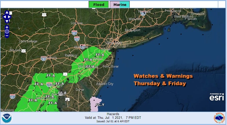
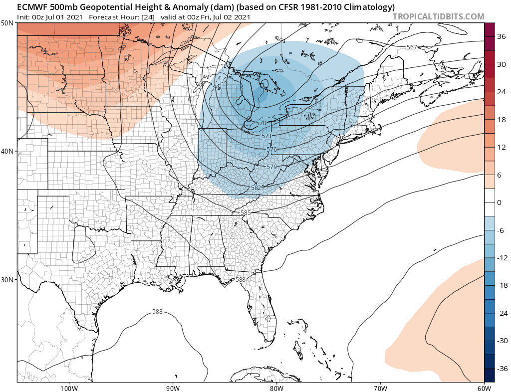
Let’s begin with watches and we have Flash Flood Watches up for parts of Central and South Jersey mainly south of Route 78 and northwest of the NJ Turnpike. Flash Flood Watches are alo s posted for parts of Southeast Pennsylvania, Delaware and Maryland.
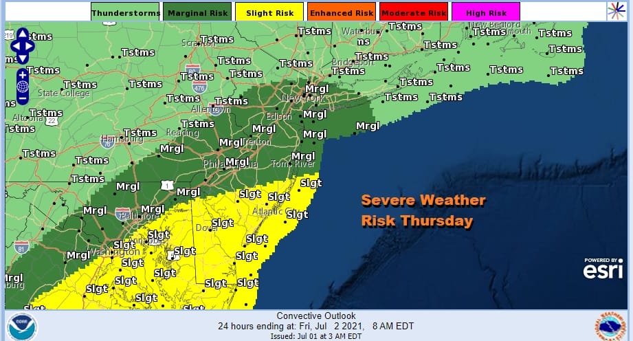
We also have severe weather risk today with the front lying just west of the coast and warm tropical air pushing northward. Marginal to slight risk is indicated with the main threat from this being heavy rains and gusty winds.

As we move through the day the clouds to the northwest will sink southeast and we will start to see rain develop during the midday to early afternoon hours. Then we will throw in developing thunderstorms and the table is set for some very heavy downpours.
SATELLITE

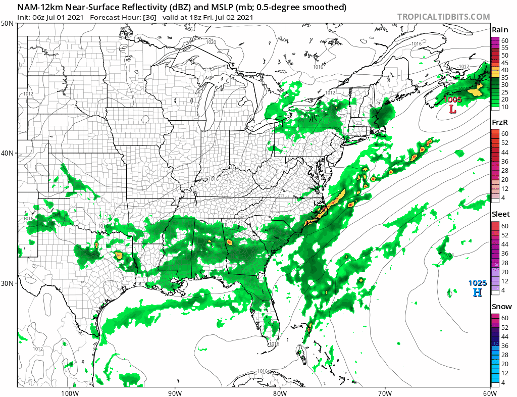
Activity on the radar is mostly to the northwest of the coast this morning and on the regional radar the leading edge of rain runs from northeast to southwest in Pennsylvania and moving eastward.
WEATHER RADAR


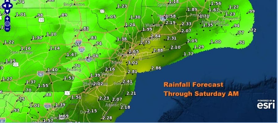
The main threat as we noted is heavy rain and the potential for localized flash flooding. This is one of those instances where someone is going to get underneath a cluster of thunderstorms and get clobbered with several inches of rain or more. On average we will see a band of 2 to 3 inches of rain setting up.

Rain will continue overnight into Friday morning daybreak before becoming more showery and scattered in nature. Otherwise Friday will be a cloudy day. Highs will be just in the 70s. One last low pressure area will develop on the front later Friday and Friday night and move northeastward. That should finally take the frontal boundary far enough offshore that we can start the slow road to improvement.
Saturday will probably be a day where we will be dealing with lots of leftover clouds. North and east of NYC highs will be just in the 60s while everywhere else temperatures should reach the 70s. The further south and west you go toward Philadelphia, Baltimore & Washington DC for example you may see some breaks of sun and therefore higher temperatures.

There also will be an upper trough moving through and we can’t rule out the possibility of scattered showers. The trough will be moving east and offshore Saturday night into Sunday and that will strengthen the northerly flow up and down the East Coast over the weekend.
Beginning during the day Friday and lasting into Monday will be a significant lower of the humidity once again as dew points head into the upper 40s and lower 50s. Sunday should be a nice day overall with no worse than a mix of sun and clouds. We will leave in the outside chance for an isolated shower. Highs will be in the pleasant 70s to near 80.
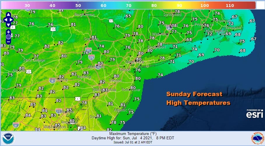
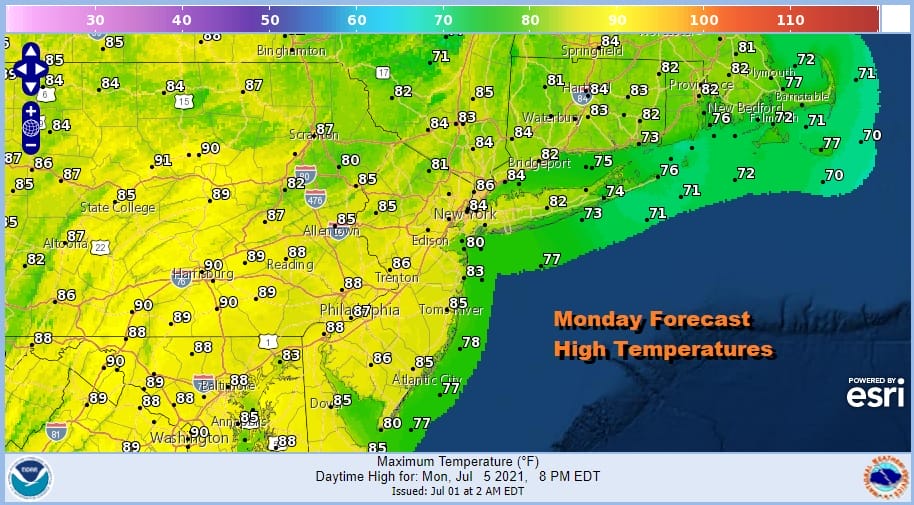
July 4th fireworks shows on Sunday should have no issues and operate under a clear sky and conditions of reasonable humidity and temperatures. Monday caps the three day weekend with sunshine and warmer temperatures. Humidity levels will come up but it will be reasonable. Highs will be back to the mid to upper 80s.
Hot weather likely returns Tuesday and Wednesday with sunshine both days and highs reaching into the 90s. Humidity levels will be back up as dew points head for 70. Another cold front will be approaching by later Wednesday so we will throw in the chance for a thunderstorm. Over the weekend we will also be keeping an eye on Tropical Storm Else which developed overnight east of the Leeward Islands. It is headed westward for now and we will see what lies ahead once it enters the Eastern Caribbean Sea.
BE SURE TO DOWNLOAD THE FREE METEOROLOGIST JOE CIOFFI WEATHER APP &
ANGRY BEN’S FREE WEATHER APP “THE ANGRY WEATHERMAN!

MANY THANKS TO TROPICAL TIDBITS & F5 WEATHER FOR THE USE OF MAPS
Please note that with regards to any severe weather, tropical storms, or hurricanes, should a storm be threatening, please consult your local National Weather Service office or your local government officials about what action you should be taking to protect life and property.


