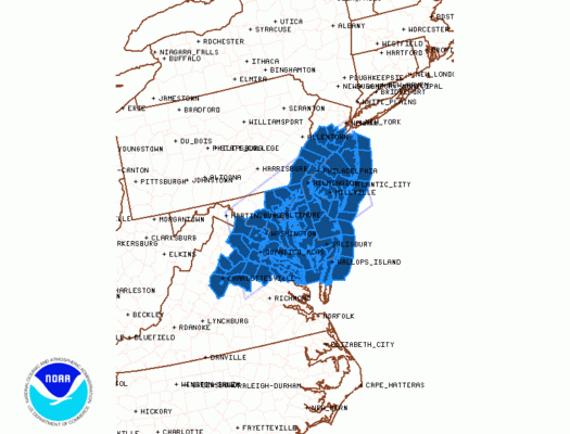
Severe Thunderstorm Watch Posted Most of New Jersey
Southern Pennsylvania Maryland Delaware
NEW JERSEY COUNTIES INCLUDED ARE
ATLANTIC BURLINGTON CAMDEN
CAPE MAY CUMBERLAND GLOUCESTER
HUNTERDON MERCER MIDDLESEX
MONMOUTH OCEAN SALEM
SOMERSET
PENNSYLVANIA COUNTIES INCLUDED ARE
BUCKS CHESTER DELAWARE
MONTGOMERY PHILADELPHIA
DELAWARE COUNTIES INCLUDED ARE
KENT NEW CASTLE SUSSEX
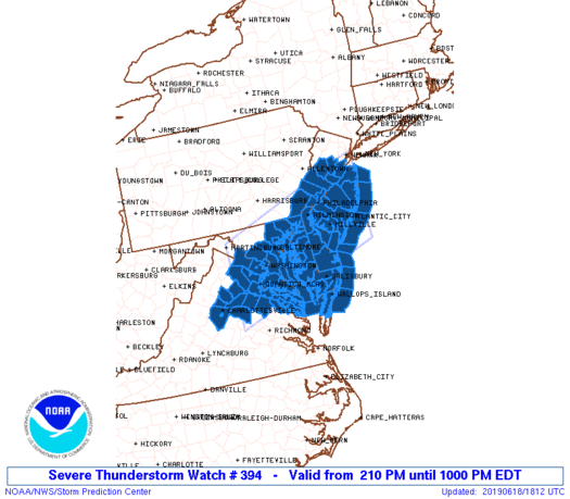
North of the frontal boundary that won’t go away, heavy rains have produced flash flooding over parts of Central New Jersey, the area of rain responsible for that continues to plod slowly eastward across Southern New England and Long Island. While all this has been going on the southern half of New Jersey has seen temperatures climb into the 80s again. This area has been getting the daytime heating again and the Storm Prediction Center has responded with a severe thunderstorm watch for Central & South Jersey, Southern Pennsylvania, Maryland and Delaware.
SATELLITE

The National Weather Service in Mount Holly NJ has issued a
* Flash Flood Warning for…
North central Mercer County in central New Jersey…
Southern Somerset County in northern New Jersey…
Central Middlesex County in northern New Jersey…
* Until 545 PM EDT.
* At 151 PM EDT, Doppler radar indicated thunderstorms producing
heavy rain across the warned area. Up to one inch of rain has
already fallen. Flash flooding is expected to begin shortly in the
areas of heaviest rain.
* Some locations that could experience flooding include…
New Brunswick, Somerset, Edison, Old Bridge, East Brunswick, South
Brunswick, Sayreville, North Brunswick, Princeton, Matawan,
Jamesburg, Hopewell, Rocky Hill, Skillman, Brownville, Kingston,
Dayton, Plainsboro Center, North Brunswick Township and Kendall
Park.
REGIONAL RADAR

Radars are showing the tail of the area of rain moving east across Southern New England producing very heavy rains. Separate from this are showers starting to rev up in Northern Virginia and Southern Pennsylvania. From this are we will see thunderstorms develop going into this evening. Some of these thunderstorms will be capable of producing damaging winds and heavy rains.
LOCAL RADAR NEW YORK CITY

LOCAL RADAR PHILADELPHIA


We aren’t done with this stalled frontal boundary by a long shot. Wednesday brings another wave though this looks to be less robust than today’s It will be the same story all over again but thunderstorms will be a bit more scattered around in clusters so it will be a case of hit or miss. Then Thursday we have another chance for severe weather as the last of the waves intensifies and moves into the Ohio Valley and then across Pennsylvania and NY State.

MANY THANKS TO TROPICAL TIDBITS FOR THE USE OF MAPS
Please note that with regards to any tropical storms or hurricanes, should a storm be threatening, please consult your local National Weather Service office or your local government officials about what action you should be taking to protect life and property.


