
Scattered Thunderstorms This Evening Severe Thunderstorm Watch Until 10pm
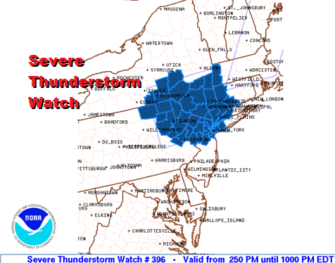
For the second straight evening we are dealing with a severe thunderstorm watch from Northeast Pennsylvania to Southern New England. There are actually 2 watches with the second extending from Connecticut to Maine that expires at 8pm.

At least so far the extent of the severe weather is not anywhere close to what we had last night which was a very robust outbreak indeed. Daytime heating today was a bit less than yesterday and that may have made a difference as did some early cloud cover. None the less there are some thunderstorms running around and there is the risk that one or two of them could be severe.
SATELLITE

REGIONAL RADAR

Regional radar is showing a couple of short lines of thunderstorms moving through the Hudson Valley with some other cells in parts of Northern New Jersey and Northeast Pennsylvania. Storms are tailing off today as you go south until you get into Virginia where activity picks up again. Once we get past sunset these storms should disappear to the north but the storms to the south in Virginia and North Carolina could hang around for awhile.
LOCAL RADAR NEW YORK CITY

LOCAL RADAR PHILADELPHIA


Some of what is down south could push northward into Delaware and New Jersey during the hours before daybreak before they push away to the east. A weather front will ease offshore and Friday looks like we start with clouds and then perhaps see some developing sunshine later in the day with highs in the 80s.
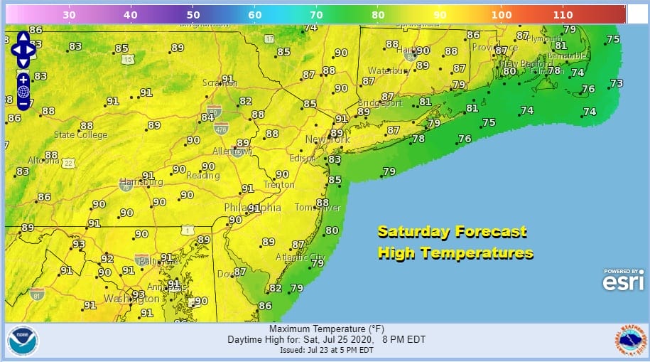
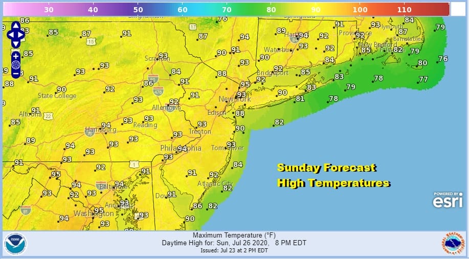
The weekend is looking good but it is also looking hot with sunshine both Saturday and Sunday. Saturday;s highs will be in the upper 80s to lower 90s. Sunday’s highs will reach 90 to 95. Humidity levels will be moderate on Saturday but high on Sunday. No thunderstorms are forecast unless a stray pop up shows up.
Next week the trough comes back to the East which means we will see some changes in the overall scheme of things. The week starts off hot but temperatures should ease and there could be some shots for rain or thunderstorms later next week.
BE SURE TO DOWNLOAD THE FREE METEOROLOGIST JOE CIOFFI WEATHER APP &
ANGRY BEN’S FREE WEATHER APP “THE ANGRY WEATHERMAN!
MANY THANKS TO TROPICAL TIDBITS FOR THE USE OF MAPS
Please note that with regards to any severe weather, tropical storms, or hurricanes, should a storm be threatening, please consult your local National Weather Service office or your local government officials about what action you should be taking to protect life and property.


