
Rain Slides Offshore Hot Weekend Ahead
Yesterday’s cold front got hung up offshore and that has kept much of our area in clouds today. This should eventually slide out to the south and east and weather conditions should start to improve from west to east later this afternoon and tonight. At least the clouds have kept temperatures in check to day and that is a good thing. No 90 degree readings today and where clouds are keeping temperatures in the 70s, it is a nice welcomed change from last week’s heat.

REGIONAL RADAR

Radar shows an area of heavy rain and thunderstorms grazing the coast and sliding offshore slowly but surely. There are other showers scattered back in Central Pennsylvania with little if anything going on to the north. Radars will go quiet this weekend.
LOCAL RADAR NEW YORK CITY

LOCAL RADAR PHILADELPHIA


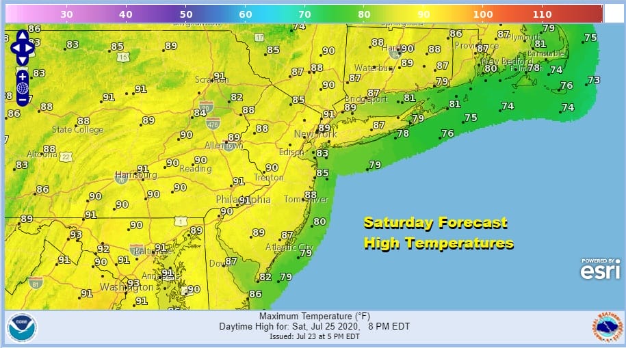
We will partially clear tonight with most lows in the mid 60s to lower 70s. Then we start the weekend off with sunshine for Saturday. It will be a very warm to hot day and a somewhat humid day but I don’t think it will be oppressive. Highs will reach the upper 80s to around or just over 90 in some places.
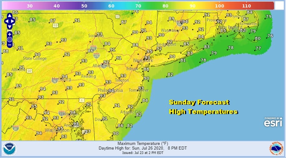
Sunday we take things up a notch or two with sunshine hot and humid conditions. Most highs will be in the low to mid 90s. There will be little to no thunderstorm activity over the weekend. It makes for a simple forecast for the last weekend of July.
Looking ahead to next week Monday and Tuesday look to be hot and humid and we do have a cold front that will be arriving late Tuesday. Perhaps we could get a shower or thunderstorm out that when it goes by.

Once it goes by we should get a little bit of humidity relief for a day or two late next week. For now it seems that shower and thunderstorm activity will be confined to the frontal passage and not much happens late next week unless the front gets hung up for some reason. Temperatures will be a bit lower starting Wednesday with highs mostly in the 80s and nights in the 60s to near 70.
BE SURE TO DOWNLOAD THE FREE METEOROLOGIST JOE CIOFFI WEATHER APP &
ANGRY BEN’S FREE WEATHER APP “THE ANGRY WEATHERMAN!
MANY THANKS TO TROPICAL TIDBITS FOR THE USE OF MAPS
Please note that with regards to any severe weather, tropical storms, or hurricanes, should a storm be threatening, please consult your local National Weather Service office or your local government officials about what action you should be taking to protect life and property.


