
Saint Patrick’s Day #Beastfromtheeast #Foureaster Outlook
Saint Patrick’s Day #Beastfromtheeast #Foureaster Outlook
The weekend is upon us and we have a nice weekend although it will be on the chilly side. This evening we are seeing the last of the clouds and scattered snow showers that were around today and skies will clear out tonight. It will be a cold night with lows in the 20s but cold spots inland could see teens. Winds have been strong and gusty all day and that will continue into at least part of tonight.
SATURDAY MORNING FORECAST LOW TEMPERATURES

US SATELLITE

The satellite picture shows a lot of clouds to the west as low pressure comes out of the Central Plains. That system will move southeast and weaken rapidly overnight and on Saturday. Some high clouds could reach Southern New Jersey and Southeastern Pennsylvania later Saturday but it should be partly to mostly sunny for much of the area. Full sun and less wind should take temperatures up through the 40s.
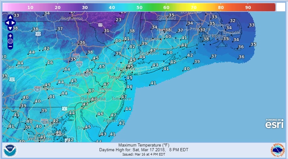
SATURDAY FORECAST HIGH TEMPERATURES
REGIONAL RADAR

There are no issues for Sunday with sunshine and chilly highs in the low to mid 40s. Monday looks good too with sunshine and highs in the low to mid 40s.
#Beastfromtheeast2 #Foureaster Outlook
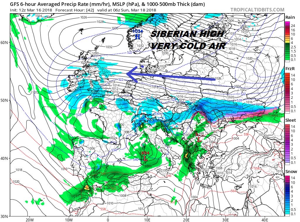
The atmosphere remains in a high state of volatility across the North Atlantic and it is impacting the weather on both sides of the globe. To the east in Europe and Britain we have what is being called #beastfromtheeast2 which is another Siberian air mass that has swept westward. Britain & Ireland could see some snow this weekend but it should not be like the blizzard of a few weeks ago.
#BEASTFROMTHEEAST2 COLD AIR ACROSS EUROPE THIS WEEKEND
Meanwhile back home after the weekend attention shifts to the next storm or as we are calling it, a possible #foureaster given this could be the forth coastal storm in the last 2 1/2 weeks. There are too many moving parts with this developing scenario to come to any kind of conclusion about this.

You can see the puzzle pieces on the map above. I think the biggest question is regarding that low you see called the 50/50 low. We call it that because it is located near 50 degrees north latitude & 50 degrees west longitude or close to New Foundland. That storm serves two important functions. It keeps cold air in the east and it acts as a block forcing storms to track to our south. The question is whether it gets out of the way just enough to allow any southern systems to turn up the east coast. With so much energy running around it is impossible to come to a conclusion this early in the game. Weather models are having an equally tough time with this. For now we continue to watch. You may see or hear things about this storm. There is no certainty with this yet and I doubt we will have any better idea on this until Sunday at the earliest and even then it will be a rough guess. All we can say is right now nothing happens through Monday. IF there is a threat form this it would be Tuesday and/or Wednesday. In the meantime Happy Saint Patrick’s Day and enjoy the weekend.
 GET JOE A CIGAR IF YOU LIKE

FiOS1 News Weather Forecast For Long Island
FiOS1 News Weather Forecast For New Jersey
FiOS1 News Weather Forecast For Hudson Valley


