
We are waiting for an upper high that has been sitting along the east coast for the last 2 days to finally break down and allow moisture now moving across the entire Mississippi Valley to make some genuine eastward progress. The satellite loop shows it pretty clear that the storm coming out of Western Kansas is pulling a ton of moisture northward from Louisiana all the way north to the Canadian border.


Radar shows what happens when showers hit the upper high and dry air. You can see them on the radar in parts of Western parts of West Virginia and Virginia but the echos just fall apart and dry out.
Once the upper high breaks down we will see that moisture start to move in here. Skies tonight will be clear and it will be cold with many cold spots down in the upper 20s to lower 30s while warmer urban areas will be in the upper 30s to around 40. Some early sunshine is possible on Wednesday but clouds will increase rather quickly as we go through the afternoon and evening and there could even be some spotty light rain or drizzle moving in during the evening hours.
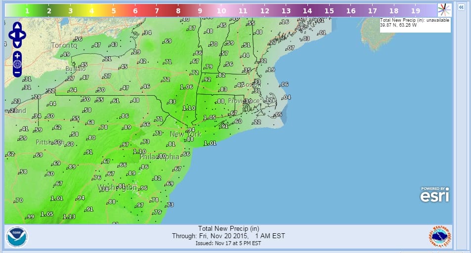
Thursday is the day we should see a wall of rain move through beginning in Eastern Pennsylvania and Western New Jersey during the morning and arriving in eastern areas of Connecticut and Long Island during the afternoon. Forecast rainfall amounts have increased a bit. I hoping for a general 1 to 2 inch rainfall before this is all done later Thursday night.
Thursday’s highs will be in the low to mid 60s. Also look for possible thunderstorms with the system later Thursday afternoon and evening. Friday will be dry with highs in the 50s. Then much colder over the weekend with some showers Saturday night that could end as snow showers in some areas Sunday morning.
JOESTRADAMUS LONG RANGE FORECAST FOR THANKSGIVING WEEK
NAM WEATHER MODEL FOR THURSDAY’S RAIN
FIOS1 NEWS FORECAST FOR THE LOWER HUDSON VALLEY NY