
Rain Tonight On And Off Thursday Drying Out
Colder Weather Weekend Next Week

Rain Tonight On And Off Thursday Drying Out
Colder Weather Weekend Next Week

Weather conditions are going to deteriorate as the day wears on. Skies were clear overnight which led to some chilly temperatures this morning. Clouds are moving northeastward on satellite loops so look for increasing cloudiness. We also will have an ocean wind and that will keep temperatures mostly in the 40s to around 50 or so this afternoon and evening. For some areas the highs for the day probably won’t occur until tonight as temperatures hold steady or even rise a bit thanks to an approaching slow moving warm front.
SATELLITE

WEATHER RADAR

As far as rain is concerned, we won’t see much of anything during the daytime. The rain on the radar is mostly to the west and northwest and moving north northeastward. Late this afternoon as rain develops to the south we will see some develop in Southern Pennsylvania, Southern New Jersey and points south and that will spread northward quickly this evening. Rain overnight will last into Thursday morning.

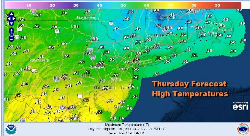
The warm front to the south will stall out nearby Thursday and that will keep us in clouds. The cold front will also stall out nearby as it waits for another wave to develop. This will leave us in a situation where any rain will be more on and off. The GFS and other models show a final surge of rain coming Thursday afternoon and evening. Temperatures will be in a wide range from 50s NYC north and east to 60s Philadelphia south and southwest.
Once the rain exits Thursday evening with the final wave, weather conditions should improve overnight with partial clearing of skies. Friday morning lows will be in the 40s. Rainfall amounts will be on the order of 3/4 inch to an inch and a half total from west to east.

A new pattern is emerging for the intermediate term that will favor colder than average temperatures for the last days of March and the start of April. A blocking pattern which was absent all winter long in the North Altantic is setting up and that will favor a cold flow from Eastern Canada into the Northeast. The decline in temperatures will be in stair step fashion. Friday look for a mix of sun and clouds with highs in the 50s. Saturday will be a breezy to windy day as an upper trough moves through. We could see some rain showers scattered around and maybe snow showers well inland from this during the afternoon especially inland. Highs Saturday will be in the low to mid 50s. Sunday will be breezy and colder with some sunshine. Highs will be in the 40s. Monday morning will be quite cold with lows in the 20s and well inland we will see lows in the upper teens. Monday looks sunny but cold with highs just in the upper 30s and lower 40s and that is almost 15 degrees below average. The blocky pattern continues next week keeping the area in below average temperatures all week long. For now it looks dry until the middle of next week with the next weather system heads our way from the west.
BE SURE TO DOWNLOAD THE FREE METEOROLOGIST JOE CIOFFI WEATHER APP &
ANGRY BEN’S FREE WEATHER APP “THE ANGRY WEATHERMAN!
MANY THANKS TO TROPICAL TIDBITS & F5 WEATHER FOR THE USE OF MAPS
Please note that with regards to any severe weather, tropical storms, or hurricanes, should a storm be threatening, please consult your local National Weather Service office or your local government officials about what action you should be taking to protect life and property.


