One More Nice Day Before Onshore Flow And Rain Take Over
Chilly Weekend Ahead

One More Nice Day Before Onshore Flow And Rain Take Over
Chilly Weekend Ahead

All of the action today is to the west and southwest as a strong storm heads out of the Southern Plains and moves up the Middle Mississippi Valley. Meanwhile high pressure to the northeast of the Great Lakes is necking down into the Northeast and Northern Mid Atlantic. This will mean one more nice day of sunshine. We are noticing some high clouds on the satellite but that is just the occasional minor issue. Temperatures today will top out in the upper 50s to around 60 inland. It will be a little cooler along the shore with local sea breezes developing. The radars are nice and quiet right now and should remain so into early Wednesday.
SATELLITE

WEATHER RADAR

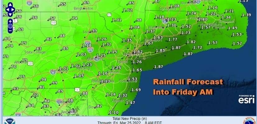
Weather conditions will deteriorate Wednesday as low pressure tracks well to our west but a warm front will set up across Southern Virginia eastward. This is going to put us in an onshore flow. Wednesday will be a raw day with cloudy skies and rain developing from south to north as the day wears on. Most highs will be in the 40s to at best upper 40s and lower 50s.

We will see on and off rain through Thursday as we have to wait for the upper air trough to move eastward and push this system out offshore. That should begin to happen late Thursday into Thursday night. We will see temperatures nudge higher Thursday as the onshore flow begins to relax a bit and a cold front moves through. One last wave on the front will allow for dry air to come in Friday. Rainfall amounts will be an inch or more spread out over 2 days. Temperatures Thursday will be in the 50s to near 60 in most places except right near the coast.

Friday should bring some improvement though slowly. Clouds will decrease as the day wears on but we are headed into a chilly weather pattern this weekend. Blocking is developing in the North Atlantic which will mean below average temperatures for the Northeast this weekend and into next week. It does appear that for much of our area it will be dry though cold unstable air aloft will likely mean some clouds from time to time this weekend. Friday’s highs will be in the 60s but we will be cooler over the weekend. Saturday highs will be in the low to mid 50s. Sunday highs will be just in the 40s.
BE SURE TO DOWNLOAD THE FREE METEOROLOGIST JOE CIOFFI WEATHER APP &
ANGRY BEN’S FREE WEATHER APP “THE ANGRY WEATHERMAN!
MANY THANKS TO TROPICAL TIDBITS & F5 WEATHER FOR THE USE OF MAPS
Please note that with regards to any severe weather, tropical storms, or hurricanes, should a storm be threatening, please consult your local National Weather Service office or your local government officials about what action you should be taking to protect life and property.


