Rain South Jersey Tonight Columbus Day Sunshine
Major Storm Develops Northeast Wednesday
Much of Sunday was fine however clouds have rolled in and we are seeing a bit of rain showing up in South Jersey this evening. This is due to a weak stalled frontal boundary that lies just offshore and extends southward into Virginia and North Carolina. A weak wave on this front is taking an area of unimpressive rain northeastward. The bulk of this passes south and east of our area (Eastern Pennsylvania to Southern New England) though some areas from South Jersey southward will see a little bit of rain from this. Otherwise look for clouds around tonight. A weak front from the west will push everything out tonight and skies will partially clear by morning with lows in the 50s.
SATELLITE

REGIONAL RADAR

Regional radar is showing an area of rain from South Jersey into North Carolina. The rain is patchy and generally sliding to the east northeast. Some of that rain is showing up on the local radars below but for the vast majority of both radars there are no rain issues this evening or overnight.
LOCAL RADAR NEW YORK CITY

LOCAL RADAR PHILADELPHIA


Monday is Columbus Day and we can look forward to a very nice day of sunshine and highs in the upper 60s to around or just over 70. High pressure is building in and cooler air moves in Monday night with most lows in the 40s. Tuesday looks good with sunshine most of the day though some high clouds will arrive later in the day. Highs will be in the cooler low to mid 60s.
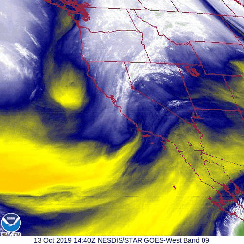
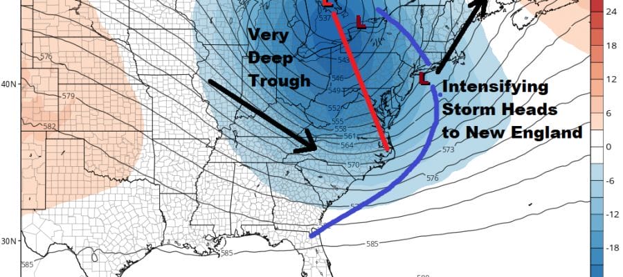
Looking at the water vapor loop at the middle levels of the atmosphere we are seeing the next strong trough moving into the Northwestern US. This trough is going to become a powerhouse when it reaches the Eastern US midweek. A strong upper low forms over the Great Lakes with a deep trough extending southeast to the Carolinas.
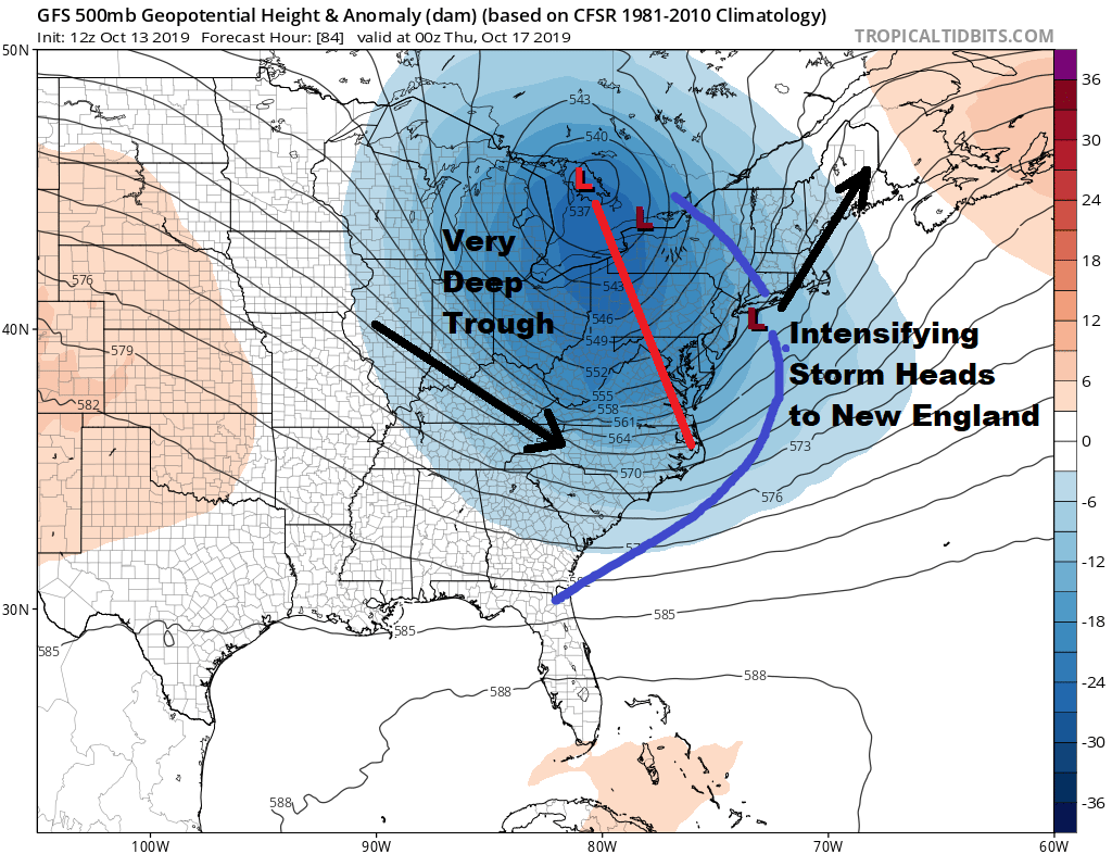
This brings a low across the lakes toward Western NY. A southern feature will evolve and then turn northeast in tandem with the Great Lakes low and we will wind up with a major storm by the time it reaches the Gulf of Maine Thursday morning.

Wednesday will bring a fast moving area of heavy rain northeastward and this will be the first area wide rainfall we have seen here since back last spring. There might be a thunderstorm or two in the mix here and rainfall amounts could be at least an inch area wide and it might be on the order of 1 to 2 inches for most areas.
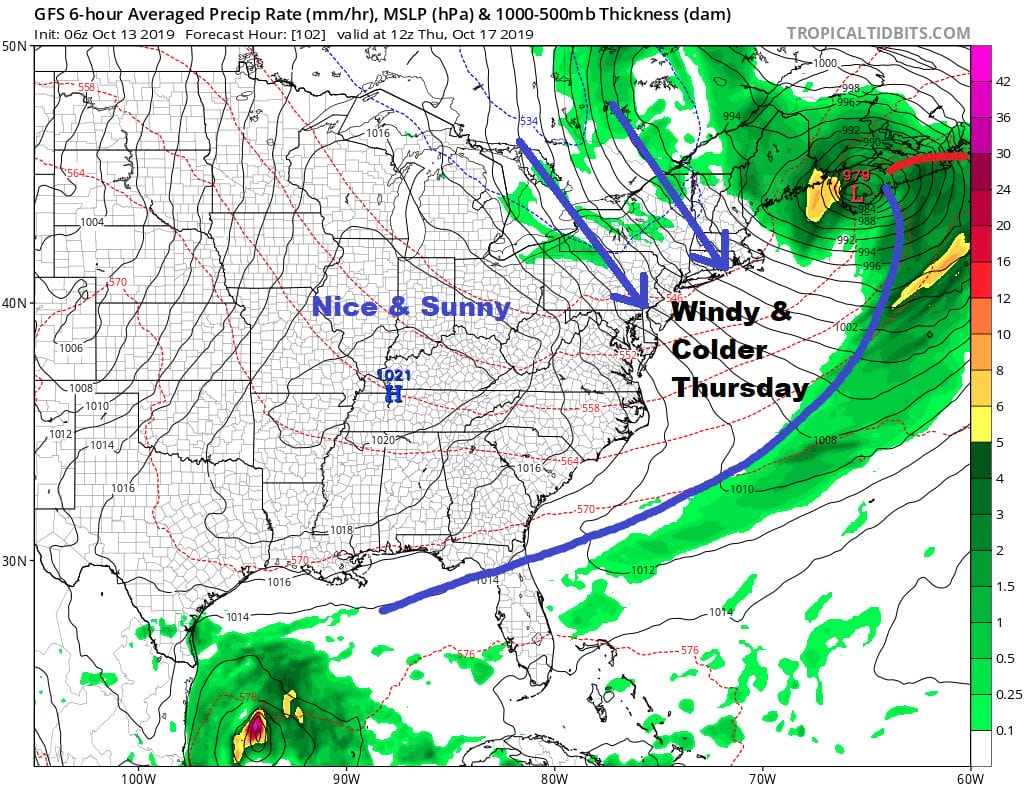
Behind this storm on Thursday it will be a windy chilly day. Expect winds to gust to 30 to 40 mph during Thursday with clouds and some sunshine. Highs will only be in the 50s. HIgh pressure builds in Friday with less wind and sunshine. Highs will be in the upper 50s and lower 60s. We seem to be in line for a warm up next weekend before the next trough and cold front move through the Eastern US a week from Monday. The long range pattern remains progressive which means everything keeps moving along from west to east with clouds fronts moving through from time to time and no prolonged warm ups or cool downs as systems come in and go out with regularity.
MANY THANKS TO TROPICAL TIDBITS FOR THE USE OF MAPS
Please note that with regards to any severe weather, tropical storms, or hurricanes, should a storm be threatening, please consult your local National Weather Service office or your local government officials about what action you should be taking to protect life and property.


