Columbus Day Sunshine Midweek Rain Late Week Wind Chill
One storm system dominates the weather scene this week in the Eastern US and that will come Wednesday with a major storm set to develop in the Northeast. It is going to be a quick round of rain and eventually wind that moves through that puts down an inch or so of rain followed but strong gusty winds and an autumn chill for Thursday and Friday. However getting there we have two nice days ahead with sunshine on this Monday Columbus Day which is a holiday for most. Highs today will reach the upper 60s to lower 70s.
SATELLITE

REGIONAL RADAR

Clouds that are on the satellite picture this morning are part of the old frontal boundary that is offshore and pushing eastward taking whatever showers that are on the regional and local radar views off the screen and out of range. To the west we have dry air that will be with us into Tuesday.
LOCAL RADAR NEW YORK CITY

LOCAL RADAR PHILADELPHIA


Tonight will be clear and chilly with most lows in the 40s except for near 50 in warmer urban areas and a few 30s in cold spots. Tuesday remains a nice day with sunshine most of the day and highs will be in the cooler low to mid 60s.

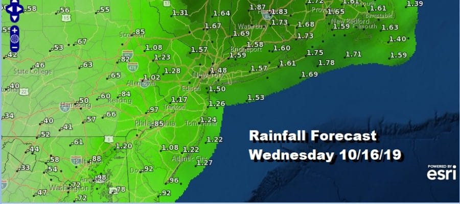
This morning’s water vapor loop shows dry air moving into the East as an upper air low swings across the Great Lakes and Eastern Canada. To the west we can see the bright white images that are moving into Northwest US which is our next weather system for Wednesday. Moisture is also shooting across Mexico into Texas which is setting up a southern feeder into this system. The result will be a developing storm with a cold front heading for the East Wednesday with rain and some gusty winds and perhaps even a thunderstorm or two. This is going to be a fast 6 to 8 hour event of rain that should produce about an inch or so in most places with lesser amounts to the southwest of NYC and higher amounts to the northeast in Southern New England.

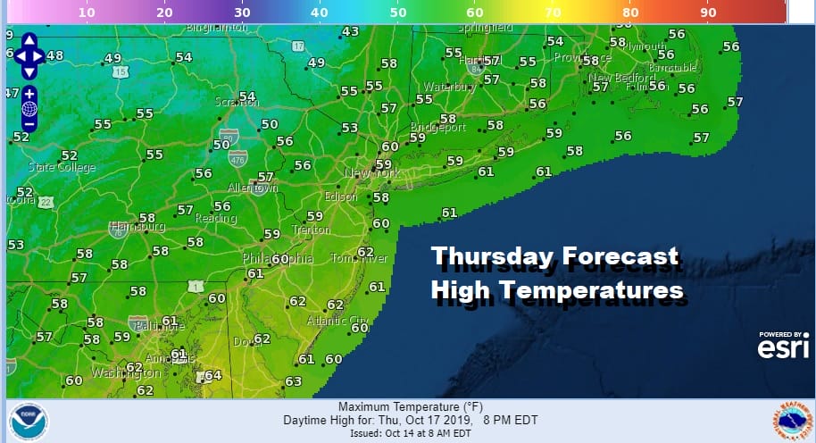
Once this low moves away to the northeast into New England it will strengthen into a powerhouse and the result Thursday will be strong gusty winds. We are anticipating winds of 20 to 30 mph with gusts over 40 mph in some places along with some sun and clouds and an autumn chill in the air. Highs Thursday will be just in the 50s.
Friday starts breezy but winds will finally die off with some sunshine to finish the week. Highs Friday will be in the 50s. We are going to see a dry weekend as temperatures rise back into the 60s Saturday and perhaps into the 70s in some places on Sunday. Showers might start appearing next Monday as the next frontal system begins its inital approach.
MANY THANKS TO TROPICAL TIDBITS FOR THE USE OF MAPS
Please note that with regards to any severe weather, tropical storms, or hurricanes, should a storm be threatening, please consult your local National Weather Service office or your local government officials about what action you should be taking to protect life and property.


