
Nice Weather Tuesday Major Storm Develops Wednesday Very Windy Chilly Thursday Friday
For the most part this Columbus Day was a fairly good day after we chewed through some leftover clouds this morning. The afternoon for most was mostly sunny. We topped out in the upper 60s and lower 70s. It was a nice finish to the holiday weekend. Now we move ahead to a night with mainly clear skies with most lows in the 40s to around 50 as cooler air arrives into the Northeast and Northern Mid Atlantic States.
SATELLITE

REGIONAL RADAR

Regional and local radars are quiet and will remain so through Tuesday which will be nice and sunny most of the day from Virginia to New England. Some high clouds could approach late in the afternoon or evening but there are no issues. It will be rather cool on Tuesday with highs just in the low to mid 60s.

Get ready for a solid shot of rain for Wednesday especially in the afternoon and evening from Eastern Pennsylvania to Southern New England. It arrives during the morning reaching NYC around noon and Southern New England shortly after that. The rains will end late in the afternoon south and west of Philadelphia and late evening north and east of NYC. In that 6 to 8 hour period there could be anywhere from an inch to as much as 2 inches of rain. Temperatures Wednesday will be in the 60s.

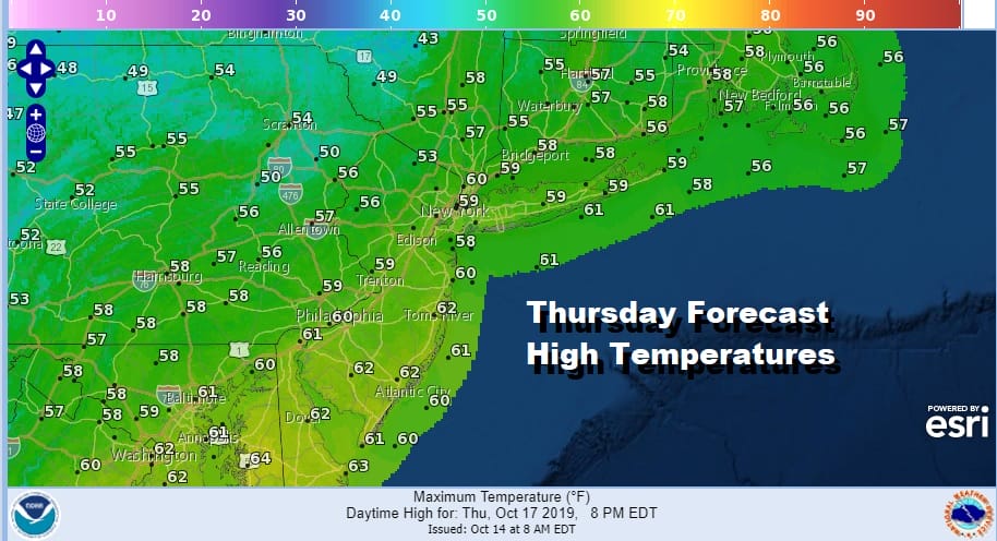
Low pressure moving across the Great Lakes will transfer its energy to a coastal low and the loop above it the nam model intensifying that low rather rapidly late Wednesday into Thursday morning. Behind the storm to the southwest of the low center the pressure gradient on Thursday will be very tight. While we will go to a mix of sun and clouds Thursday winds will be strong and gusty to 30 to 40 mph at times especially along the coast. Temperatures Thursday won’t get out of the 50s.
We don’t see much change for Friday which will be a sunny but chilly day with highs in the 50s to near 60 with diminishing winds. We still believe the weekend will warm a bit with 60s on Saturday and upper 60s to lower 70s on Sunday with some sunshine both days. Showers could return Monday into Tuesday as the next strong cold front approaches in a very active busy pattern ahead.
MANY THANKS TO TROPICAL TIDBITS FOR THE USE OF MAPS
Please note that with regards to any severe weather, tropical storms, or hurricanes, should a storm be threatening, please consult your local National Weather Service office or your local government officials about what action you should be taking to protect life and property.


