Rain Shifts East Today Leftover Showers
Slow Improvement Weekend Heat Back Tuesday

Weather in 5/Joe & Joe Weather Show Latest Podcast
Rain Shifts East Today Leftover Showers
Slow Improvement Weekend Heat Back Tuesday
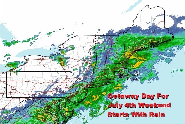
Getaway day for the 4th of July weekend gets off to a rainy start as we have a very slow moving frontal boundary right over us. The first wave is moving to the northeast and that should take the steady rain slowly eastward and offshore today but a second wave develops to the south. This wave will push the frontal boundary a little further to the east. Rain will taper off to on and off showers as the day rolls on. Temperatures today will be in the 70s and humidity levels will still be high until the second wave goes by tonight.
SATELLITE

Rain continues to be visible on the radars but the western edge of the steady rain is making slow progress eastward. The regional radar shows the rain area extends south into Virginia and North Carolina where heavier downpours and thunderstorms will continue today. Here that back edge will remain close by into this evening so watch for occasional showers this afternoon into this evening.
WEATHER RADAR


The second wave pulls away to the northeast tonight and drier air will move southward. However on Saturday we still have an issue with an upper trough moving across the Northeast. This will likely keep us in clouds on Saturday along with the risk for scattered showers. Temperatures Saturday will be in the 60s across Southern New England and Long Island while areas to the south (Southern New Jersey, Southern Pennsylvania southward) could see some breaks of sun and temperatures there will top into the 70s.

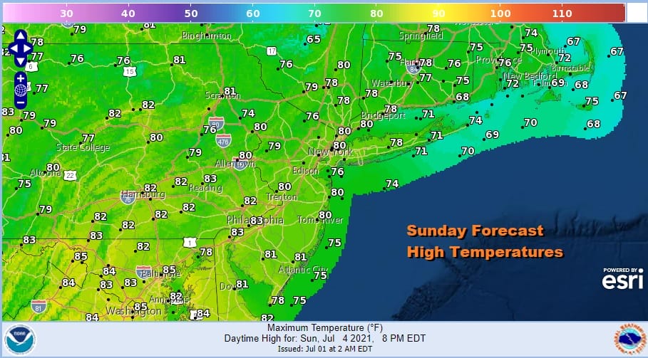
The upper trough finally moves through to the east Saturday night and we should clear by Sunday morning. Sunday we will see partly sunny skies as there will be some patchy clouds around. It will be on the pleasant side with dew points in the 50s and temperatures rebounding to the 70s to near 80 degrees in warm spots.
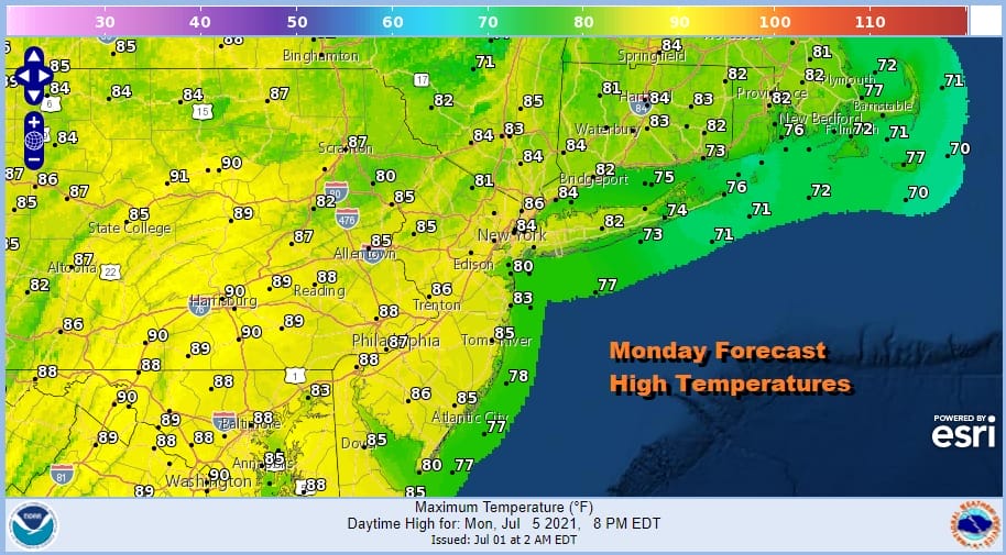
We see no issues Sunday night as skies should be clear with lows in the 60s in warmer urban and coastal areas and 50s inland. Monday we will have sunshine to finish off the three day holiday weekend. Highs will be in the mid to upper 80s on average.
Heat and humidity return on Tuesday with sunshine taking highs back to the low and middle 90s in most places. Dew points will be pushing 70 again making for a very uncomfortable day. This could trigger some thunderstorms late in the day ahead of an upper trough moving through the Northeast Tuesday evening. All in all it is not a perfect summer weekend for the 4th of July as Saturday will be subpar but Sunday and Monday look good and fireworks will go off without a weather hitch.
BE SURE TO DOWNLOAD THE FREE METEOROLOGIST JOE CIOFFI WEATHER APP &
ANGRY BEN’S FREE WEATHER APP “THE ANGRY WEATHERMAN!

MANY THANKS TO TROPICAL TIDBITS & F5 WEATHER FOR THE USE OF MAPS
Please note that with regards to any severe weather, tropical storms, or hurricanes, should a storm be threatening, please consult your local National Weather Service office or your local government officials about what action you should be taking to protect life and property.


