Rain Round 1 Shifts North Thunderstorms Evening Tuesday
Rain Round 1 Shifts North Thunderstorms Evening Tuesday
FLASH FLOOD WARNING MONMOUTH OCEAN COUNTIES UNTIL 3:30PM

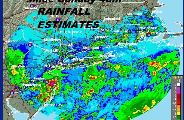
Rainfall estimates have been extreme today espeically in Coastal New Jersey where 3.5-5″ inches has fallen based on doppler radar estimates. The other area that was hit hard was in Eastern & Southeastern Pennsylvania where widespread 3 to 5 inches of rain fell. River flooding is extensive and flood warnings continue as rivers and streams continue to rise.

Radars show the rain from this morning is shifting northward into Northeast Pennsylvania, the Hudson Valley & Connecticut. Heavy rains are over the Eastern half of Long Island. Areas to the south in Southeastern Pennsylvania and Southern New Jersey are getting a bit of a break this afternoon but now the next concern will be thunderstorms firing up in a few places and some of these thunderstorms could be strong or even isolated severe thunderstorms are not impossible. Flash Flood Watches continue into this evening due to threat of additional downpours. Temperatures have gone anywhere today holding mostly in the 70s. Where clouds break up this afternoon some self destructive sunshine will develop which brings more clouds which brings downpour development.
EASTERN SATELLITE

REGIONAL RADAR

LOCAL RADAR NEW YORK CITY

LOCAL RADAR PHILADELPHIA


It appears that we have one more day of downpour and thunderstorm risk on Tuesday as the upper air storm to the west begins to move eastward and weaken. This will likely trigger off some additional downpours and thunderstorms during Tuesday into Tuesday evening with temperatures into the 80s. Then finally some improvement arrives Wednesday and Thursday with sunshine. It will be hot though since the air to the west is not a cool shot from Canada but warm air from the Plains. Highs could reach 90 or better in some places. However we think that while Wednesday and Thursday will be hot they should be thunderstorm free.
MANY THANKS TO TROPICAL TIDBITS FOR THE USE OF MAPS
Please note that with regards to any tropical storms or hurricanes, should a storm be threatening, please consult your local National Weather Service office or your local government officials about what action you should be taking to protect life and property.
LATEST JOESTRADAMUS ON THE LONG RANGE


