DOWNLOAD MY NEW FREE JOESTRADAMUS WEATHER APP FOR ANDROID

SUBSCRIBE TO PATREON FOR A WEATHER EXPERIENCE FREE OF ADS, EXCLUSIVE VIDEOS FOR MEMBERS ONLY AND MUCH MORE…STARTS AT $2 A MONTH..MESSAGE ME AT ANY TIME

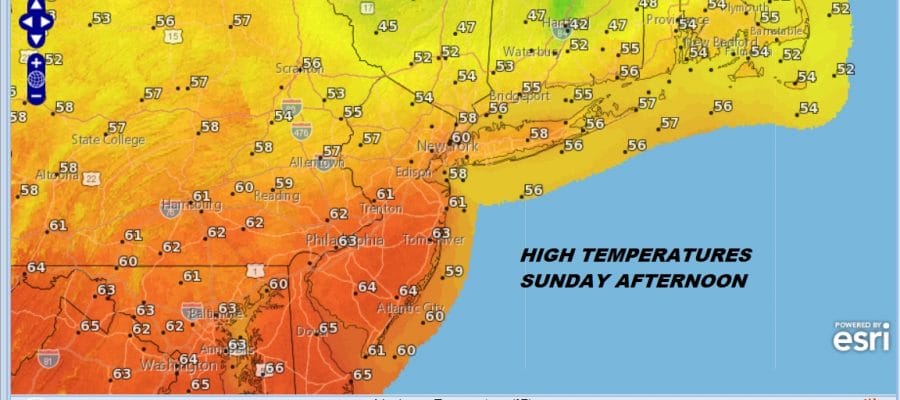
Rain Overnight Warmer Sunday Afternoon Colder Week Ahead
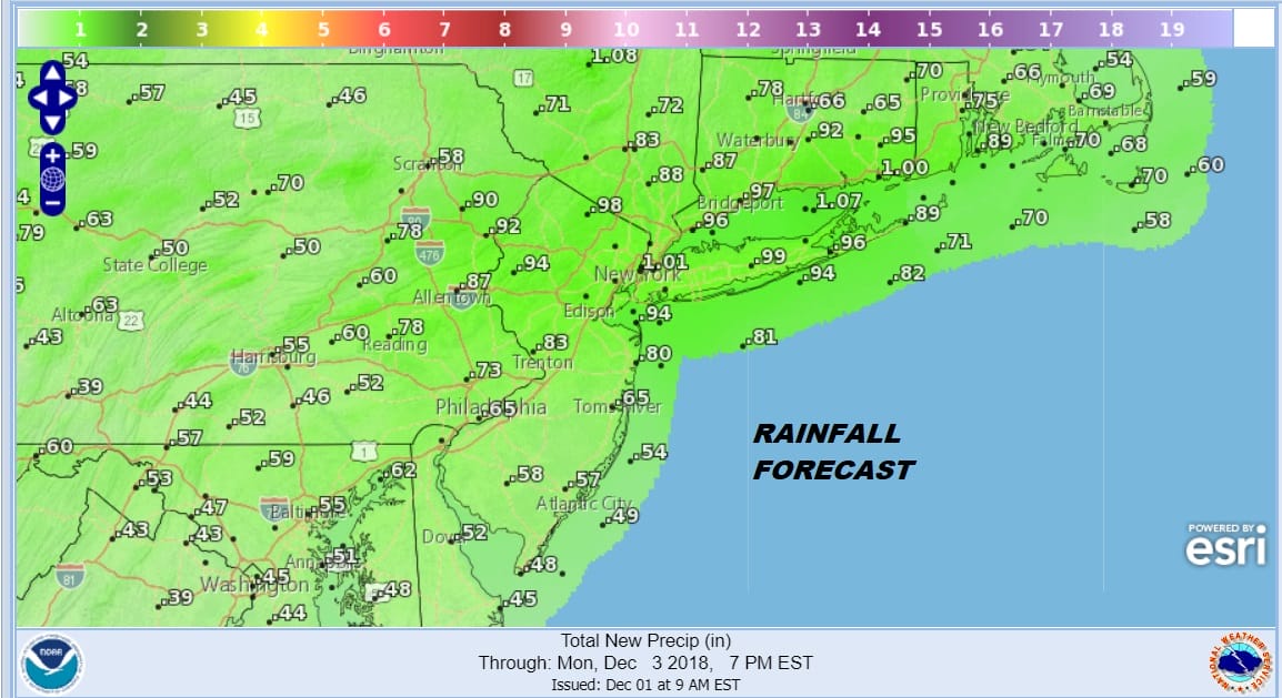
The best part of the weekend in terms of the amount of sunshine is this morning. We cleared out overnight thanks to dry air and high pressure that built in overnight in New England. Sunshine should last into midday before clouds sweep in from the southwest this afternoon. Temperatures will be on the chilly side today with highs just into the 40s. Then low pressure from the Midwest begins to exert its influence as a front sweeps northward. Rain develops late this afternoon across New Jersey and spreads into NYC, Long Island, the Hudson Valley & Southern New England tonight. There will be some heavier downpours into daybreak Sunday.
EASTERN SATELLITE

REGIONAL RADAR

Regional radar shows the easternmost edge of the rain sweeping in from the southwest but it has a ways to go before it gets here. Local radars are quiet for the time being. Rainfall amounts should be on the order of 3/4 inch to 1 inch with a few places finishing a bit higher.
Sunday’s dilemma is whether the warm front gets through or not. Rain should taper off to passing showers into midday and then greater improvement in the afternoon. New Jersey highs should reach into the 60s However north and east of NYC temperatures will struggle in the 50s and some areas of the Hudson Valley will not get out of the 40s.

THE WEEK AHEAD
Right now the work week ahead looks relatively uneventful. There was concern early this week for the Tuesday/Wednesday time frame but it seems that low pressure develops well offshore with no consequences here. A couple of cold fronts move through with each one followed by a progressively colder air mass but with no real weather issues. Highs will be in the 50s Monday, 40s Tuesday and 30s for Wednesday through Friday. Each day should feature some sunshine. Even though it will be turning colder at least we will have 5 days with no rain or snow. Weather models continue to zero in on possibilities for snow next weekend but we are still too far out for any meaningful speculation on this.
MANY THANKS TO TROPICAL TIDBITS FOR THE USE OF MAPS
Please note that with regards to any tropical storms or hurricanes, should a storm be threatening, please consult your local National Weather Service office or your local government officials about what action you should be taking to protect life and property.

