Rain Overnight Heavy Downpours Near Low Center
Rain Overnight Heavy Downpours Near Low Center
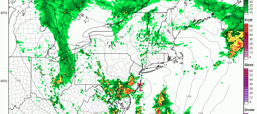
The first round of rain has moved north of the coast and now we wait for the upper air storm system now moving across Ohio to swing east and move overhead tonight. This is going to generate development of a coastal low and a core of downpours and possibly a thunderstorm or two in the mix tonight. Look for rain to develop again later this evening in Southern New Jersey & Southeastern Pennsylvania and then swing northward to Long Island, Connecticut, Northern New Jersey and the Hudson Valley before midnight.
RAIN OVERNIGHT HEAVY DOWNPOURS HRRR MODEL 8PM THURSDAY-2AM FRIDAY CLICK TO ANIMATE

The HRRR model is not the best model out there but none of the others have been much better so we are going with this idea. Rainfall amounts overnight could reach an inch or so in some places. Once this low moves northeastward weather conditions should improve somewhat on Friday.
SATELLITE LOOP

REGIONAL RADAR

LOCAL RADAR NEW YORK CITY

LOCAL RADAR PHILADELPHIA


Friday we will see leftover clouds and some passing showers are possible. The lack of an onshore flow should allow temperatures to get back into the 70s.
For the weekend I’m going to stick with my original idea with Saturday being the best of the three days. Sun mixed with clouds on Saturday is the forecast though a couple of models are suggesting a chance for late showers as a system goes by to our south. Right now I’m not buying it. Sunday we will see sun and arriving clouds and maybe some late showers and the same for Monday. Temperatures over the weekend should reach the 70s except Sunday there could be an onshore flow that keeps areas closer to the coast in the 60s to near 70.
 GET JOE A CIGAR IF YOU LIKE

LANDSCAPE COMPANIES FOR YOUR NEEDS
LONG ISLAND ROCKLAND COUNTY Connecticut

![]()

ROCKLAND COUNTY TRI STATE SNOW REMOVAL JOHNSTOWN PA


FiOS1 News Weather Forecast For Long Island
FiOS1 News Weather Forecast For New Jersey
FiOS1 News Weather Forecast For Hudson Valley
NATIONAL WEATHER SERVICE SNOW FORECASTS
LATEST JOESTRADAMUS ON THE LONG RANGE
Weather App

Don’t be without Meteorologist Joe Cioffi’s weather app. It is really a meteorologist app because you get my forecasts and my analysis and not some automated computer generated forecast based on the GFS model. This is why your app forecast changes every 6 hours. It is model driven with no human input at all. It gives you an icon, a temperature and no insight whatsoever.
It is a complete weather app to suit your forecast needs. All the weather information you need is right on your phone. Android or I-phone, use it to keep track of all the latest weather information and forecasts. This weather app is also free of advertising so you don’t have to worry about security issues with your device. An accurate forecast and no worries that your device is being compromised.
Use it in conjunction with my website and my facebook and twitter and you have complete weather coverage of all the latest weather and the long range outlook. The website has been redone and upgraded. Its easy to use and everything is archived so you can see how well Joe does or doesn’t do when it comes to forecasts and outlooks.
Just click on the google play button or the apple store button on the sidebar for my app which is on My Weather Concierge. Download the app for free. Subscribe to my forecasts on an ad free environment for just 99 cents a month.
Get my forecasts in the palm of your hand for less than the cost of a cup of Joe!


