Memorial Day Weekend Outlook Mostly Dry But!
Memorial Day Weekend Outlook Mostly Dry But!
Last night’s producer of heavy down pours is now moving away to the northeast as low pressure strengthens east of Boston this morning. Radars as showing the back edge of the rain this morning in Western New England but this will be pulling away in short order. The strong upper air system will be close by today so look for leftover clouds and perhaps a passing shower or two. With the wind now northwest instead of east, temperatures today will reach into the 70s just about everywhere for highs.
SATELLITE LOOP

REGIONAL RADAR

LOCAL RADAR NEW YORK CITY

LOCAL RADAR PHILADELPHIA


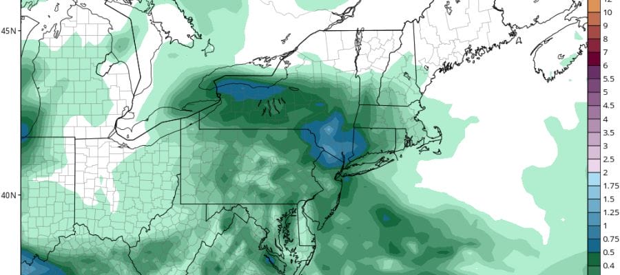
The weekend is going to break down where much of the time it wont’t be raining but it will not be picture perfect. Saturday looked like the best of the three days but it appears that a disturbance will be moving through Saturday night with some showers though not all models have this idea. Some are very weak with this system. Then you have this from the GFS which produces 1/2-3/4 inch of rain later Saturday afternoon into early Sunday morning.
MEMORIAL DAY WEEKEND RAIN FORECAST SATURDAY NIGHT

Sunday dayside looks dry and we could go to a mix of sun and clouds (with a little luck). The next front approaches Monday with maybe a few late showers in some areas but not in others.
The bottom line is that most of the time this weekend it will be dry but it may not exactly be bright and sunny. Temperatures by day should reach the 70s each of the three days. If you are headed for the shore the wind will be onshore from time to time and when it is it will be in the chilly 60s or even at times the 50s.
 GET JOE A CIGAR IF YOU LIKE

LANDSCAPE COMPANIES FOR YOUR NEEDS
LONG ISLAND ROCKLAND COUNTY Connecticut

![]()

ROCKLAND COUNTY TRI STATE SNOW REMOVAL JOHNSTOWN PA


FiOS1 News Weather Forecast For Long Island
FiOS1 News Weather Forecast For New Jersey
FiOS1 News Weather Forecast For Hudson Valley
NATIONAL WEATHER SERVICE SNOW FORECASTS
LATEST JOESTRADAMUS ON THE LONG RANGE
Weather App

Don’t be without Meteorologist Joe Cioffi’s weather app. It is really a meteorologist app because you get my forecasts and my analysis and not some automated computer generated forecast based on the GFS model. This is why your app forecast changes every 6 hours. It is model driven with no human input at all. It gives you an icon, a temperature and no insight whatsoever.
It is a complete weather app to suit your forecast needs. All the weather information you need is right on your phone. Android or I-phone, use it to keep track of all the latest weather information and forecasts. This weather app is also free of advertising so you don’t have to worry about security issues with your device. An accurate forecast and no worries that your device is being compromised.
Use it in conjunction with my website and my facebook and twitter and you have complete weather coverage of all the latest weather and the long range outlook. The website has been redone and upgraded. Its easy to use and everything is archived so you can see how well Joe does or doesn’t do when it comes to forecasts and outlooks.
Just click on the google play button or the apple store button on the sidebar for my app which is on My Weather Concierge. Download the app for free. Subscribe to my forecasts on an ad free environment for just 99 cents a month.
Get my forecasts in the palm of your hand for less than the cost of a cup of Joe!


