
Rain Moving East & Julia To The South
Rain Moving East & Julia To The South
Dry Saturday
Rain Later Sunday Into Monday
This could have been a very good opportunity for a solid soaking rain from the next cold front and whatever would be left of Tropical Storm Julia were there something more substantial with Julia. Im actually keeping my fingers crossed that Julia could fire up again to a tropical storm and somehow get its moisture involved with approaching cold front to the west. That way instead of getting a half inch to an inch and a half of rain, we could wind up with at least double that amount. Looking at the satellite loop this morning you can see the north south front to the west and Julia off the southeast US Coast as tropical depression this morning. The tops from the thunderstorms have been sheared off but there have been some thunderstorm flare ups near the center this morning so we will watch to see if that lasts.


With regards to today there are no weather issues. We will have sunshine and an onshore flow which will hold temperatures in the 70s. Then look for clouds to come in late tonight and Sunday as the front approaches. Rain will move into Eastern Pennsylvania and northern areas of the Hudson Valley by late Sunday morning but it won’t spread to the coast until later Sunday afternoon. Latest models are slower in moving the rain out on Monday so it could be still raining into early afternoon before weather conditions improve.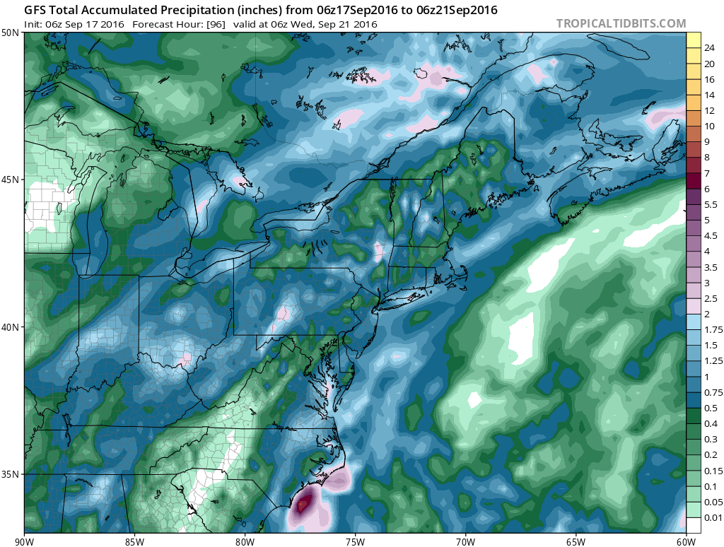
The GFS model is producing 1/2 inch to 1.5 inch amounts over a large area. Most of the weather models are in this range. Hopefully we can at least perform equally to the model forecast and not underperform.
FiOS1 News Weather Forecast For Long Island
FiOS1 News Weather Forecast For New Jersey
FiOS1 News Weather Forecast For Hudson Valley
NATIONAL WEATHER SERVICE SNOW FORECASTS
LATEST JOESTRADAMUS ON THE LONG RANGE
Weather App

Don’t be without Meteorologist Joe Cioffi’s weather app. It is really a meteorologist app because you get my forecasts and my analysis and not some automated computer generated forecast based on the GFS model. This is why your app forecast changes every 6 hours. It is model driven with no human input at all. It gives you an icon, a temperature and no insight whatsoever.
It is a complete weather app to suit your forecast needs. All the weather information you need is right on your phone. Android or I-phone, use it to keep track of all the latest weather information and forecasts. This weather app is also free of advertising so you don’t have to worry about security issues with your device. An accurate forecast and no worries that your device is being compromised.
Use it in conjunction with my website and my facebook and twitter and you have complete weather coverage of all the latest weather and the long range outlook. The website has been redone and upgraded. Its easy to use and everything is archived so you can see how well Joe does or doesn’t do when it comes to forecasts and outlooks.
Just click on the google play button or the apple store button on the sidebar for my app which is on My Weather Concierge. Download the app for free. Subscribe to my forecasts on an ad free environment for just 99 cents a month.
Get my forecasts in the palm of your hand for less than the cost of a cup of Joe!

MENTION JOE CIOFFI AND GET A 5% DISCOUNT


