Rain Into Tonight Mixes With Wet Snow Inland Elevated Areas
Very Cold Weekend And Mothers Day
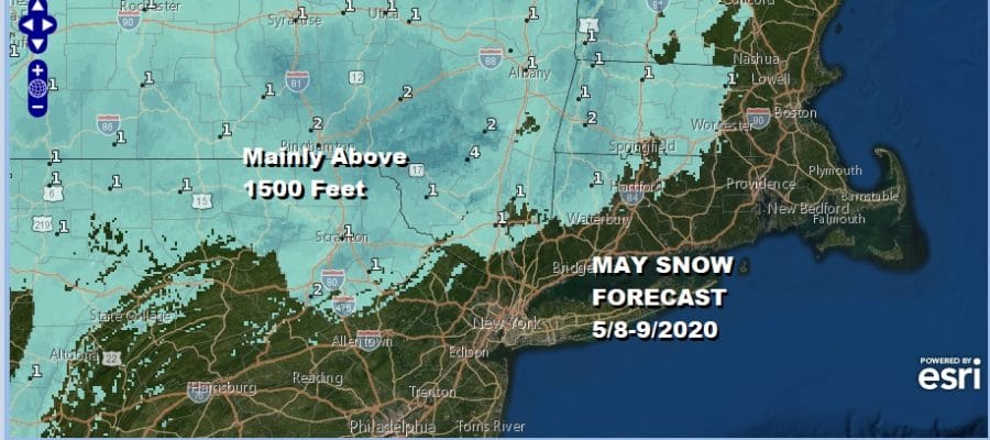
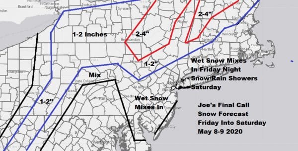
Here we area ahead of what will be a very cold May weekend across the Northeast and Mid Atlantic states. Freezes, wet snow, rain, strong winds are all on the table. Sunday is Mother’s Day which actually will turn out to be the better of the two weekend days relatively speaking. It will feature less wind, more sunshine and higher temperatures than Saturday but still well below normal. As to the wet snow issue my snow forecast map is up and I made no changes. For most it will be a matter of whether you see some wet snowflakes mix in but I suppose it is the principal of the thing that we are talking about snow in May. At least it isn’t locusts. Accumulations will be confined to elevated areas above at least 1000 feet and possibly above 1500 feet. If you are in the Poconos, Catskills, or Berkshires, you will see some accumulating snow tonight.
SATELLITE
REGIONAL RADAR
We are starting to see clouds and rain loading up on satellites and radars this afternoon with a steadier heavier rain coming out of Ohio and heading to the coast late today and tonight. Rainfall amounts will be on the order of a half to 3/4 of an inch. Temperatures today will remain in the 50s.
LOCAL RADAR NEW YORK CITY
LOCAL RADAR PHILADELPHIA

Once rain takes hold temperatures will fall into the 30s overnight. Rain or a mix of rain and wet snow ends around 1 or 2 am. Then it turns windy and cold for Saturday with self destructive sunshine and the chance for passing scattered rain or snow showers. Highs will be in the 40s at best.
Sunday morning wiil be very cold with most lows in the low to mid 30s and some areas experiencing a late spring freeze. Mothers day will feature sunshine with some arriving late day clouds. Highs will be back into the 50s and while it will still be breezy, the winds will be lower than Saturday.
Next on the weather system hit parade will be a diving system from the Great Lakes that heads for the New Jersey coast Monday with clouds and the chance for a couple of showers. It does’t look to be a big deal. Highs will be in the 50s to near 60. As we move through next week the extreme nature of the pattern should relax a bit and we will see temperatures trending back closer to average for this time of year.
BE SURE TO DOWNLOAD THE FREE METEOROLOGIST JOE CIOFFI WEATHER APP &
ANGRY BEN’S FREE WEATHER APP “THE ANGRY WEATHERMAN!
MANY THANKS TO TROPICAL TIDBITS FOR THE USE OF MAPS
Please note that with regards to any severe weather, tropical storms, or hurricanes, should a storm be threatening, please consult your local National Weather Service office or your local government officials about what action you should be taking to protect life and property.


