Rain Into Friday Afternoon, Warm Weekend Atmosphere Preps for Isaias Moving Up East Coast
While we are under a marginal risk for severe weather this evening showers and thunderstorms have been few and far between so far. A frontal boundary lies overhead with lots of clouds. This helped to keep temperatures down in some areas but where there was ample sunshine we did see highs reach 90 or better again. Clouds extend back westward into the Ohio Valley where we have a rather large area of rain at the moment moving eastward. None of that gets here until later tonight.
SATELLITE

REGIONAL RADAR

Regional radar is picking up on the heavy rains in Southwest Pennylvania south into Virginia and West Virginia sliding to the east while the local radars are showing some widely scattered showers and thunderstorms. The vast majority of you will miss out on the activity this evening but you should get into some of that rain to the west beginning early Friday morning.
LOCAL RADAR NEW YORK CITY

LOCAL RADAR PHILADELPHIA


We will have a cold front stalling out on top of us tonight and a wave of low pressure that will move along it overnight into Friday morning. It is rather likely that some of you may be woken by cracks of thunder Friday morning if the HRRR model has anything to say about it.
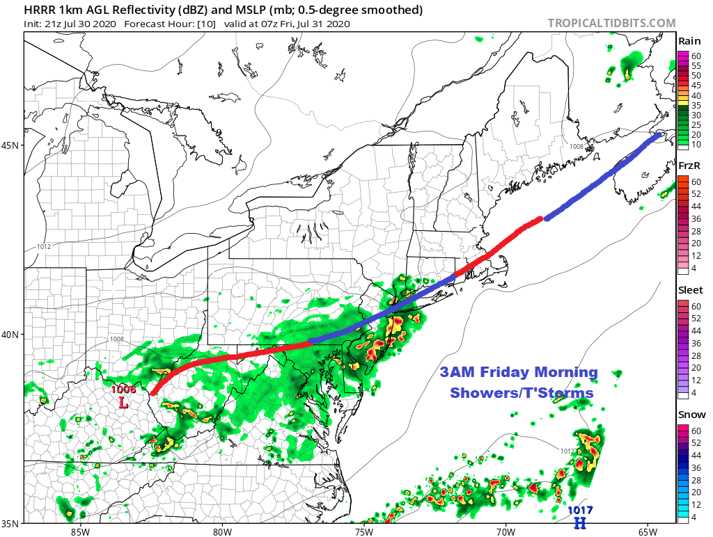
We probably won’t see the rain move out until late morning or early afternoon and then sky conditions should try to improve. While the rain is around temperatures will be in the 70s but if the sun breaks out then some areas will likely see temperatures rise into the 80s.
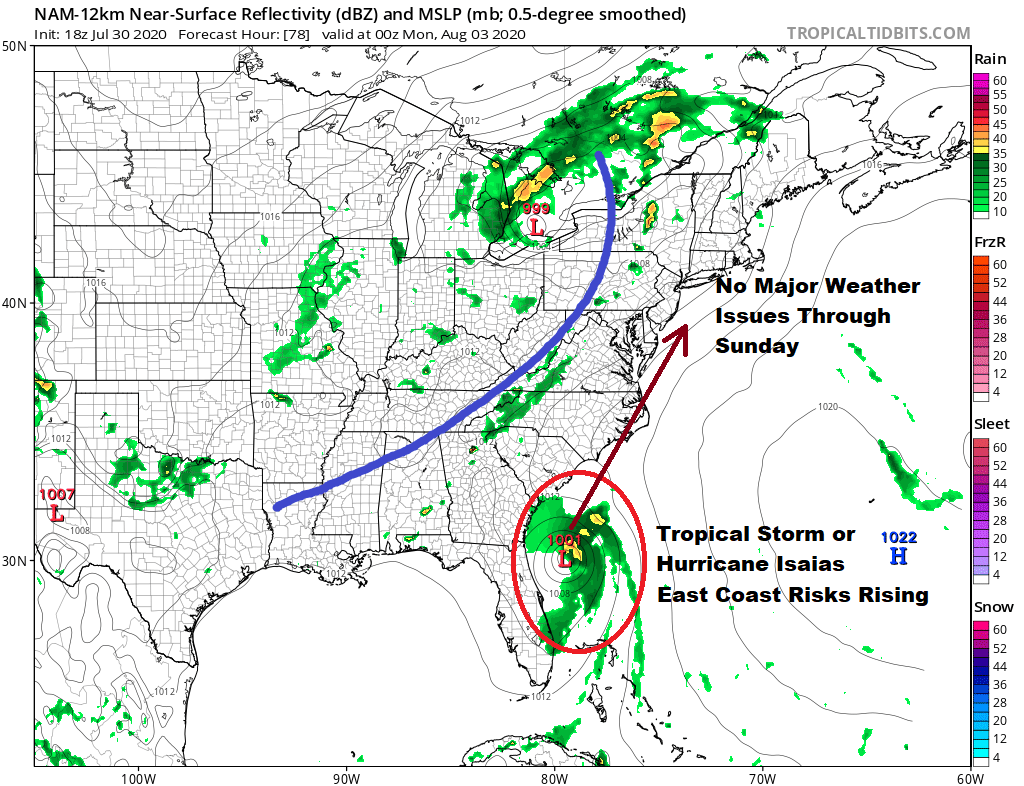
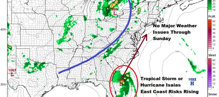
As far as the weekend is concerned there are no major weather issues other than the chance for a scattered shower or thunderstorm Saturday and Sunday. The weekend will be warm and somewhat humid but bearable Saturday but humidity levels will be rising Sunday as the atmosphere turns tropical up and down the East Coast, basically setting the table up for Isaias which will be either a strong tropical storm or possibly a hurricane as it turns northward. The alley way is set with the cold front to the west and a southerly flow along the east coast aloft. We have a deep trough in the Great Lakes that extends south to the Central Gulf Coast setting the pathway.
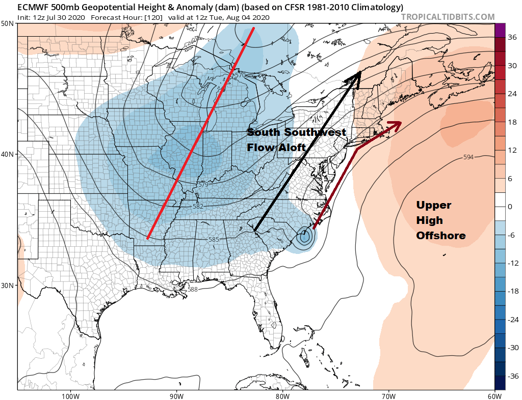
Today’s weather models illustrate the set up well as they all basically agree on the idea but it is the fine details between the strength of the ridge to the east and the deep trough to the west. That will determine whether we have a storm that passes north northeast with the center remaining offshore, but not by much, or we have a coast hugger that shoots straight northward with a landfall somewhere.

The National Hurricane Center’s hurricane tracking models are very tightly clustered and lend a high degree of confidence on the turn up the coast. We have the next several days which includes the weekend to fine tune the forecast. There certainly could be a chance that this slides out further east minimizing impact to the coastal waters. For now we watch.
TROPICAL STORM ISAIAS 8PM ADVISORY
LOCATION…19.9N 71.2W
ABOUT 45 MI…70 KM WNW OF PUERTO PLATA DOMINICAN REPUBLIC
ABOUT 155 MI…245 KM ESE OF GREAT INAGUA ISLAND
MAXIMUM SUSTAINED WINDS…60 MPH…95 KM/H
PRESENT MOVEMENT…NW OR 310 DEGREES AT 20 MPH…31 KM/H
MINIMUM CENTRAL PRESSURE…999 MB…29.50 INCHES

Satellite pictures and loops tonight show Isaias is become better organized as the center seems to be reforming under a mid level center north of the Dominican Republic. There has a been convection bursting and increasing all evening long. Isaias is moving northwestward at a slower 18 mph and is now headed for the Bahamas where Tropical Storm Warnings are posted. We also have a Tropical Storm Watch posted for the east coast of Florida from Ocean Reef at the start of the Keys northward to Sebastian Inlet.

The National Hurricane Center forecast shows a track just east of Florida to just east of New Jersey by Tuesday afternoon. Also the hurricane center is forecasting this to strengthen to a hurricane as it nears the Florida coast.
BE SURE TO DOWNLOAD THE FREE METEOROLOGIST JOE CIOFFI WEATHER APP &
ANGRY BEN’S FREE WEATHER APP “THE ANGRY WEATHERMAN!
MANY THANKS TO TROPICAL TIDBITS FOR THE USE OF MAPS
Please note that with regards to any severe weather, tropical storms, or hurricanes, should a storm be threatening, please consult your local National Weather Service office or your local government officials about what action you should be taking to protect life and property.


