Radars Loading Up As Showers Move Slowly Northward
Radars Loading Up As Showers Move Slowly Northward
The satellite loop this afternoon show that the northern extent of the cloud cover has pushed northward though it continues to struggle against dry air to the northeast. To the south from Southern New Jersey to South Central Pennsylvania, Maryland and Northeast Virginia the radar is showing some rain and a few heavier downpours in the mix. They will continue for the remainder of the afternoon and continue to inch northward. All of this is thanks to a warm front to the south and low pressure that is moving only very slowly northeastward from the Ohio Valley. It will reach the lower Great Lakes later Saturday which means that the warm front struggles northward. On and off showers will continue Saturday.
EASTERN SATELLITE

REGIONAL RADAR

LOCAL RADAR NEW YORK CITY

LOCAL RADAR PHILADELPHIA


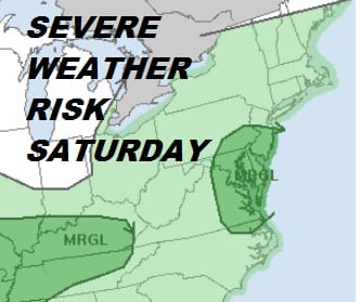
Saturday will also see the possibility of some isolated severe thunderstorms from Central & Southern New Jersey, Southeastern Pennsylvania back into parts of South Central Pennsylvania but that will depend on the progress of the warm front. If it makes it far enough north it does open up the possibility of some stronger thunderstorms developing late in the afternoon and evening.

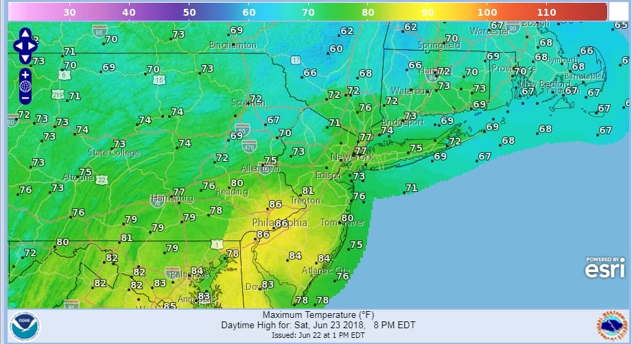
The temperatures on Saturday are a tough call too. Areas that get into the warm air will see highs reach into the 80s with low to mid 70s elsewhere. Sunday everyone should be in the warm humid air and highs will be in the 80s. Thunderstorms are likely to develop late in the day and Sunday evening as a cold front approaches.
SATURDAY FORECAST HIGH TEMPERATURES
SUNDAY FORECAST HIGH TEMPERATURES

Lower humidity and increasing amounts of sunshine will return for the first part of next week as high pressure builds down from Canada. Highs will be in the 80s Monday and in the upper 70s and lower 80s Tuesday and Wednesday. We will be making a transition to hot humid weather for Thursday and Friday of next week with a warm front coming Wednesday night with a few downpours or a thunderstorms. Then it will be hot and humid for Thursday and Friday with highs reaching the upper 80s and lower 90s in many areas.
JOESTRADAMUS HAS MORE ON THE LONG RANGE OUTLOOK.
 GET JOE A CIGAR IF YOU LIKE

LATEST JOESTRADAMUS ON THE LONG RANGE


