QUIET WEATHER CONDITIONS ALL WORK WEEK WITH NO RAIN
NEXT COLD SHOT ARRIVES WEDNESDAY
NOREASTER THREAT CONTINUES FOR THE WEEKEND
We started out rather cold this morning as temperatures bottomed in the upper 20s to middle 30s and we are seeing some sunshine starting off the day but the satellite loop does show clouds coming through from the northwest. This is likely to cut of some of the heating today but no rain is forecast. Nor is there any rain forecast for this entire work week. Temperatures today should make it back into the 50s and we have much less in the way of wind today. Nothing is showing up on the regional and local radars today and those radars get a nice long break from activity.
EASTERN SATELLITE
REGIONAL RADAR
Tonight won’t be as chilly as the next front approaches so 30s and 40s will do it for overnight lows and then Tuesday we should see at least some sunshine with highs reaching into the 60s in some areas though areas north and west of NYC might not get much out of the 50s. Tuesday is the one relatively mild day but again this warm up is totally sub par as the next cold front moves through.
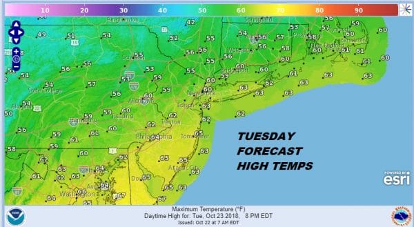
Tuesday we will see sunshine with a few clouds and no showers are forecast with the cold front coming through. This sets us up for a very chilly stretch from Wednesday though Friday with some sunshine each day. However a northerly wind screaming down the Hudson Valley will be bringing in some rather cold temperatures with highs Wednesday through Friday not out of the 40s in many places and Thursday morning will be quite cold with the potential for the first freezes for the big cities and the immediate coast.
NOREASTER THREAT CONTINUES FOR THE WEEKEND
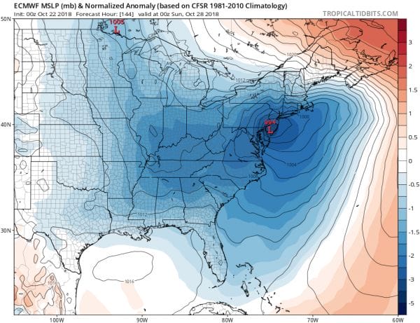
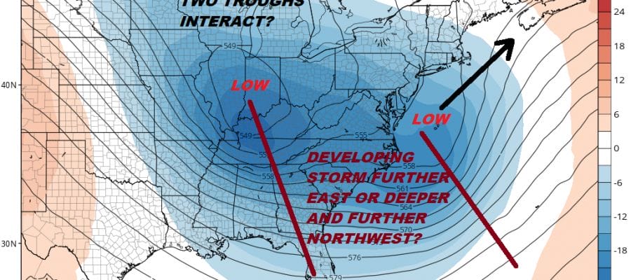
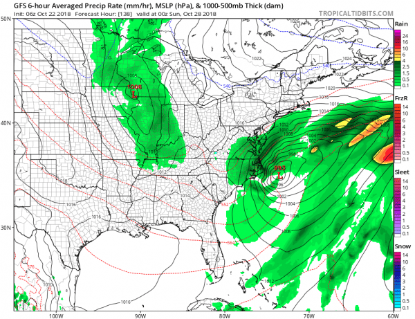
Overnight weather models haven’t swayed to much regarding the noreaster threat for the Middle Atlantic & Northeast for later Saturday and Sunday. I don’t think we are much closer to resolving all this. What is interesting is that the upper air and surface pattern a month from now would likely lead to a snowy outcome for a lot of areas. Indeed the GFS with its now offshore solution makes it a possibilty for New England and Upstate NY. The European also shows this possibility.
The GFS has the least problematic solution with rains only for the coast late Saturday and Saturday night and then a cold wet rain/snow for New England next Sunday particularly for elevated areas. We aren’t quite there yet forecast wise and would like to see more.
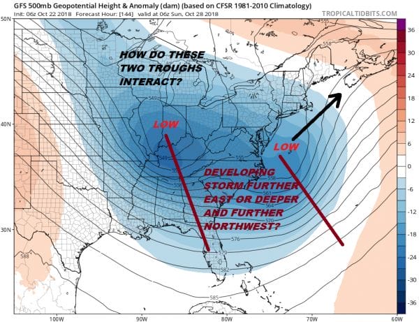
The upper air shows the battle here between the 2 troughs. The GFS has been trending toward the idea of the trough along the East Coast to be kicked away to the northeast rather than being lifted up to the north. A kick to the northeast makes for a flatter potentially colder solution. The upper low to the west is going the be key here. If it lifts it northward it makes for a stronger storm with wind and rain. We still aren’t there yet regarding the weekend but we are getting closer.
LOOK FOR A LIVE STREAM THIS MORNING AT 9:30 FOR PATREON MEMBERS
SUBSCRIBE TO PATREON FOR A WEATHER EXPERIENCE FREE OF ADS, EXCLUSIVE VIDEOS FOR MEMBERS ONLY AND MUCH MORE…STARTS AT $2 A MONTH..MESSAGE ME AT ANY TIME
MANY THANKS TO TROPICAL TIDBITS FOR THE USE OF MAPS
Please note that with regards to any tropical storms or hurricanes, should a storm be threatening, please consult your local National Weather Service office or your local government officials about what action you should be taking to protect life and property.
LATEST JOESTRADAMUS ON THE LONG RANGE

