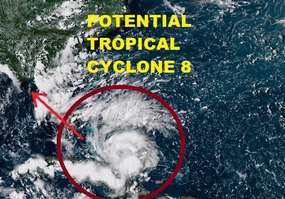
Tropical Wave Becomes Better Organized Over Bahamas
Tropical Depreesion or Tropical Storm Forecast to Form In Gulf of Mexico
Threat to the Central Gulf Coast Midweek
Latest satellite loops and radars show that the tropical wave moving through the Bahamas east of the Florida east coast is becoming better organized as it heads westward. Upper air conditions have become more favorable for development particularly Monday and Tuesday when the system enters the Gulf of Mexico. The National Hurricane Center has initiated Potential Tropical Cyclone advisories this evening.

Potential Tropical Cyclone Seven Advisory Number 1
NWS National Hurricane Center Miami FL AL072018
500 PM EDT Sun Sep 02 2018
…TROPICAL STORM CONDITIONS AND HEAVY RAINFALL POSSIBLE OVER
PORTIONS OF THE CENTRAL GULF COAST TUESDAY NIGHT AND WEDNESDAY…
SUMMARY OF 500 PM EDT…2100 UTC…INFORMATION
———————————————-
LOCATION…22.7N 77.3W
ABOUT 100 MI…155 KM NNE OF CAMAGUEY CUBA
ABOUT 275 MI…445 KM ESE OF MARATHON FLORIDA
MAXIMUM SUSTAINED WINDS…30 MPH…45 KM/H
PRESENT MOVEMENT…WNW OR 300 DEGREES AT 15 MPH…24 KM/H
MINIMUM CENTRAL PRESSURE…1012 MB…29.89 INCHES
WATCHES AND WARNINGS
——————–
CHANGES WITH THIS ADVISORY:
A Tropical Storm Watch has been issued for portions of the central
Gulf Coast from the Alabama-Florida border westward to east of
Morgan City, Louisiana, including Lake Pontchartrain and Lake
Maurepas.
SUMMARY OF WATCHES AND WARNINGS IN EFFECT:
A Tropical Storm Watch is in effect for…
* Alabama-Florida border westward to east of Morgan City, Louisiana,
including Lake Pontchartrain and Lake Maurepas
Interests in the Florida Keys and the southern Florida peninsula
should monitor the progress of this system.
For storm information specific to your area, including possible
inland watches and warnings, please monitor products issued by your
local National Weather Service forecast office.
DISCUSSION AND OUTLOOK
———————-
At 500 PM EDT (2100 UTC), the disturbance was centered near latitude
22.7 North, longitude 77.3 West. The system is moving toward the
west-northwest near 15 mph (24 km/h), and this general motion is
expected to continue through Wednesday. On the forecast track, the
disturbance will pass over the Florida Keys Monday afternoon, emerge
over the southeastern Gulf of Mexico by Monday evening, and reach
the central Gulf Coast by Tuesday night or Wednesday morning.
Maximum sustained winds are near 30 mph (45 km/h) with higher gusts.
Gradual strengthening is forecast during the next 48 hours, and the
disturbance is expected to become a tropical depression Monday
morning and a tropical storm by Monday evening.
Conditions appear to be conducive for development, and this system
is expected to become a tropical depression by Monday morning.
* Formation chance through 48 hours…high…80 percent
* Formation chance through 5 days…high…90 percent
The estimated minimum central pressure is 1012 mb (29.89 inches).
HAZARDS AFFECTING LAND
———————-
WIND: Tropical storm conditions are possible within the watch
area by Tuesday night and Wednesday. Tropical-storm-force wind gusts
will be possible Monday afternoon and evening across portions of
South Florida and the Florida Keys.
RAINFALL: The disturbance is expected to produce total rain
accumulations of 2 to 4 inches over the central and northwestern
Bahamas, the Florida Keys, and South Florida through early Tuesday.
Isolated maximum amounts of 8 inches are possible over the southern
Florida peninsula. This rainfall may cause flash flooding. The
disturbance is expected to produce heavy rainfall along the central
Gulf Coast of the United States by the middle of the week.
This is the National Hurricane Center’s forecast which brings this system ashore as a tropical storm along the Central Gulf Coast Tuesday night or Wednesday. This system is forecast to strengthen somewhat. Time probably limits the strengthening here so at this point it seems unlikley that this reaches hurricane strength though it is going to be passing over 30 degree C water which is very warm. Upper air wind conditions will be favorable all along the track so this system could strengthen right up until the point of landfall.
RADAR MIAMI
LOCAL RADAR KEY WEST

In the meantime heavy rains are likely over South Florida and the keys until the wave clears Florida and moves into the open waters of the Gulf of Mexico later Monday. Up to 5 inches of rain is possible in some places in South Florida. At the moment radars across South Florida are rather quiet but activity will begin to increase tonight and Monday as the wave moves through and strengthens.


