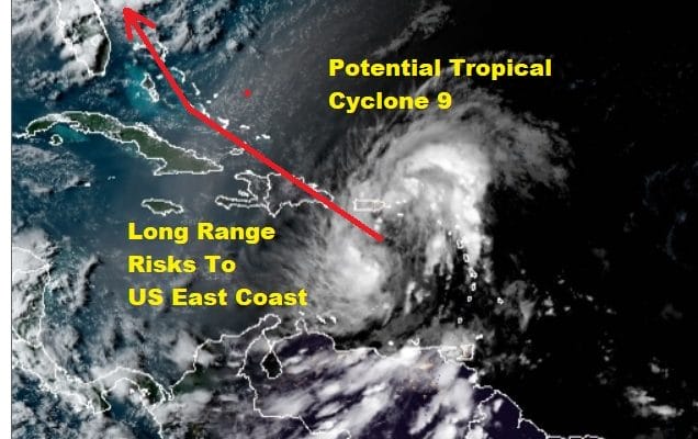
Potential Tropical Cyclone 9 Close to Tropical Storm Strength
We seem to be getting a little closer to getting a closed circulation in this broad area of low pressure a.k.a. Potential Tropical Cyclone 9. We will have to wait for the next recon that will go in tonight to see if that has been achieved. For now we are seeing bands of rain on the radar over Puerto Rico as well as areas to the northeast and north of the island as well as over the Virgin Islands. So far winds have been busy from the northeast and east with some gusts in to the mid and high 20s. Nothing outstanding there for the moment.
TROPICAL SYSTEM

5PM LOCATION…16.4N 65.6W
ABOUT 105 MI…170 KM SSW OF ST. CROIX
ABOUT 320 MI…510 KM ESE OF SANTO DOMINGO DOMINICAN REPUBLIC
MAXIMUM SUSTAINED WINDS…45 MPH…75 KM/H
PRESENT MOVEMENT…WNW OR 290 DEGREES AT 23 MPH…37 KM/H
MINIMUM CENTRAL PRESSURE…1004 MB…29.65 INCHES
A Tropical Storm Warning is in effect for Puerto Rico, Vieques, Culebra, U.S. Virgin Islands, British Virgin Islands, Anguilla, St. Martin and St. Barthelemy, Saba and St. Eustatius, St. Maarten, Dominican Republic entire southern and northern coastlines, North coast of Haiti from Le Mole St Nicholas eastward to the
northern border with the Dominican Republic, Turks and Caicos Islands, Southeastern Bahamas including the Acklins, Crooked Island, Long Cay, the Inaguas, Mayaguana, and the Ragged Islands
A Tropical Storm Watch is in effect for Central Bahamas, including Cat Island, the Exumas, Long Island,
Rum Cay, and San Salvador.
This afternoon’s run of Hurricane model guidance shifted to the east from prior runs though the models are split with some taking a more western route into the Gulf of Mexico while the others keep it along or just offshore the Florida east coast. Then there is the run through the Carolinas and northward though some start to turn it more to the northeast over time. Obviously the variability widens as we go out longer in time.
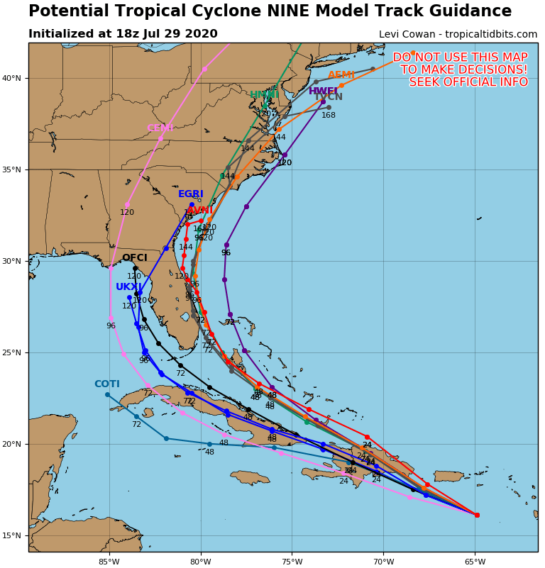
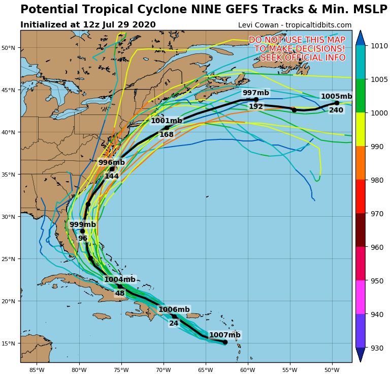
The ensemble GFS looks much like yesterday’s did with the mean track of all the members in black and then the individual tracks laid out by each model variation. It really doesn’t help us very much because we still need to resolve the issue of strength.
The fact that a low level center has not formed yet makes the forecast difficult since a weaker system will tend to track more on the southern end of the model tracks. This brings the system over the Dominican Republic and Haiti and the Cuba. The mountainous terrain of these islands will disrupt the system even more and likely weaken it. However if the center does clear the islands to the north there is a better chance for strengthening in the longer term.

The late afternoon GFS continues the trend further east and it also shows a more robust cyclone heading up the East Coast. The key to this will be the upper air trough to the west as it develops a south southwest flow along the East Coast bringing the system northward. Of course first and foremost is that Potential Tropical Cyclone 9 needs to actually become a tropical cyclone!
BE SURE TO DOWNLOAD THE FREE METEOROLOGIST JOE CIOFFI WEATHER APP &
ANGRY BEN’S FREE WEATHER APP “THE ANGRY WEATHERMAN!
MANY THANKS TO TROPICAL TIDBITS FOR THE USE OF MAPS
Please note that with regards to any severe weather, tropical storms, or hurricanes, should a storm be threatening, please consult your local National Weather Service office or your local government officials about what action you should be taking to protect life and property.