Tropical Storm Isaias 60 MPH Heading Toward Dominican Republic Bahamas
Risks To US East Coast This Weekend
Overnight we saw increased organization and a concentration of tropical storm force winds so it was time for an upgrade and we now have Isaias which is the seasons 9th named storm and two records were broken as it is the earliest 9th storm on record. and the 5th storm for the month of July which ties a record. Both of these records go back to 2005.
8AM LOCATION…17.6N 68.5W
ABOUT 125 MI…205 KM W OF PONCE PUERTO RICO
ABOUT 105 MI…175 KM ESE OF SANTO DOMINGO DOMINICAN REPUBLIC
MAXIMUM SUSTAINED WINDS…60 MPH…95 KM/H
PRESENT MOVEMENT…NW OR 305 DEGREES AT 20 MPH…31 KM/H
MINIMUM CENTRAL PRESSURE…1003 MB…29.62 INCHES
TROPICAL SYSTEM

The satellite presentation has improved however there still is a bit of a disjointed look to this tropical storm. Nonetheless, heavy rains are continuing over Puerto Rico this morning and those rains will be spreading over the Dominican Republic and points northwestward. A Tropical Storm Warning is in effect for Puerto Rico, Vieques, Culebra, U.S. Virgin Islands, British Virgin Islands, Dominican Republic entire southern and northern coastlines, North coast of Haiti from Le Mole St Nicholas eastward to the
northern border with the Dominican Republic, Turks and Caicos Islands, Southeastern Bahamas including the Acklins, Crooked Island, Long, Cay, the Inaguas, Mayaguana, and the Ragged Islands, Central Bahamas, including Cat Island, the Exumas, Long Island, Rum Cay, and San Salvador
A Tropical Storm Watch is in effect for Northwestern Bahamas including Andros Island, New Providence,
Eleuthera, Abacos Islands, Berry Islands, Grand Bahamas Island, and Bimini.

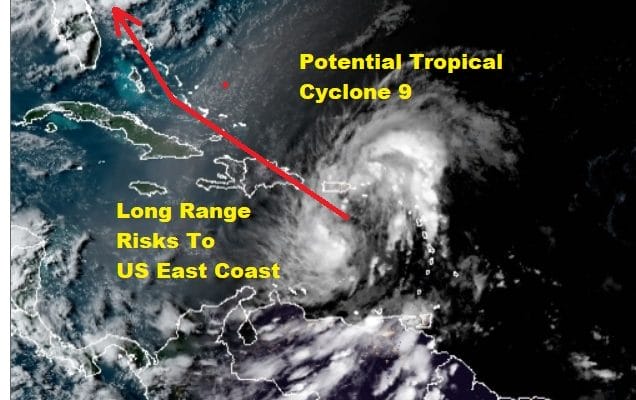
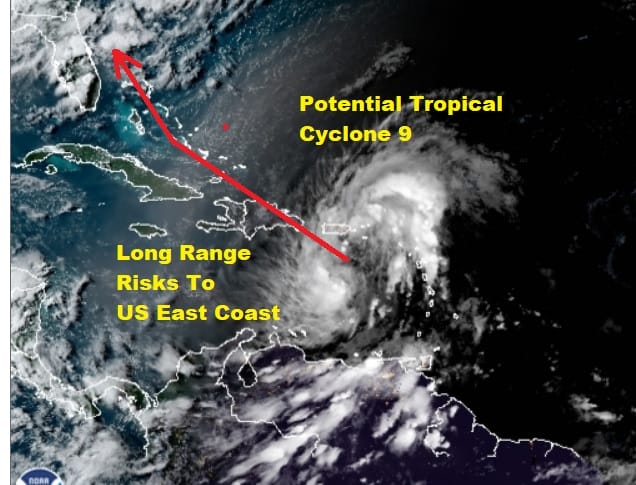
The set up in the upper air opens the risks up for the East Coast. To the southeast we have the subtropical Atlantic upper ridge. To the northwest we have a strong upper trough dropping into the Ohio Valley. In between is the weakness between the two and Isaias will likely head into that weakness and gradually turn northward. The orientation of the trough and the strength of the ridge are the keys here regarding the threat to Florida, the Carolinas, and perhaps the Northern Mid Atlantic to Southern New England.

The National Hurricane Center has shifted its forecast track to the east which matches up fairly well with the Hurricane tracking models which also have shifted the track to the east of Florida. One important factor in figuring out the long range is what is going on now. The center is going to pass over the Dominican Republic which will impact strength however we could see the center reform north of the Dominican Republic and that will impact the future outcome.
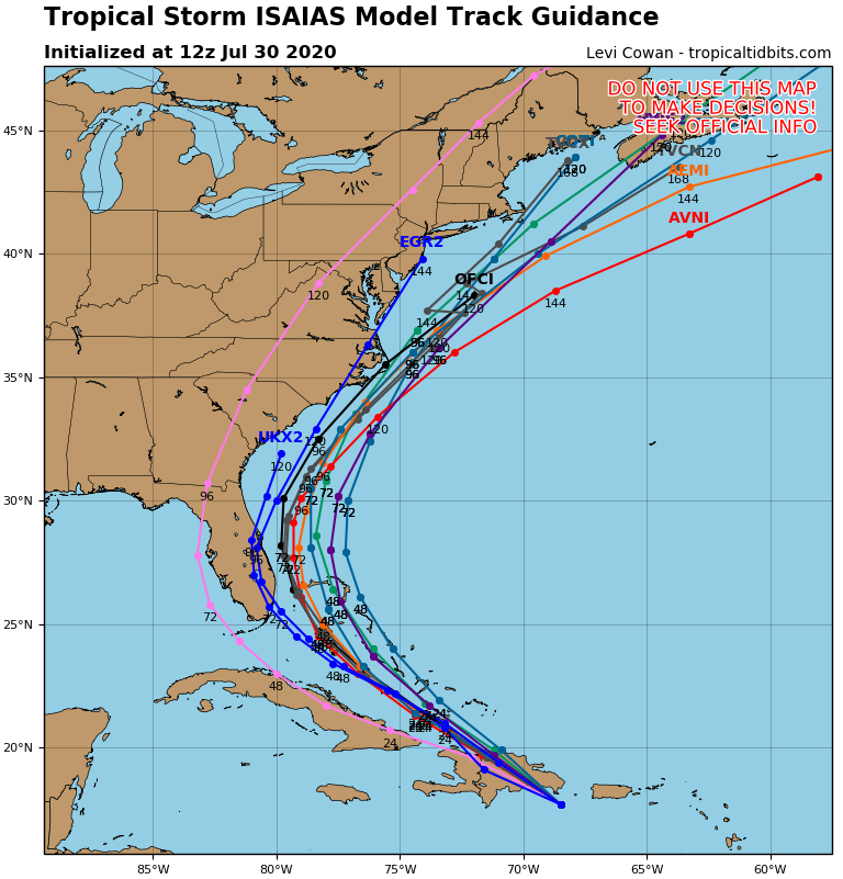
As far as strengthening is concerned we should see Isaias strengthen once it moves away from the Dominican Republic. Upper air winds show some moderate wind shear which should the strengthening back to some extent. We have seen instances where tropical systems have defied what appeared to be a hostile upper air and develop and we have also seen tropical systems not respond to ideal strengthening conditions. It is a bit of a mystery then as to what we will be dealing with here. Right now the forecast is for Isaias to remain a tropical storm through its life cycle but how it behaves after its interaction with the Dominican Republic will be key.
BE SURE TO DOWNLOAD THE FREE METEOROLOGIST JOE CIOFFI WEATHER APP &
ANGRY BEN’S FREE WEATHER APP “THE ANGRY WEATHERMAN!
MANY THANKS TO TROPICAL TIDBITS FOR THE USE OF MAPS
Please note that with regards to any severe weather, tropical storms, or hurricanes, should a storm be threatening, please consult your local National Weather Service office or your local government officials about what action you should be taking to protect life and property.