Patchy Light Rain Overnight Gloom And Doom Clouds All Week Zeta Rains Late Week

Weather in 5/Joe & Joe Weather Show Latest Podcast
Patchy Light Rain Overnight Gloom And Doom Clouds All Week Zeta Rains Late Week
Weak low pressure off the Carolinas on yesterday’s front (now stalled out to our south) has pushed up clouds and some patchy areas of rain. It seems that the heaviest rain is to the south and east and should likely stay mostly south and east. That leaves us with patches of rain or showers that will move through overnight. It won’t amount to much, probably a tenth of an inch or less in most places. Otherwise it is raw out there thanks to the big high and a northeast wind so temperatures will likely hold mostly in the 40s.
SATELLITE

REGIONAL RADAR

We see the disjointed nature of the regional and local radars with that heavier rain to the southeast and the patches of rain everywhere else. Such is our gloom and doom weather which comes and goes. We can’t seem to either make it rain continuously nor can we manage much of any sunshine.
LOCAL RADAR NEW YORK CITY

LOCAL RADAR PHILADELPHIA


Monday and Tuesday look pretty much the same. There is no big high coming in to sweep out the moisture so look for lots of clouds both days. There might be some patchy light rain scattered around Monday and again on Tuesday but there will be dry stretches too. Highs Monday will be in the mid 50s to lower 60s and Tuesday’s highs will be mostly in the 50s.
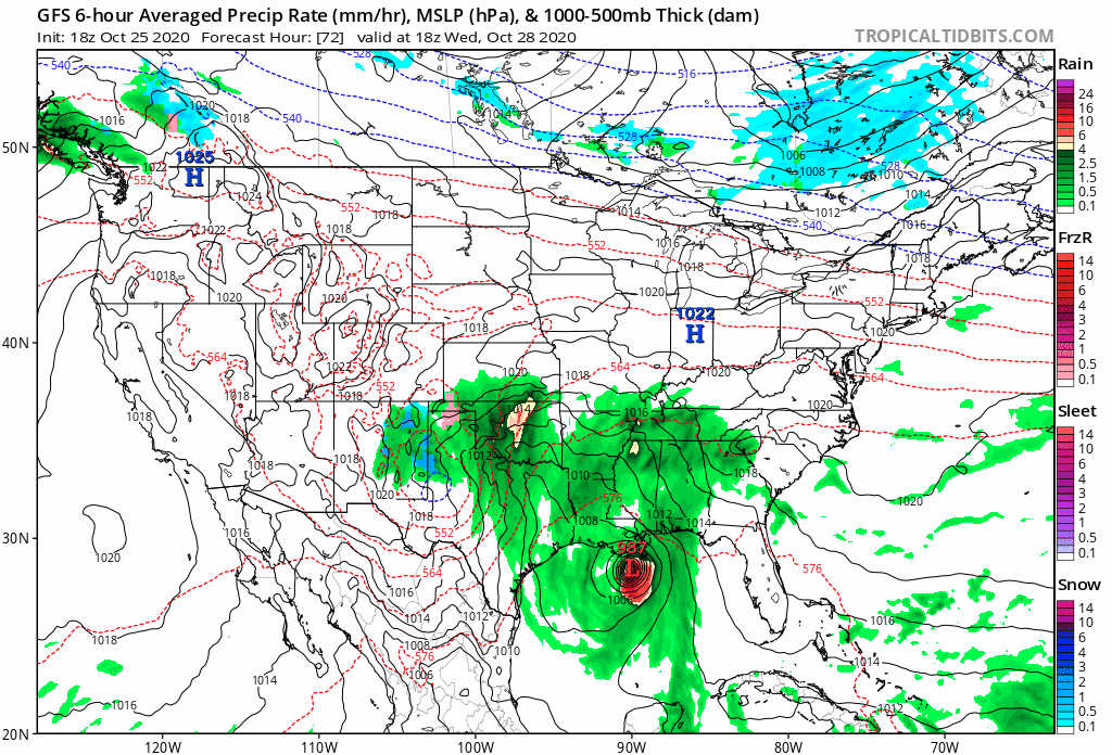
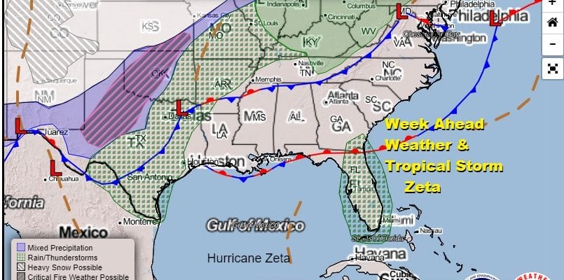
Wednesday might be the one day that we squeeze in some sunshine into the cloud cover with highs in the upper 50s and lower 60s. Then we turn our attention to low pressure coming out of the Southern Plains that picks up landfalling Tropical Storm Zeta (or Hurricane Zeta) along the Gulf Coast and carries it northeastward. This could be a potentially solid rain producer from Eastern Pennsylvania to Southern New England down to Northeast Virginia. The low will likely track to our south and that puts us into a raw ocean wind set up for Thursday and Friday. Rain conditions finish off the week. We might manage an inch or two of rain with higher amounts south, depending on the impact of tropical moisture from the remnants of Zeta. An early call on temperatures would be 50s Thursday but perhaps only upper 40s and lower 50s on Friday. If everything moves according to plan we could have a nice next weekend with both days featuring dry weather and some sunshine.
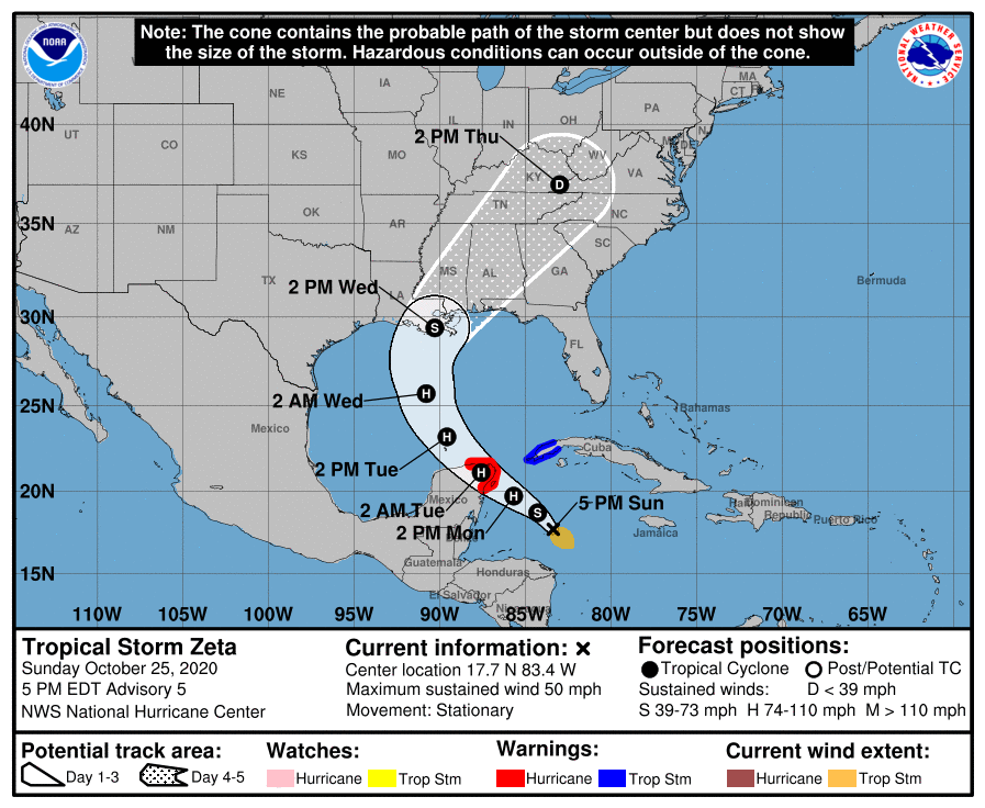
LOCATION…17.7N 83.4W
ABOUT 300 MI…480 KM SE OF COZUMEL MEXICO
MAXIMUM SUSTAINED WINDS…50 MPH…85 KM/H
PRESENT MOVEMENT…STATIONARY
MINIMUM CENTRAL PRESSURE…999 MB…29.50 INCHES
Tropical Storm Zeta spend the afternoon spinning its wheels with little movement but it has strengthened some with top winds now up to 50 mph and the central pressure has fallen under 1000 mb. The forecast logic with Zeta remains unchanged as it skims or moves over the Yucatan and then turns northward to the Central Gulf Coast for a late Wednesday landfall. There is still a wide spread on landfall but for us the main focus will be the moisture getting involved with the Southern Plains storm that brings rain here late week. Zeta could become a hurricane in the next 24 hours or so but once in the Gulf of Mexico, as it heads north it will be running into cooler water and increasing shear so it is possible that it arrives as a strong tropical storm and not a hurricane.
BE SURE TO DOWNLOAD THE FREE METEOROLOGIST JOE CIOFFI WEATHER APP &
ANGRY BEN’S FREE WEATHER APP “THE ANGRY WEATHERMAN!
MANY THANKS TO TROPICAL TIDBITS FOR THE USE OF MAPS
Please note that with regards to any severe weather, tropical storms, or hurricanes, should a storm be threatening, please consult your local National Weather Service office or your local government officials about what action you should be taking to protect life and property.


